Russian traveler, explorer, navigator, explorer of Northern and Eastern Siberia, Cossack ataman, fur trader. The first known navigator who passed through the Bering Strait, which connects the Arctic Ocean with the Pacific and separates Asia and North America, Chukotka and Alaska, and did this 80 years before Vitus Bering, in 1648.
Named after Dezhnev: a cape, an island, a bay, a peninsula, a glacier, a village, streets.
Vitus Jonassen Bering
Navigator, officer of the Russian fleet, captain-commander. Danish by origin. In 1725-1730 and 1733-1741 he led the First and Second Kamchatka expeditions. He passed through the strait between Chukotka and Alaska (later the Bering Strait), reached North America and discovered a number of islands in the Aleutian ridge.
Named after Bering: the sea, the strait, the island, the cape, the streets.
Ivan Fyodorovich Kruzenshtern
Russian navigator, admiral. Descended from Ostsee nobles. Ivan Kruzenshtern and Yuri Lisyansky on the ships "Nadezhda" and "Neva" made the first Russian round-the-world expedition.
Named after Kruzenshtern: an island, a strait, a reef.
Yuri Fyodorovich Lisyansky
Russian navigator and explorer. Captain of the first rank. Born in the family of an archpriest in the city of Nizhyn. While studying at the Naval Cadet Corps, he became friends with I.F. Kruzenshtern.
Named after Lisyansky: an island, a cape, a strait, peninsulas, a bay, a bay, a seamount, a river, a street, a public garden.
Pyotr Ivanovich Rikord
Russian admiral, traveler, scientist, diplomat, writer, shipbuilder, statesman and public figure. Rikord's notes on the voyage to the Japanese coast have been translated into English, French and other languages.
Named after Rikord: an island, a cape, a river, a strait, an underwater volcano, a mountain peak.
Faddey Faddeevich Bellingshausen
Russian navigator, admiral, discoverer of Antarctica. By origin - a Baltic German from the Baltic noble family of Bellingshausen. In 1803-1806, Bellingshausen participated in the first round-the-world voyage of Russian ships on the Nadezhda sloop under the command of Ivan Krusenstern. After the accession to the throne of Emperor Nicholas I, Bellingshausen was appointed a member of the committee for the formation of the fleet and in 1826 was promoted to the rank of Rear Admiral.
Named after Bellingshausen: sea, cape, islands, bay, glacier.
Mikhail Petrovich Lazarev
Russian naval commander and navigator, admiral, holder of the Order of St. George IV class for long service, commander of the Black Sea Fleet and discoverer of Antarctica.
The following are named after Lazarev: the sea, the atoll, capes, reef, river, bay, island, mountain range, glacier, seamount, streets, squares, bridges.
Fyodor Petrovich Wrangel
Russian military and statesman, navigator and polar explorer, admiral, head of the Naval Ministry. Proceedings: “Daytime notes on the voyage of the military transport“ Meek ”; "Sketch of the way from Sitka to St. Petersburg"; "Historical Review of Travels in the Arctic Ocean"; "Journey along the northern shores of Siberia and the Arctic Ocean, committed in 1820-1824."
The islands are named after Wrangel.
Pyotr Fyodorovich Anzhu
Admiral, member of the Council of the Minister of State Property, polar explorer. In 1825-1826, Anzhu participated in a military-scientific expedition, in the description of the northeastern coast of the Caspian and the western coast of the Aral Sea, under the command of Colonel F.F. Berg.
The northern group of islands is named after Anjou.
Pyotr Petrovich Semyonov-Tyan-Shansky
Russian geographer, botanist, statistician, economist, statesman and public figure. The postscript "Tyan-Shansky" received when he visited the Tien-Shan Mountains. Vice-Chairman of the Imperial Russian Geographical Society.
A number of geographical objects in Central and Central Asia, the Caucasus, Alaska and Svalbard and about 100 new forms of plants and animals are named after Semyonov-Tyan-Shansky.
Nikolai Mikhailovich Przhevalsky
Russian traveler and naturalist. Undertook several expeditions to Central Asia. In 1878 he was elected an honorary member of the Academy of Sciences. Major General.
Named after Przhevalsky: a ridge, a glacier, mountains, a cave, a rock mass, a city, a village, streets.
Nikolai Nikolaevich Miklukho-Maclay
Russian ethnographer, anthropologist, biologist and traveler who studied the indigenous population of Southeast Asia, Australia and Oceania, including the Papuans of the northeastern coast of New Guinea, called the Maclay Coast. Miklouho-Maclay's birthday is unofficially celebrated as a professional holiday for ethnographers.
Named after Miklukho-Maclay: the northeastern coast of New Guinea, the bay, the streets.
Pavel Yakovlevich Pyasetsky
Russian doctor, traveler, artist, writer. A well-known merit of Pyasetsky was the introduction of kefir into domestic medical practice, which until that time was almost unknown in Russia. Pavel Yakovlevich brought it back from a short trip to the North Caucasus. Pyasetsky was one of the first, along with Mechnikov, to promote the medicinal properties of kefir, thereby contributing to its distribution in the diet of Russian residents.
Alexander Ksaverievich Bulatovich
Russian scientist and religious figure. A researcher of Ethiopia, an officer, later a hieroschemamonk, in April 1896, as a courier, he made the legendary camel run from Djibouti to Harer, covering a distance of over 350 miles across the mountainous desert in 3 days and 18 hours, which is 6-18 hours faster than professional couriers. Bulatovich is the first European who crossed Kaffa (now a province of Ethiopia) from end to end. Subsequently, he compiled the first scientific description of Kaffa. He also became the second European to discover the mouth of the Omo River.
Nicholas Roerich
Russian artist, stage designer, mystic philosopher, writer, traveler, archaeologist, public figure. Academician of the Imperial (Russian) Academy of Arts. He was engaged in archeology, collecting, as an artist he successfully exhibited, participated in the design and painting of churches, headed the art association "World of Art", successfully worked as a stage designer.
Named after Roerich: peak, passes, glacier.
Robert Peary
American Arctic explorer, traveler. He devoted 23 years of his life to the task of reaching the North Pole, carried out several expeditions to Greenland and the Central Arctic. Officially considered the first person to reach the North Pole. According to him, this happened on April 6, 1909.
Named after Piri: a peninsula, an island, a mountain.
Fridtjof Nansen
Norwegian polar explorer, scientist - doctor of zoology, founder of a new science - physical oceanography, political and public figure, humanist, philanthropist, Nobel Peace Prize winner in 1922, awarded by many countries, including Russia. At the age of 27, for the first time in history, he crossed the ice sheet of Greenland on skis.
Named Nansen: hollow, ridge, mountains, islands.
Robert Scott
Captain of the Royal Navy of Great Britain, polar explorer, one of the discoverers of the South Pole, who led two expeditions to Antarctica: "Discovery" and "Terra Nova". During the second expedition, Scott, along with four other members of the campaign, reached the South Pole on January 17, 1912, but found that they were several weeks ahead of the Norwegian expedition of Roald Amundsen.
Vladimir Alexandrovich Rusanov
Russian Arctic explorer, geologist, traveler. He made the first land voyage in history on Novaya Zemlya, he crossed it from Neznaniy Bay to Krestovaya Bay on the western side of the island. It should be noted that only one Rusanov reached the Barents Sea, the rest of the travelers, unable to withstand the difficulties of the journey, fell behind.
Rusanov's name is given to: a bay, a peninsula, a glacier, a mountain, streets.
Georgy Yakovlevich Sedov
Russian hydrographer, polar explorer, naval officer (senior lieutenant), full member of the Russian Geographical Society, honorary member of the Russian Astronomical Society. Participated in expeditions to study the island of Vaigach, the mouth of the Kara River, Novaya Zemlya, the Kara Sea, the Caspian Sea, the mouth of the Kolyma River and sea approaches to it, Krestovaya Bay.
Named after Sedov: archipelago, islands, glacier, cape, village, streets.
Konstantin Eduardovich Tsiolkovsky
Russian and Soviet self-taught scientist and inventor, school teacher. Founder of theoretical astronautics. He substantiated the use of rockets for flights into space, came to the conclusion that it was necessary to use "rocket trains" - prototypes of multi-stage rockets. His main scientific works relate to aeronautics, rocket dynamics and astronautics.
Named after Tsiolkovsky: the city, the streets.
Otto Yulievich Schmidt
Soviet mathematician, geographer, geophysicist, astronomer. Explorer of the Pamirs, explorer of the North, professor, academician of the Academy of Sciences of the USSR, Academy of Sciences of the Ukrainian SSR, Hero of the Soviet Union. Contributed to the study of the northern polar territories.
Named after Schmidt: cape, plain, streets.
Alexey Nikolaevich Zhokhov
Russian polar explorer, researcher-hydrographer, lieutenant of the Russian fleet. Member of the Hydrographic Expedition of the Arctic Ocean, in which he made a through passage along the entire Arctic coast from east to west.
Named after Zhokhov: an island, a lake.
Pyotr Petrovich Shirshov
Soviet statesman, hydrobiologist and polar explorer, professor, doctor of geographical sciences, academician of the USSR Academy of Sciences. He compiled a detailed biological map of the littoral and sublittoral vegetation of Novaya Zemlya.
Named after Shirshov: a bay, a lake, an underwater ridge, streets.
Mikhail Vasilievich Vodopyanov
Soviet pilot, participant in the rescue of the crew of the Chelyuskin steamer, participant in Arctic and high-latitude expeditions, Major General of Aviation, flew to the Arctic. He landed on ice for the first time using a brake parachute.
Named after Vodopyanov: the village, the streets.
Valery Pavlovich Chkalov
Soviet test pilot, brigade commander, Hero of the Soviet Union. He flew from Moscow to the Far East. The crew commander of the aircraft that made the first non-stop flight over the North Pole from Moscow to Vancouver.
Named after Chkalov: peak, island, villages, settlements, square, avenue, streets.
Georgy Filippovich Baidukov
Soviet test pilot; military leader, one of the leaders in the creation of the USSR air defense system. Colonel-General of Aviation, Hero of the Soviet Union, holder of the largest number of orders of the USSR (22 orders of the USSR).
Name Krenkel named: island, peak, village, streets.
Ernst Teodorovich Krenkel
Soviet polar explorer, professional radio operator, member of the first Soviet drifting station "North Pole-1" and other Arctic expeditions. The hero of the USSR.
Name Krenkel named: the bay, the streets.
Evgeny Konstantinovich Fedorov
Soviet geophysicist, head of the USSR Hydrometeorological Service, statesman and public figure, academician of the USSR Academy of Sciences, lieutenant general of the engineering service, head of the delegation at the first World Climate Conference.
Named after Fedorov: a group of islands, streets.
Georgy Alekseevich Ushakov
Soviet explorer of the Arctic, Doctor of Geography, author of 50 scientific discoveries. Together with Urvantsev, Khodov and Zhuravlev, they compiled the first map of the Severnaya Zemlya archipelago.
Ushakov's name is given to: a cape, a river, an island, mountains, a village.
Nikolay Vasilievich Morozov
Russian military hydrographer and polar explorer. He participated in several major polar expeditions, and from 1899 to 1905 served as assistant chief of the Hydrographic Expedition of the Arctic Ocean. He became the first boatmaster of the Kara Sea: he sailed 22 cargo ships at the mouth of the Yenisei, which transported the necessary materials for the construction of the Great Siberian Railway.
Vladimir Klavdievich Arseniev
Russian and Soviet traveler, geographer, ethnographer, writer, explorer of the Far East, military orientalist. He was engaged in cartography, statistics, archeology, geology, hydrology and meteorology, museum business.
Named after Arseniev: a glacier, a mountain, a city, a bay, streets.
Roald Amundsen
Norwegian polar traveler and record holder, "Napoleon of the polar countries" in the words of R. Huntford. First person to reach the South Pole. The first person (together with Oscar Wisting) to visit both geographic poles of the planet. The first traveler who made a sea passage through the Northwest Passage (through the straits of the Canadian Archipelago).
Named after Amundsen: sea, mountain, glacier, bay, basin.
Jacques-Yves Cousteau
French explorer of the oceans, photographer, director, inventor, author of many books and films. He was a member of the French Academy. Commander of the Order of the Legion of Honor. Known as Captain Cousteau. Together with Emil Gagnan in 1943, he developed and tested a scuba gear. Since the early 1950s, Cousteau has been conducting oceanographic research with the help of the Calypso vessel. Recognition came to Cousteau with the release of the book "In the world of silence." The film, based on the book, won the Oscar and the Palme d'Or in 1956.
Thor Heyerdahl
Norwegian archaeologist, traveler and writer, author of many books. Heyerdahl and five other travelers in Peru built a pae-pae raft, which they called the Kon-Tiki, which covered 4,300 nautical miles (8,000 km) in the Pacific Ocean. Organized the Norwegian Archaeological Expedition to Easter Island to explore a number of important archaeological sites. Examined mounds found in the Maldives in the Indian Ocean. Explored the pyramids of Guimar on the island of Tenerife. In 2000, Heyerdahl began excavations in Azov, Rostov Region.
Vitaly Georgievich Volovich
Member of the Great Patriotic War, retired colonel of the medical service, doctor of medical sciences, professor, honorary polar explorer, parachute instructor. The first person in the world to make, together with Medvedev, a parachute jump to the North Pole. Active member of the Russian Academy of Cosmonautics. K. E. Tsiolkovsky.
Viktor Ivanovich Sarianidi
Russian archaeologist, doctor of historical sciences, member of the Anthropological Society of Greece, honorary academician of the Academy of Turkmenistan. Author of over 30 books and over 300 publications. Thanks to the work of Sarianidi in Bactria and Margiana, traces of the country of Margush, known only from the inscription on the Behistun rock, were found.
Yuri Alekseyevich Gagarin
Soviet pilot-cosmonaut, Hero of the Soviet Union, holder of the highest distinctions of a number of states, honorary citizen of many Russian and foreign cities. The first person to fly into outer space.
Named after Gagarin: the city, boulevards, streets, avenues, squares.
Yuri Alexandrovich Senkevich
Soviet and Russian physician and TV journalist, traveler, TV producer, candidate of medical sciences, colonel of the medical service, laureate of the USSR State Prize, academician of the Russian Television Academy, president of the Russian Travelers Association, host of the oldest TV show on Soviet and Russian television "Travelers Club".
Evgeny Pavlovich Smurgis
Soviet traveler. For the first time in world history, he entered the Kara Sea alone. Together with the famous conquerors of the Atlantic and the Pacific, he closed the ring of a round-the-world trip in rowing boats. The total length of the rowing marathon - 48,000 km - has not yet been blocked by anyone.
Valentina Vladimirovna Tereshkova
Soviet cosmonaut, the world's first female cosmonaut, Hero of the Soviet Union. Pilot-cosmonaut of the USSR No. 6, 10th cosmonaut in the world. The only woman in the world who made a space flight alone. Retired Major General of Aviation, the first woman in Russia with the rank of Major General.
Named after Tereshkova: streets, avenues, squares.
Vladimir Semyonovich Chukov
Professional traveler. President of the Expeditionary Center "Arktika" of the Russian Geographical Society. Organized and led more than 30 expeditions in the Arctic and Antarctica. First person in the world to reach the North Pole on skis autonomously four times. Honorary polar explorer, Honored Master of Sports of the USSR, an outstanding traveler of Russia.
植村直己
A Japanese traveler who took extreme routes in different parts of the world. Uemura made many travels alone. By the age of 29, he climbed five of the seven highest points on different continents, and four of them solo. Made a trip to Japan. In 52 days, he walked about 3,000 kilometers. Lived for nine months in Greenland with the Eskimos. Crossed Greenland from north to south alone.
Fedor Filippovich Konyukhov
Russian traveler, writer, artist, free balloon pilot, priest of the Ukrainian Orthodox Church (Moscow Patriarchate). He made 5 voyages around the world, 17 times crossed the Atlantic, and once on a rowboat. The first Russian citizen who visited all the Seven Peaks, the South and North Poles.
Traveling in Russia was determined by the way of life of our ancestors, as well as natural and climatic factors. The main type of economic activity was agriculture, which was of a "slash-and-run" nature. Since large areas were occupied by forests, it was necessary to cut down trees, burn them and cultivate the land in this place. Such land served no more than two or three years. Restoration of soil fertility occurred only after several decades. Therefore, the Slavs had to develop new spaces.
Sea koch of the 16th century. Rice. V. Dygalo and N. Narbekova
Like other peoples, travels were made in Russia for trading purposes. There were several trade routes.
The first is the way along the Dnieper to the Black Sea, from there through the Bosphorus and the Dardanelles to the Marmara, Aegean and Adriatic Seas.
The second is the famous trade route "from the Varangians to the Greeks", connecting the Black and Baltic Seas.
The third is the Volga trade route to the Caspian Sea.
The fourth trade route went from Novgorod and Kyiv to the Volga.
In 936, Russian boats as part of the Byzantine fleet paid a trade visit to Italy. In 961 a similar visit was made to the island of Crete. The first written evidence of travel in Russia has come down to us in epics and legends. For example, epics about Russian heroes, about the harpist Sadko and other wanderers. The most famous work that has come down to us, containing information about travels in Russia, is The Tale of Bygone Years, written by the monk Nestor. A large place in the epics is given to "passable kaliks", as pilgrims were called in Russia.
Pilgrimage in Russia began in 988, in connection with the adoption of Christianity. After Jerusalem, the most attractive city for Russian pilgrims was Constantinople, in which, from the 11th century. there was a Russian community.
The most famous journey of the XIV century. is the journey of the Tver merchant Athanasius Nikitin. In the summer of 1466, merchants from Tver decided to go to trade on the shores of the Caspian Sea. Merchant Athanasius Nikitin was chosen as the head of the caravan of two ships. He began to keep a diary from the very first days of the trip. The caravan safely reached Nizhny Novgorod. In order to sail further unhindered along the Volga, the merchants had to join the caravan of the Shirvan embassy led by Hasan-bek. Together with him, they passed Kazan, freely passed the Horde, Saray. But at the mouth of the Volga they were attacked by the Tatars of the Astrakhan Khan. Here the travelers lost two ships that ran aground. The Tatars plundered these ships and captured everyone who was there.
The surviving two ships entered the Caspian Sea. In the Caspian Sea, ships were caught in a storm. One of the ships was washed ashore near the town of Tarhy (now Makhachkala). The inhabitants of the coast plundered the goods, and captured the people. Afanasy Nikitin, along with ten remaining merchants, reached Derbent on an embassy ship. He spent almost a year there.
Afanasy Nikitin could not return empty-handed, because, going to trade, he borrowed goods from other merchants. Afanasy Nikitin had no choice but to move further south. He got to Baku, where he got a job at one of the oil wells. Having earned the necessary amount, in September 1468 Afanasy Nikitin sailed to the Caspian Persian region of Mazanderan. There he spent more than eight months, then, having crossed Elbrus, he moved south. His route ran along the caravan route, uniting the southeastern coast of the Caspian Sea with the hinterland of Persia.
In the spring of 1469, Athanasius Nikitin reached Hormuz, a large port at the entrance from the Arabian Sea to the Persian Gulf, where trade routes from Asia Minor, Egypt, India and China crossed. Afanasy Nikitin stayed here for a month. He learned that horses were the main export commodity from Persia and Arabia to India. In India, horses were not bred, as they could not withstand the hot and humid climate and quickly died. The Tver merchant, having invested all his money, bought a good horse, so that he could sell it profitably in India.

Travel map of Athanasius Nikitin
In April 1471, Afanasy Nikitin, under the name of Haji Yusuf, went to India and in June of the same year went into the depths of India to the east, and from there to the northwest to Junnar (Juneir). Afanasy Nikitin spent two months there, waiting for the roads to dry out after the rainy season. Everywhere Afanasy Nikitin led a horse, which he could not sell. Afanasy Nikitin went to Alland, where a large fair was opening. But even there it was not possible to sell the horse, since more than twenty thousand horses gathered at the fair. Four months later, he finally manages to profitably sell the horse.
Traveling in India, Afanasy Nikitin kept observations and records. After spending more than three years in India, the Tver merchant came to the conclusion that trade with India was hopeless. Exhausted in India, Afanasy Nikitin set off on his way back, which he described very briefly.
Nikitin spent five months in Kallur, bought precious stones and headed to the city of Dabul (Dovbyl), located on the western coast of India. There he boarded a ship that sailed across the Arabian Sea to the shores of Ethiopia. From Ethiopia, the ship turned to the northwest and, having rounded the Arabian Peninsula, reached Muscat. The end point of the voyage was Hormuz. From Ormuz, Afanasy Nikitin walked along the already familiar path to the city of Rey. Then he had to cross Elbrus to get to the southern coast of the Caspian Sea.
Further, Afanasy Nikitin crossed the Black Sea and reached Balaklava, and then Feodosia. There, Afanasy Nikitin met with Russian merchants and in the spring of 1475 went north along the Dnieper. He stopped in Kyiv, went further, but, before reaching Smolensk, he died. Afanasy Nikitin was the first Russian to describe South and Southeast Asia from Iran to China. He was the first among Europeans 30 years before Vasco da Gama reached India. His path was never repeated.
In early September 1581, a detachment of Yermak (about 600 people) left the village of Kergedan (at present, the Kama reservoir is located there). Then, as part of several dozen ships, the Cossacks sailed along the Chusovaya River. After that, the Cossacks crossed the Ural Mountains and reached the Tagil River, and then the Tura River. After passing along this river for about 100 kilometers, Yermak's detachment met the first resistance in the area of the village of Epanchin-gorodok (now Turinsk). Easily overcoming the resistance, the ships went further down the Tour. But the Tatars, who fled from Yepanchin, warned Khan Kuchum about the approach of Yermak's flotilla.
In October 1582, Yermak's ships reached the Irtysh River and anchored in Tobolsk. From there, the Cossacks went up the Irtysh in order to capture Iskera. The Cossacks put the Tatars to flight and Isker was taken, and Kuchum fled. Here the Cossacks wintered. In the winter of 1583, a 10,000-strong Tatar army moved to Isker. Ermak did not wait for the siege, but suddenly attacked the Tatar column 15 kilometers south of Iskera. As a result of a heavy battle, the Tatar army retreated.
In the spring, Yermak sent a detachment of chieftain Bogdan Bryazga down the Irtysh in order to reconnoiter the path to the Ob. Going down the Irtysh, the Bryazga flotilla reached Belogoria (the place where the Irtysh flows into the Ob) and returned back. Without waiting for reinforcements either in the winter of 1583 or in the summer of 1584, Yermak decided to return back to the Stroganovs' possessions, following the course of the Tavda River. Along the Tavda River, Yermak approached the capital of the Pelym Principality, the city of Pelym, a fortified fortress with a garrison of more than 700 soldiers. In order to save his squad, Yermak did not storm this fortress and turned back to Isker.
By that time, reinforcements consisting of 300 archers, led by voivode Volkhovsky, had arrived. Voivode Volkhovsky was ordered to take control of Siberia into his own hands, and send Yermak to Moscow. This order could not be carried out, since the governor soon died. Yermak had to spend another winter in Isker.
From the beginning of the spring of 1585, the detachments of Khan Karachi kept Isker under siege for a whole month, hoping to starve the remaining Cossacks. Unable to engage in open confrontation, Yermak, under cover of night, with a detachment of Cossacks, made his way to the headquarters of Karachi and defeated it. The khan himself managed to avoid death, but his troops retreated from Isker.
In the summer of 1585, the Cossacks undertook a campaign in the southern regions of the khanate, where the detachments of Karachi retreated. After several minor clashes with the Tatars, Yermak reached the well-fortified Kulary fortress. After five days of unsuccessful assault, the Cossacks, leaving the fortress, moved on to the Tashatkan town, from where Yermak went to the Shish River, where the borders of the Siberian Khanate passed. After that, the Cossacks decided to return back to Isker.
At this time, Khan Kuchum joined forces with the Khan of Karachi and decided to lure Yermak's detachment into a trap. When the Cossacks passed by the Kular fortress, the Tatars spread a rumor that a caravan from Bukhara had been detained at the mouth of the Vagay River. Yermak's detachment hastened to help the caravan. In early August 1585, near the city of Vagay, the Cossacks stopped for the night and were attacked by numerous detachments of Tatars. With heavy losses, the Cossacks managed to break out of the encirclement and get to Isker on ships. But in this battle Ermak died. Having lost the ataman, the remnants of the detachment left Isker, went down the Irtysh to the Ob, and from there went by the Pechora way to their homeland. 25% of the detachment were able to return to Russia.
Ermak's Siberian campaign was a harbinger of numerous expeditions. A few years later, Russian troops took Pelym, conquered the Pelym principality and defeated the remnants of the Siberian Khanate. Then the routes from Vishera to Lozva were mastered, more convenient and easier than Tagil. The Ural Range was finally conquered. Explorers moved to Siberia, who were waiting for new discoveries. Later, these lands began to be filled with military people, industrialists and peasant settlers.
In 1610, Kondraty Kurochkin was the first to explore the fairway of the lower Yenisei from Turukhansk to the mouth of this river. He established that the Yenisei flows into the Kara Sea. Moving east, into the taiga and tundra of Eastern Siberia, Russian explorers discovered one of the largest rivers in Asia - the Lena. From Yakutsk, Russian explorers moved up the Lena, and then along its tributaries, the Olekma and Vitim. Then the travelers crossed the watershed ranges and reached the banks of the Amur. The first to enter the Amur basin was Vasily Danilovich Poyarkov.

In July 1643, an expedition was organized to find out the natural resources of southeastern Siberia. First, Poyarkov reached the Aldan River along the Lena, then he climbed the Aldan and the rivers of its basin - the Uchur and the Gonam. In the autumn, Poyarkov, with a detachment of 90 people, went on sleds and skis across the Stanovoy Range and reached the upper reaches of the Bryatna River, which flows into the Zeya River. After 10 days, the detachment reached the left tributary of the Zeya. There Poyarkov demanded from the Daurs that they give yasak to the Russian Tsar. Having plundered one of the villages, Poyarkov sent a detachment of 50 Cossacks to another village. But the Daurs, having gathered a cavalry detachment, defeated the Cossacks.
In May 1644, people who were wintering on the Gonam River approached Poyarkov. The expedition moved on. At the end of June 1644, Poyarkov's detachment reached the Amur near the mouth of the Zeya. Part of the detachment, together with Poyarkov, decided to move up the Amur, to the Shilka River, to search for silver ores. The other part went on reconnaissance down the Amur. Three days later, the scouts returned, as they found out that the sea was far away, and the local population was hostile. A few months later, the expedition reached the mouth of the Amur, and there they arranged a second wintering.
At the end of May 1645, when the mouth of the Amur was freed from ice, Poyarkov went to the Amur estuary, but did not dare to go south, and turned north. Sea navigation on river boats lasted three months. The expedition moved first along the mainland coast of the Sakhalin Bay, and then entered the Sea of Okhotsk.
Ivan Yuryevich Moskvin was the first European to discover the Sea of Okhotsk and explored its shores in 1639. He also discovered the Sakhalin Bay. In early September 1645, Poyarkov entered the mouth of the Ulya River. Here the Cossacks found a people already familiar to them - the Evenks and stayed for the third winter. In the spring of 1646, the detachment moved on sledges up the Ulya and went to the Maya River, the Lena basin. Here the travelers hollowed out boats and three weeks later reached Yakutsk.
During this three-year expedition, Poyarkov traveled about 8 thousand kilometers, including 2 thousand kilometers along the Amur River to its mouth. He traveled a new path from the Lena to the Amur, discovering the Uchur, Gonam, Zeya rivers, as well as the Amur-Zeya and Zeya-Bureya plains. From the mouth of the Zeya, he was the first to descend the Amur, reaching the Amur estuary, the first to sail along the shores of the Sea of Okhotsk, discover the Sakhalin Bay and collect some information about Sakhalin. Poyarkov also collected information about the peoples living along the Amur.
The most famous discoverer was Semyon Dezhnev from Veliky Ustyug. He served as an ordinary Cossack in Tobolsk, Yeniseisk, Yakutsk, was engaged in fur trade. Since 1640, he participated in campaigns for yasak. In 1642, he collected tribute in the area of the Oymyakon River. In 1643, Dezhnev, as part of a detachment of a Cossack foreman and merchant Mikhail Stadukhin, traveled from Oymyakon down the Indigirka, entered the East Siberian Sea and went to the mouth of the Kolyma. The Nizhnekamsk winter hut was laid here.
In 1648, Dezhnev, as part of the expedition of Isai Ignatiev from Nizhnekolymsk, set off from the mouth of the Kolyma to the east. On six kochs, they entered the East Siberian Sea, and went east along the coast. The purpose of the expedition was to search for the development of reserves and the extraction of walrus tusk. The expedition went to the Chukchi Sea. Dezhnev strictly adhered to the coastline. In October 1649, Dezhnev rounded the Chukchi Peninsula and continued to follow south. In the Gulf of Anadyr, during a storm, Dezhnev lost one ship. At Cape Navarin, another sank. On the remaining ship, Dezhnev reached the bay at the mouth of the Ukelayat River (now this bay is called "Dezhnev Bay"). His last ship sank near the Olyutorsky Peninsula. Having landed on the shore, Dezhnev turned north along the coast of Kamchatka. Three months later, Dezhnev's detachment reached the mouth of the Anadyr River.
In 1659, Dezhnev went along the Belaya River and reached the Kolyma. In 1661 he arrived at Oymyakon on the Indigirka River. Then he reached the Aldan River and from it got to Lena. In 1662 Dezhnev arrived in Yakutsk. From there he was sent to Moscow with a large consignment of walrus tusks. Safely reaching Moscow and handing over the cargo, Dezhnev suddenly fell ill and died.
The opening of the Dezhnev Strait between Asia and America then no one took into account. Only in 1898, in honor of the 250th anniversary of Dezhnev's voyage, was the easternmost point of Asia named Cape Dezhnev.
Thus, by the end of the XVII century. thanks to the travels and discoveries of Russian explorers, the world's largest state was formed, stretching from west to east from the White Sea to Kamchatka and the Pacific Ocean. Russia's southern borders were still undefined. This problem was solved during further trips.
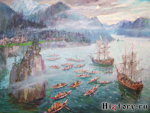
Russian travelers. Russia was becoming a great maritime power, and this put forward new tasks for domestic geographers. AT 1803-1806 was undertaken from Kronstadt to Alaska on ships "Hope" and "Neva". It was headed by Admiral Ivan Fedorovich Kruzenshtern (1770 - 1846). He commanded the ship "Hope". By ship "Neva" commanded by Captain Yuri Fedorovich Lisyansky (1773 - 1837). During the expedition, the islands of the Pacific Ocean, China, Japan, Sakhalin and Kamchatka were studied. Detailed maps of the studied places were drawn up. Lisyansky, having traveled independently from the Hawaiian Islands to Alaska, collected rich material on the peoples of Oceania and North America.
Map. The first Russian round-the-world expedition
The attention of researchers around the world has long attracted the mysterious area around the South Pole. It was assumed that there is a vast southern mainland (names "Antarctica" then it was not in use). English navigator J. Cook in the 70s of the XVIII century. crossed the Antarctic Circle, encountered impenetrable ice and declared that navigation further south was impossible. They believed him, and for 45 years no one undertook south polar expeditions.
In 1819, Russia equipped an expedition to the southern polar seas on two sloops under the leadership of Faddey Faddeevich Bellingshausen (1778 - 1852). He commanded a sloop "East". commander "Mirny" was Mikhail Petrovich Lazarev (1788 - 1851). Bellingshausen participated in the voyage of Krusenstern. Lazarev subsequently became famous as a military admiral, who brought up a whole galaxy of Russian naval commanders (Kornilov, Nakhimov, Istomin).
"East" and "Peaceful" were not adapted to polar conditions and differed greatly in seaworthiness. "Peaceful" was stronger and "East"- faster. Only thanks to the great skill of the captains, the sloops never lost each other in stormy weather and poor visibility. Several times the ships were on the verge of destruction.
But still Russian expedition managed to break through to the South much further than Cook. January 16, 1820 "East" and "Peaceful" came very close to the Antarctic coast (in the area of the present-day Bellingshausen Ice Shelf). In front of them, as far as they could see, stretched a gently rolling icy desert. Perhaps they guessed that this was the southern continent, and not solid ice. But there was no other way to obtain evidence than by landing on the shore and making a journey far into the depths of the desert. The sailors did not have such an opportunity. Therefore, Bellingshausen, a very conscientious and accurate person, reported in a report that he had seen "mainland of ice". Subsequently, geographers wrote that Bellingshausen "saw the mainland, but did not recognize it as such". And yet this date is considered the day of the discovery of Antarctica. After that, the island of Peter I and the coast of Alexander I were discovered. In 1821, the expedition returned to their homeland, having made a full voyage around the open continent.

Kostin V. "Vostok and Mirny off the coast of Antarctica", 1820
In 1811, Russian sailors led by Captain Vasily Mikhailovich Golovkin (1776-1831) explored the Kuril Islands and were taken into Japanese captivity. Golovnin's notes about his three-year stay in Japan introduced Russian society to the life of this mysterious country. Golovnin's student Fyodor Petrovich Litke (1797 - 1882) explored the Arctic Ocean, the shores of Kamchatka, South America. He founded the Russian Geographical Society, which played a big role in the development of geographical science.
Major geographical discoveries in the Russian Far East are associated with the name of Gennady Ivanovich Nevelsky (1814-1876). Rejecting the court career that opened before him, he achieved the appointment of a commander of military transport. "Baikal". He is on it in 1848-1849. sailed from Kronstadt around Cape Horn to Kamchatka, and then led the Amur expedition. He opened the mouth of the Amur, a strait between Sakhalin and the mainland, proving that Sakhalin is an island, not a peninsula.

Amur expedition of Nevelsky
Expeditions of Russian travelers, in addition to purely scientific results, were of great importance in the mutual knowledge of peoples. In distant countries, local residents often learned about Russia for the first time from Russian travelers. In turn, Russian people collected information about other countries and peoples.
Russian America
Russian America . Alaska was discovered in 1741 by the expedition of V. Bering and A. Chirikov. The first Russian settlements in the Aleutian Islands and Alaska appeared in the 18th century. In 1799, Siberian merchants engaged in crafts in Alaska united in the Russian-American Company, which was assigned a monopoly right to use the natural resources of this region. The company's board was first in Irkutsk, and then moved to St. Petersburg. The main source of income for the company was the fur trade. For many years (until 1818) the main ruler of Russian America was A. A. Baranov, a native of the merchants of the city of Kargopol, Olonets province.
The Russian population of Alaska and the Aleutian Islands was small (in different years from 500 to 830 people). In total, about 10 thousand people lived in Russian America, mostly Aleuts, inhabitants of the islands and the coast of Alaska. They willingly approached the Russians, were baptized into the Orthodox faith, adopted various crafts and clothing. The men wore jackets and frock coats, the women in cotton dresses. The girls tied their hair with a ribbon and dreamed of marrying a Russian.
Another thing is the Indians who lived in the hinterland of Alaska. They were hostile to the Russians, believing that it was they who brought into their country previously unknown diseases - smallpox and measles. In 1802, the Tlingit Indians ( "koloshey", as the Russians called them) attacked the Russian-Aleutian settlement on about. The Sitha burned everything and killed many of the inhabitants. Only in 1804 the island was recaptured. Baranov founded the Novo-Arkhangelsk fortress on it, which became the capital of Russian America. A church, a shipping yard, and workshops were built in Novo-Arkhangelsk. The library has collected more than 1200 books.
After the resignation of Baranov, the post of chief ruler began to be occupied by naval officers, inexperienced in commercial affairs. Gradually depleted fur wealth. The financial affairs of the company were shaken, she began to receive state benefits. But geographic research expanded. Especially - in the deep regions, which were indicated on the maps with a white spot.
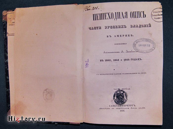
Of particular importance was the expedition of L. A. Zagoskin in 1842-1844. Lavrenty Zagoskin, a native of Penza, was the nephew of the famous writer M. Zagoskin. He described his impressions of the difficult and lengthy expedition in a book. "Pedestrian inventory of part of Russian possessions in America". Zagoskin described the basins of the main rivers of Alaska (Yukon and Kuskokwim), collected information about the climate of these areas, their natural world, and the life of the local population, with whom he managed to establish friendly relations. Written lively and talentedly, "Pedestrian description" combined scientific value and artistic merit.
I. E. Veniaminov spent about a quarter of a century in Russian America. Arriving in Novo-Arkhangelsk as a young missionary, he immediately took up the study of the Aleut language, and later wrote a textbook on its grammar. On about. Unalaska, where he lived for a long time, a church was built by his labors and care, a school and a hospital were opened. He regularly conducted meteorological and other natural observations. When Veniaminov became a monk, he was named Innocent. Soon he became the bishop of Kamchatka, the Kurils and the Aleuts.
In the 50s of the XIX century. The Russian government began to pay special attention to the study of the Amur region and the Ussuri region. Interest in Russian America has noticeably declined. she miraculously survived the capture by the British. In fact, the distant colony was and remained undefended. For the state treasury, devastated as a result of the war, the annual considerable payments of the Russian-American Company became a burden. I had to make a choice between the development of the Far East (Amur and Primorye) and Russian America. The issue was discussed for a long time, and in the end an agreement was concluded with the US government on the sale of Alaska for 7.2 million dollars. On October 6, 1867, the Russian flag was lowered in Novo-Arkhangelsk and the American flag was raised. Russia peacefully withdrew from Alaska, leaving the future generations of its inhabitants with the results of their work on its study and development.
Document: From the diary of F. F. Bellingshausen
January 10 (1821). ... At noon the wind moved to the east and became fresher. Unable to go south of the solid ice we encountered, we had to continue our journey in anticipation of a favorable wind. Meanwhile, the sea swallows gave us reason to conclude that there was a coast in the vicinity of this place.
At 3 o'clock in the afternoon they saw a blackening spot. I knew at a glance through the pipe that I was seeing the shore. The rays of the sun, emerging from the clouds, illuminated this place, and, to the general pleasure, everyone was convinced that they saw a coast covered with snow: only scree and rocks, on which the snow could not hold, turned black.
It is impossible to express in words the joy that appeared on the faces of everyone at the exclamation: “Shore! Shore!" This delight was not surprising after a long-term uniform navigation in incessant fatal dangers, between ice, in snow, rain, slush and fog ... The shore we had acquired gave us hope that there must certainly be other shores, for the existence of only one in such a vast expanse of water we thought it was impossible.
11 January. From midnight the sky was covered with thick clouds, the air was filled with darkness, the wind was fresh. We continued on the same course to the north, in order to turn and lie closer to the shore. In the course of the morning, after clearing the cloudiness that hovered over the coast, when the sun's rays illuminated it, we saw a high island, stretching from N0 61 ° to S, covered with snow. At 5 o'clock in the afternoon, having approached a distance of 14 miles from the coast, we met solid ice, which prevented us from approaching still, to better survey the coast and take something of curiosity and preservation worthy to the museum of the Admiralty Department. Having reached the very ice with the Vostok sloop, I led to the other tack to drift in order to wait for the Mirny sloop, which was behind us. As the Mirny approached, we raised our flags: Lieutenant Lazarev congratulated me via telegraph on finding the island; on both sloops they put people on the shrouds and shouted three times a mutual “hurray”. At this time it is ordered to give the sailors a glass of punch. I called Lieutenant Lazarev to me, he informed me that he saw all the ends of the coast clearly and well determined the position of them. The island was quite clearly visible, especially the lower parts, which are made up of steep stone cliffs.
I called this island the high name of the culprit for the existence of a navy in Russia - the island.
Russian pioneers of Siberia in the 17th century
Very little documentary evidence has survived about the very first explorers of the 17th century. But already from the middle of this “golden age” of the Russian colonization of Siberia, “expedition leaders” compiled detailed “skats” (that is, descriptions), a kind of reports on the routes taken, the open lands and the peoples inhabiting them. Thanks to these "tales", the country knows its heroes and the main geographical discoveries that they made.
Chronological list of Russian explorers and their geographical discoveries in Siberia and the Far East
Fedor Kurbsky
In our historical mind, the first "conqueror" of Siberia is, of course, Yermak. It became a symbol of the Russian breakthrough to the eastern expanses. But it turns out that Yermak was not the first at all. 100 (!) years before Yermak, the Moscow governors Fyodor Kurbsky and Ivan Saltykov-Travin entered the same lands with troops. They followed a path that was well known to the Novgorod "guests" and industrialists.
In general, the entire Russian north, the Subpolar Urals and the lower reaches of the Ob were considered the Novgorod patrimony, from where the enterprising Novgorodians “pumped” precious junk for centuries. And the local peoples were formally considered Novgorod vassals. Control over the vast wealth of the Northern Territories was the economic basis for the military seizure of Novgorod by Moscow. After the conquest of Novgorod by Ivan
III in 1477, not only the entire North, but also the so-called Yugra land, went to the Moscow principality.The dots show the northern route that the Russians followed to Yermak
In the spring of 1483, the army of Prince Fyodor Kurbsky climbed the Vishera, crossed the Ural Mountains, went down the Tavda, where he defeated the troops of the Pelym principality - one of the largest Mansi tribal associations in the Tavda river basin. Going further to the Tobol, Kurbsky ended up in the "Siberian Land" - that was the name of a small area in the lower reaches of the Tobol, where the Ugric tribe "Sypyr" had long lived. From here, the Russian army passed along the Irtysh to the middle Ob, where the Ugric princes successfully “fought”. Having collected a large yasak, the Moscow detachment turned back, and on October 1, 1483, Kurbsky's squad returned to their homeland, having covered about 4.5 thousand kilometers during the campaign.
The results of the campaign were the recognition in 1484 by the "princes" of Western Siberia of dependence on the Grand Duchy of Moscow and the annual payment of tribute. Therefore, starting from Ivan III, the titles of the Grand Dukes of Moscow (later transferred to the royal title) included the words " Grand Duke Yugorsky, Prince Udorsky, Obdorsky and Kondinsky.
Vasily Suk and n
He founded the city of Tyumen in 1586. On his initiative, the city of Tobolsk was founded (1587). Ivan Suk and he was not a pioneer. He was a high-ranking Moscow rank, governor, sent with a military detachment to help Yermakov's army to "finish off" Khan Kuchum. He laid the foundation for the capital arrangement of Russians in Siberia.
Cossack Penda
Discoverer of the Lena River. Mangazeya and Turukhansky Cossack, a legendary figure. He came out with a detachment of 40 people from Mangazeya (a fortified prison and the most important trading point of Russians in North-Western Siberia (1600-1619) on the Taz River). This man made a campaign, unprecedented in its determination, thousands of miles across completely wild places. Legends about Penda were passed from mouth to mouth among the Mangazeya and Turukhansk Cossacks and fishermen, and came to historians in almost their original form.
Penda with like-minded people went up the Yenisei from Turukhansk to the Lower Tunguska, then for three years he walked to its upper reaches. I got to the Chechuy portage, where Lena comes very close to the Lower Tunguska. What next, crossed the portage, he sailed down the Lena River to the place where the city of Yakutsk was later built: from where he continued his way along the same river to the mouth of the Kulenga, then along the Buryat steppe to the Angara, where, embarking on ships, through the Yeniseisk, the packs arrived in Turukhansk».
Petr Beketov
Sovereign's service man, voivode, explorer of Siberia. Founder of a number of Siberian cities such as Yakutsk, Chita, Nerchinsk. He came to Siberia voluntarily (he asked to be sent to the Yenisei jail, where he was appointed a shooter centurion in 1627). Already in 1628-1629 he participated in the campaigns of the Yenisei service people up the Angara. He walked a lot along the tributaries of the Lena, collected yasak, brought the local population under Moscow's control. He founded several sovereign jails on the Yenisei, Lena and in Transbaikalia.

Ivan Moskvitin
The first of the Europeans went to the Sea of Okhotsk. The first to visit Sakhalin. Moskvitin began his service in 1626 as an ordinary Cossack of the Tomsk prison. He probably participated in the campaigns of Ataman Dmitry Kopylov to the south of Siberia. In the spring of 1639 he set off from Yakutsk to the Sea of Okhotsk with a detachment of 39 servicemen. The goal was the usual one - "the mine of new lands" and new obscure (that is, not yet taxed) people. Moskvitin's detachment went down the Aldan to the Mai River and seven weeks went up the May, six days went from May to the portage by a small river, they went one day by portage and reached the Ulya river, eight days went down the Ulya with a plow, then, having made a boat to the sea, sailed for five days.
Results of the campaign: The coast of the Sea of Okhotsk was discovered and explored for 1300 km, the Uda Bay, Sakhalin Bay, the Amur Estuary, the mouth of the Amur and Sakhalin Island. In addition, they brought with them to Yakutsk a large prey in the form of fur yasak.

Ivan Stadukhin
The discoverer of the Kolyma River. He founded the Nizhnekolymsky prison. He explored the Chukotka Peninsula and was the first to enter the north of Kamchatka. Passed on the cochs along the coast and described one and a half thousand kilometers of the northern part of the Sea of Okhotsk. He kept records of his "circular" trip, described and drew up a drawing-map of the places of Yakutia and Chukotka, where he visited.
Semyon Dezhnev
Cossack chieftain, explorer, traveler, navigator, explorer of Northern and Eastern Siberia, as well as a fur trader. Participated in the opening of Kolyma as part of the detachment of Ivan Stadukhin. From Kolyma, on horseback, he traveled across the Arctic Ocean along the northern coast of Chukotka. 80 years before Vitus Bering, the first European in 1648 crossed the (Bering) Strait separating Chukotka and Alaska. (It is noteworthy that V. Bering himself did not manage to go through the entire strait, but had to confine himself to only its southern part!

Vasily Poyarkov
Russian explorer, Cossack, explorer of Siberia and the Far East. The discoverer of the Middle and Lower Amur. In 1643 46 he led a detachment that was the first Russian to penetrate the Amur River basin and discover the Zeya River and the Zeya Plain. Gathered valuable information about the nature and population of the Amur region
1649-1653
Erofei Khabarov
A Russian industrialist and entrepreneur, he traded furs in Mangazeya, then moved to the upper reaches of the Lena, where from 1632 he was engaged in buying up furs. In 1639, he discovered salt springs on the Kut River and built a vat, and then contributed to the development of agriculture there.
In 1649-53, with a detachment of eager people, he made a trip along the Amur from the confluence of the Urka River into it to the very lower reaches. As a result of his expedition, the Amur indigenous population accepted Russian citizenship. He often acted by force, which left a bad reputation among the indigenous population. Khabarov compiled a “Drawing on the Amur River”. The Khabarovka military post founded in 1858 (since 1893 - the city of Khabarovsk) and the railway station Erofey Pavlovich (1909) are named after Khabarov.

Vladimir Atlasov
Cossack Pentecostal, clerk of the Anadyr prison, "an experienced polar explorer", as they would say now. Kamchatka was, one might say, his goal and dream. The Russians already knew about the existence of this peninsula, but none of them had yet penetrated the territory of Kamchatka.  Atlasov, using borrowed money, at his own risk organized an expedition to explore Kamchatka in early 1697. Taking an experienced Cossack Luka Morozko, who had already been in the north of the peninsula, into the detachment, he set out from the Anadyr prison to the south. The purpose of the campaign was traditional - furs and the accession of new "unclaimed" lands to the Russian state.
Atlasov was not the discoverer of Kamchatka, but he was the first Russian who traveled almost the entire peninsula from north to south and from west to east. He compiled a detailed "tale" and a map of his journey. His report contained detailed information about the climate, flora and fauna, as well as the amazing sources of the peninsula. He managed to persuade a significant part of the local population to come under the authority of the Moscow Tsar.
For the annexation of Kamchatka to Russia, Vladimir Atlasov, by decision of the government, was appointed there as a clerk. The campaigns of V. Atlasov and L. Morozko (1696-1699) were of great practical importance. These people discovered and annexed Kamchatka to the Russian state, laid the foundation for its development. The government of the country, represented by Tsar Peter Alekseevich, already then understood the strategic importance of Kamchatka for the country and took measures to develop it and consolidate it on these lands.
Russian travelers and pioneers
Again
Travelers of the Age of DiscoveryPreface.
The 19th century is the century of exploration of the inner parts of the continents. The expeditions of the great Russian travelers Semyonov Tyan-Shansky, Przhevalsky and many others, who discovered the mountainous and desert regions of Central Asia, became especially famous. Based on the results of the research of these expeditions, multi-volume publications were published with detailed descriptions of different countries. Travelers' diaries were read in the houses of the intelligentsia and high-society salons. In the XIX century, the Earth becomes more and more habitable and studied planet.
Pyotr Semyonov Tien-Shansky (1827-1914)
In the middle of the 19th century, little was known about the mountain range called Inner Asia. "Heavenly mountains" - Tien Shan - were mentioned only in scarce Chinese sources. 27 year old Pyotr Semyonov was already quite well known in scientific circles. He made a great trip to European Russia, was the secretary of the Department of Physical Geography of the Russian Geographical Society, translated into Russian the work of the German geographer Carl Ritter "Geography of Asia".
European explorers have long been planning a trip to the Tien Shan. The great Alexander Humboldt also dreamed of this. Conversations with Humboldt finally strengthened the decision of Peter Semyonov to go to the “Celestial Mountains”.
The expedition required careful preparation, and only at the end of August 1858 did Semyonov and his companions reach Fort Verny (now Alma-Ata). It was already too late to go to the mountains, and therefore the travelers decided to make a hike to the shores of Lake Issyk-Kul. On one of the passes in front of them, a majestic panorama of the Central Tien Shan unfolded. A continuous chain of mountain peaks seemed to grow out of the blue waters of the lake. No European has yet seen her. Thanks to Semenov, the exact outlines of the lake were for the first time put on a geographical map. Winter and spring flew by quickly. Semyonov processed botanical and geological collections, prepared for a new journey. Returning to the eastern shore of Issyk-Kul, on June 21, 1857, with a large detachment of 48 Cossacks and 12 local residents, he set off on an unknown path along the Tien Shan.
This expedition, perhaps, was unique in the entire history of geographical discoveries. It lasted less than three months, but its results are downright amazing. "Heavenly Mountains" have lost their halo of mystery.
Already on the fourth day of the trip, the travelers saw Khan Tengri. For a long time, this peak was considered the highest point of the Tien Shan (6995 m). Only in 1943, topographers established that the peak, 20 km away from Khan Tengri, had a high height (7439 m). It was called the peak of Victory.
His contemporaries were shocked by the abundance of discoveries that were the result of the expedition.
The dry statistics speak for themselves. 23 mountain passes were surveyed, the heights of 50 peaks were determined; collected 300 rock samples, collections of insects and molluscs, 1000 specimens of plants (many of them were unknown to science). Vegetation zones are described in detail; this description made it possible to draw such a vivid botanical-geographical picture that later it remained only to make separate touches and additions to it. In addition, two transverse geological sections of the Tien Shan were further obtained, which helped a deeper study of the geology of Central Asia.
And that's not all. It was possible to determine the height of the Tien Shan snow line, to establish the existence of alpine-type glaciers, and, finally, to refute Humboldt's idea of Tien Shan volcanism.
Semyonov understood that everything he had seen during the summer of 1857 was only the beginning of extensive research, and several more expeditions would be needed to comprehensively study the Heavenly Mountains.
He only did not know, leaving Verny in mid-September of the same year, that he was saying goodbye to them forever. So his further fate developed that he never again had to admire the majestic Khan-Tengri.
Returning to St. Petersburg, Semenov submitted to the Geographical Society a plan for a new expedition to the Tien Shan, which he intended to make in 1860-1861. However, the vice-chairman of the society, F. P. Litke, told him that there were no funds for equipping the expedition and “it would hardly be possible to obtain permission for it.” Quite unexpectedly for himself, in February 1859 Semyonov was appointed head of the editorial commissions for preparations for the peasant reform.
The following is a cursory list of those acts that Semyonov carries out. He actively participates in the preparation for publication of the map of European Russia and the Caucasus. Edits the fundamental “Geographical and Statistical Dictionary” and writes the most important articles for it. He is developing a draft of the All-Russian population census (it took place in 1897). In essence, he becomes the founder of the economic geography of Russia. When he manages to find time, he makes short excursions to different parts of the country. Fascinated by entomology, he collects a collection of beetles: by the end of his life, it numbered 700,000 specimens and was the largest in the world.
For almost half a century, Semyonov headed the Russian Geographical Society. Under his leadership, it became a true "headquarters" of geographical research conducted by Russian travelers - Kropotkin, Potanin, Przhevalsky, Obruchev and others. Semyonov developed routes and expedition programs, sought their material support. He completed his life as a world famous scientist. More than 60 academies and scientific institutions in Europe and Russia have elected him as their member and honorary member. His name is immortalized in 11 geographical names in Asia, North America and Svalbard, and one of the peaks of the Mongolian Altai bears the name "Pyotr Petrovich".
Accidental pneumonia brought Semyonov Tyan-Shansky to the grave on February 26, 1914 at the age of 87. Contemporaries recalled that his amazing creative energy, clarity of mind and phenomenal memory did not betray him until the very last days.
Of his many awards, he was most proud of the Karl Ritter medal awarded to him by the Berlin Geographical Society in 1900. It was made from silver. The only time the medal was minted from gold was when it was intended for Semyonov Tyan-Shansky ...
Nikolai Przhevalsky (1839-1888)
The blow of fate was unexpected and insidious: at the very beginning of the next expedition to Central Asia, the explorer Nikolai Przhevalsky, languishing with thirst, drank water from a natural stream - and now he, a man of iron health, was dying in the arms of his comrades from typhoid fever on the shores of Lake Issyk -Kul.
He was at the zenith of his fame: 24 scientific institutions in Russia and Europe elected him their honorary member, geographical societies of many countries awarded him their highest awards. Presenting him with a gold medal, British geographers compared
his travels with those of the famous Marco Polo.
During his wandering life, he traveled 35,000 km, a little short of the length of the equator.
And so he died...
Przhevalsky dreamed of wanderings from an early age and stubbornly prepared for them. But the Crimean War broke out - he went as a private in the army. And then years of study at the Academy of the General Staff. However, a military career did not attract him at all. Staying at the Academy was marked for Przhevalsky only by compiling the Military Statistical Review of the Amur Territory.
Nevertheless, this work allowed him to become a member of the Geographical Society.
In early 1867, Przhevalsky submitted to the Society a plan for a major and risky expedition to Central Asia. However, the audacity of the young officer seemed excessive, and the matter was limited to his business trip to the Ussuri Territory with permission to "conduct any kind of scientific research." But Przhevalsky met this decision with enthusiasm.
In this first trip, Przhevalsky compiled the most complete description of the Ussuri region and gained valuable expeditionary experience. Now they believed in him: there were no obstacles for traveling to Mongolia and the country of the Tanguts - Northern Tibet, which he dreamed about.
During the four years of the expedition (1870 - 1873) it was possible to make significant amendments to the geographical map.
In 1876, he again sets a course for Tibet. Przhevalsky was the first European to reach the mysterious Lobnor Lake, discover the previously unknown Altyndag Range and determine the exact border of the Tibetan Plateau, establishing that it begins 300 km north of what was previously thought. But this time he failed to penetrate into the depths of this country, almost unknown to Europeans.
And yet, three years later, the Russian explorer reached the coveted highlands. The absolute lack of exploration of this area attracted Przhevalsky, who sent here in the early 1880s. your expedition. It was his most fruitful journey, crowned with many discoveries. True, Przhevalsky did not succeed in discovering the source of the Huang He (it was found only quite recently), however, the Russian expedition studied in detail the watershed between the Yellow River - the Yellow River and the largest Blue River in China and Eurasia - the Yangtze. Previously unknown ridges were plotted on the map. Przhevalsky gave them names: Columbus Ridge, Moscow Ridge, Russian Ridge. He called one of the peaks of the latter the Kremlin. Subsequently, a ridge appeared in this mountain system, perpetuating the name of Przhevalsky himself.
Processing the results of this expedition took a long time and was completed only in March 1888.
In the course of all his expeditions, Przhevalsky, being a professional geographer, made discoveries that could bring fame to any zoologist or botanist. He described a wild horse (Przewalski's horse), a wild camel and a Tibetan bear, several new species of birds, fish and reptiles, hundreds of species of plants...
And he was on his way again. Tibet again beckoned him to itself. This time, Przhevalsky firmly decided to visit Lhasa.
But all plans collapsed. He was dying in his tent, barely starting the journey. Before his death, he asked his companions to bury him “certainly on the shore of Issyk-Kul, in a marching expeditionary uniform…”.
November 1, 1888 Nikolai Mikhailovich Przhevalsky died. His last request was granted.
On the monument to Przhevalsky there is an inscription: "The first researcher of the nature of Central Asia." And ten steps cut in the rock lead to this inscription. Ten - according to the number of expeditions undertaken by a remarkable traveler, including the last one, interrupted so tragically.
