The Andes is the longest (9000 km) and one of the highest (Mount Aconcagua, 6962 m) mountain systems of the Earth, bordering all of South America from the north and west; southern part of the Cordillera. In some places, the Andes reach a width of over 500 km (the greatest width - up to 750 km - in the Central Andes, between 18 ° and 20 ° S). The average height is about 4000 m. The Andes are a major interoceanic watershed; to the east of the Andes flow the rivers of the Atlantic Ocean basin (the Amazon itself and many of its large tributaries originate in the Andes, as well as the tributaries of the Orinoco, Paraguay, Parana, the Magdalena River and the Patagonian rivers), to the west - the rivers of the Pacific Ocean basin (mostly short). The Andes serve as the most important climatic barrier in South America, isolating the territories to the west of the Cordillera Main from the influence of the Atlantic Ocean, to the east - from the influence of the Pacific Ocean. The mountains lie in 5 climatic zones (equatorial, subequatorial, tropical, subtropical and temperate) and are distinguished (especially in the central part) by sharp contrasts in the moistening of the eastern (leeward) and western (windward) slopes.
Due to the considerable length of the Andes, their individual landscape parts differ significantly from each other. By the nature of the relief and other natural differences, as a rule, three main regions are distinguished - the Northern, Central and Southern Andes.
The Andes stretched through the territories of seven states of South America - Venezuela, Colombia, Ecuador, Peru, Bolivia, Chile and Argentina.
According to the Italian historian Giovanni Anello Oliva (1631), the eastern ridge was originally called the "Andes or Cordilleras" ("Andes, o cordilleras") by the European conquerors, while the western one was called the "sierra" ("sierra"). Currently, most scientists believe that the name comes from the Quechuan word anti (high ridge, ridge), although there are other opinions.
Geological structure and relief
Andes - revived mountains erected by the latest uplifts on the site of the so-called Andean (Cordillera) folded geosynclinal belt; The Andes are one of the largest Alpine folding systems on the planet (on the Paleozoic and partly Baikal folded basement). The formation of the Andes dates back to the Jurassic. The Andean mountain system is characterized by troughs formed in the Triassic, subsequently filled with layers of sedimentary and volcanic rocks of considerable thickness. Large massifs of the Main Cordillera and the coast of Chile, the Coastal Cordillera of Peru are Cretaceous granitoid intrusions. Intermountain and marginal troughs (Altiplano, Maracaibo, etc.) formed in the Paleogene and Neogene times. Tectonic movements, accompanied by seismic and volcanic activity, continue in our time. This is due to the fact that a subduction zone passes along the Pacific coast of South America: the Nazca and Antarctic plates go under the South American one, which contributes to the development of mountain building processes. The extreme southern part of South America, Tierra del Fuego, is separated by a transform fault from the small Scotia plate. Beyond the Drake Passage, the Andes continue the mountains of the Antarctic Peninsula.
The Andes are rich in ores, mainly of non-ferrous metals (vanadium, tungsten, bismuth, tin, lead, molybdenum, zinc, arsenic, antimony, etc.); the deposits are confined mainly to the Paleozoic structures of the eastern Andes and the vents of ancient volcanoes; in Chile - large copper deposits. There is oil and gas in the forward and foothill troughs (in the foothills of the Andes within Venezuela, Peru, Bolivia, Argentina), and in the weathering crusts - bauxites. In the Andes there are also deposits of iron (in Bolivia), sodium nitrate (in Chile), gold, platinum and emeralds (in Colombia).
The Andes consist mainly of meridional parallel ranges: the Eastern Cordillera of the Andes, the Central Cordillera of the Andes, the Western Cordillera of the Andes, the Coastal Cordillera of the Andes, between which lie internal plateaus and plateaus (Puna, Altiplano - in Bolivia and Peru) or depressions. The width of the mountain system is mainly 200-300 km.


Orography
Northern Andes
The main system of the Andes mountains (Andean Cordillera) consists of parallel ridges stretching in the meridional direction, separated by internal plateaus or depressions. Only the Caribbean Andes, located within Venezuela and belonging to the Northern Andes, stretch sublatitudinally along the coast of the Caribbean Sea. The northern Andes also include the Ecuadorian Andes (in Ecuador) and the Northwestern Andes (in western Venezuela and Colombia). The highest ridges of the Northern Andes have small modern glaciers, and eternal snows on volcanic cones. The islands of Aruba, Bonaire, Curaçao in the Caribbean are the peaks of the continuation of the Northern Andes descending into the sea.
In the Northwestern Andes, fan-shaped diverging north of 12 ° N. sh., there are three main Cordillera - Eastern, Central and Western. All of them are high, steeply sloping and have a folded-block structure. They are characterized by faults, uplifts and subsidences of modern times. The main Cordilleras are separated by large depressions - the valleys of the rivers Magdalena and Cauca - Patia.
The Eastern Cordillera has its highest altitude in its northeastern part (Mount Ritakuwa, 5493 m); in the center of the Eastern Cordillera - an ancient lake plateau (the prevailing heights are 2.5 - 2.7 thousand m); the Eastern Cordillera is generally characterized by large leveling surfaces. In the highlands there are glaciers. In the north, the Eastern Cordillera is continued by the Cordillera de Merida (the highest point is Mount Bolivar, 5007 m) and the Sierra de Perija (reaches a height of 3,540 m); between these ridges in a vast low-lying depression lies Lake Maracaibo. In the far north - the Sierra Nevada de Santa Marta horst massif with altitudes up to 5800 m (Mount Cristobal Colon)
The valley of the Magdalena River separates the Eastern Cordillera from the Central, relatively narrow and high; in the Central Cordillera (especially in its southern part) there are many volcanoes (Huila, 5750 m; Ruiz, 5400 m; and others), some of them are active (Kumbal, 4890 m). To the north, the Central Cordillera drops somewhat and forms the Antioquia massif, strongly dissected by river valleys. The Western Cordillera, separated from the Central Valley of the Cauca River, has lower altitudes (up to 4200 m); in the south of the Western Cordillera - volcanism. Further to the west is the low (up to 1810 m) Serraniu de Baudo ridge, which passes in the north into the mountains of Panama. North and west of the Northwest Andes are the Caribbean and Pacific alluvial lowlands.
As part of the Equatorial (Ecuadorian) Andes, reaching up to 4 ° S, there are two Cordilleras (Western and Eastern), separated by depressions 2500-2700 m high. Along the faults that limit these depressions (depressions) - one of the highest volcanic chains (the highest volcanoes are Chimborazo, 6267 m, Cotopaxi, 5897 m). These volcanoes, as well as those of Colombia, form the first volcanic region of the Andes.
Central Andes
In the Central Andes (up to 28 ° S), the Peruvian Andes (spreading south to 14 ° 30′ S) and the Central Andes proper are distinguished. In the Peruvian Andes, as a result of recent uplifts and intensive incision of rivers (the largest of which - Marañon, Ucayali and Huallaga - belong to the system of the upper Amazon), parallel ridges (Eastern, Central and Western Cordillera) and a system of deep longitudinal and transverse canyons were formed, dismembering the ancient leveling surface . The peaks of the Cordillera of the Peruvian Andes exceed 6000 m (the highest point is Mount Huascaran, 6768 m); in Cordillera Blanca - modern glaciation. Alpine landforms are also developed on the blocky ridges of the Cordillera Vilcanota, Cordillera de Vilcabamba, Cordillera de Carabaia. To the south is the widest part of the Andes - the Central Andean Highlands (up to 750 km wide), where arid geomorphological processes predominate; a significant part of the highlands is occupied by the Puna plateau with heights of 3.7 - 4.1 thousand m. Puna is characterized by drainless basins (“bolsons”) occupied by lakes (Titicaca, Poopo, etc.) and salt marshes (Atacama, Koipasa, Uyuni, etc. .). To the east of Pune - Cordillera Real (Ankouma peak, 6550 m) with powerful modern glaciation; between the Altiplano plateau and the Cordillera Real, at an altitude of 3700 m, is the city of La Paz, the capital of Bolivia, the highest mountain in the world. East of the Cordillera Real - Subandian folded ranges of the Eastern Cordillera, reaching up to 23 ° S. The southern continuation of the Cordillera Real is the Central Cordillera, as well as several blocky massifs (the highest point is Mount El Libertador, 6720 m). From the west, Pune is framed by the Western Cordillera with intrusive peaks and numerous volcanic peaks (Sahama, 6780 m; Lullaillaco, 6739 m; San Pedro, 6145 m; Misti, 5821 m; etc.), which are part of the second volcanic region of the Andes. South of 19° S the western slopes of the Western Cordillera go to the tectonic depression of the Longitudinal Valley, occupied in the south by the Atacama Desert. Behind the Longitudinal Valley there is a low (up to 1500 m) intrusive Coastal Cordillera, which is characterized by arid sculptural relief forms.
In Pune and in the western part of the Central Andes there is a very high snow line (in some places above 6,500 m), therefore, snow is noted only on the highest volcanic cones, and glaciers are found only in the Ojos del Salado massif (up to 6,880 m high).
Southern Andes
In the Southern Andes, extending south of 28 ° S, there are two parts - the northern (Chile-Argentine, or Subtropical Andes) and the southern (Patagonian Andes). In the Chilean-Argentinean Andes, tapering to the south and reaching 39 ° 41′ S, a three-membered structure is pronounced - the Coastal Cordillera, the Longitudinal Valley and the Main Cordillera; within the latter, in the Cordillera Frontal, there is the highest peak of the Andes, Mount Aconcagua (6960 m), as well as the large peaks of Tupungato (6800 m), Mercedario (6770 m). The snow line here is very high (at 32°40′ S - 6000 m). East of the Cordillera Frontal are the ancient Precordillera.
South of 33°S (and up to 52 ° S) the third volcanic region of the Andes is located, where there are many active (mainly in the Main Cordillera and to the west of it) and extinct volcanoes (Tupungato, Maypa, Lyimo, etc.)
When moving south, the snow line gradually decreases and under 51 ° S.l. reaches a mark of 1460 m. High ridges acquire the features of an alpine type, the area of \u200b\u200bmodern glaciation increases, and numerous glacial lakes appear. South of 40°S the Patagonian Andes begin with lower ridges than in the Chilean-Argentine Andes (the highest point is Mount San Valentin - 4058 m) and active volcanism in the north. About 52° S the heavily dissected Coastal Cordillera plunges into the ocean, and its peaks form a chain of rocky islands and archipelagos; The longitudinal valley turns into a system of straits reaching the western part of the Strait of Magellan. In the area of the Strait of Magellan, the Andes (here called the Andes of Tierra del Fuego) deviate sharply to the east. In the Patagonian Andes, the height of the snow line barely exceeds 1500 m (in the extreme south it is 300-700 m, and from 46 ° 30′ S. glaciers descend to ocean level), glacial landforms predominate (below 48 ° S - powerful Patagonian ice sheet) with an area of over 20 thousand km², from where many kilometers of glacial tongues descend to the west and east); some of the valley glaciers on the eastern slopes end in large lakes. Young volcanic cones (Corcovado and others) rise along the shores, strongly indented by fjords. The Andes of Tierra del Fuego are relatively low (up to 2469 m).


Vegetation and soils
The soil and vegetation cover of the Andes is very diverse. This is due to the high altitudes of the mountains, a significant difference in the moisture content of the western and eastern slopes. Altitudinal zonality in the Andes is clearly expressed. There are three altitudinal belts - tierra caliente, tierra fria and tierra elada.
In the Andes of Venezuela, deciduous (during the winter drought) forests and shrubs grow on red mountainous soils. The lower parts of the windward slopes from the northwestern Andes to the Central Andes are covered with mountainous equatorial and tropical forests on lateritic soils, as well as mixed forests of evergreen and deciduous species. The external appearance of the equatorial forests differs little from the external appearance of these forests in the flat part of the mainland; various palms, ficuses, bananas, a cocoa tree, etc. are characteristic. Higher (up to altitudes of 2500-3000 m), the nature of the vegetation changes; Bamboos, tree ferns, coca shrub (which is the source of cocaine), cinchona are typical. Between 3000 m and 3800 m - alpine hylaea with stunted trees and shrubs; epiphytes and creepers are widespread, bamboos, tree-like ferns, evergreen oaks, myrtle, heather are characteristic. Above - predominantly xerophytic vegetation, paramos, with numerous Compositae; moss swamps on flat areas and lifeless rocky spaces on steep slopes. Above 4500 m - a belt of eternal snow and ice.
To the south, in the subtropical Chilean Andes - evergreen shrubs on brown soils. In the Longitudinal Valley there are soils resembling chernozems in composition. The vegetation of the alpine plateaus: in the north - mountain equatorial meadows of paramos, in the Peruvian Andes and in the east of Pune - dry alpine-tropical steppes of halka, in the west of Pune and in the entire Pacific west between 5-28 ° south latitude - desert types of vegetation (in the Atacama Desert - succulent vegetation and cacti). Many surfaces are saline, which hinders the development of vegetation; in such areas, mainly wormwood and ephedra are found. Above 3000 m (up to about 4500 m) - semi-desert vegetation, called dry puna; grow dwarf shrubs (tholoi), grasses (feather grass, reed grass), lichens, cacti. To the east of the Main Cordillera, where there is more rainfall, there is steppe vegetation (puna) with numerous grasses (fescue, feather grass, reed grass) and cushion-shaped shrubs. On the humid slopes of the Eastern Cordillera, tropical forests (palm trees, cinchona) rise to 1500 m, stunted evergreen forests with a predominance of bamboo, ferns, and lianas reach 3000 m; at higher altitudes - alpine steppes. A typical inhabitant of the Andean highlands is polylepis, a plant of the Rosaceae family, common in Colombia, Bolivia, Peru, Ecuador and Chile; these trees are also found at an altitude of 4500 m.
In the middle part of Chile, the forests are largely reduced; once forests rose along the Main Cordillera to heights of 2500-3000 m (mountain meadows with alpine grasses and shrubs, as well as rare peat bogs, began higher), but now the mountain slopes are practically bare. Nowadays, forests are found only in the form of separate groves (pines, araucaria, eucalyptus, beeches and plane trees, in the undergrowth - gorse and geraniums). On the slopes of the Patagonian Andes south of 38°S. - subarctic multi-tiered forests of tall trees and shrubs, mostly evergreen, on brown forest (podzolized to the south) soils; there are many mosses, lichens and lianas in the forests; south of 42°S - mixed forests (in the region of 42 ° S there is an array of araucaria forests). Beeches, magnolias, tree ferns, tall conifers, and bamboos grow. On the eastern slopes of the Patagonian Andes - mostly beech forests. In the extreme south of the Patagonian Andes - tundra vegetation.
In the extreme southern part of the Andes, on Tierra del Fuego, forests (from deciduous and evergreen trees - for example, southern beech and canelo) occupy only a narrow coastal strip in the west; above the forest border, the snow belt begins almost immediately. In the east and in places in the west, subantarctic mountain meadows and peat bogs are common.
The Andes are the birthplace of cinchona, coca, tobacco, potatoes, tomatoes and other valuable plants.
Animal world
The fauna of the northern part of the Andes is part of the Brazilian zoogeographic region and is similar to the fauna of the adjacent plains. The fauna of the Andes south of 5 ° south latitude belongs to the Chilean-Patagonian subregion. The fauna of the Andes as a whole is characterized by an abundance of endemic genera and species. The Andes is inhabited by llamas and alpacas (representatives of these two species are used by the local population for obtaining wool and meat, as well as pack animals), chain-tailed monkeys, a relic spectacled bear, pudu and gaemal deer (which are endemic to the Andes), vicuña, guanaco, Azar fox , sloths, chinchillas, marsupial opossums, anteaters, degu rodents. In the south - blue fox, Magellanic dog, endemic rodent tuco-tuco, etc. There are many birds, among them hummingbirds, which are also found at altitudes of more than 4000 m, but are especially numerous and diverse in the "foggy forests" (moist tropical forests of Colombia, Ecuador , Peru, Bolivia and the extreme northwest of Argentina, located in the fog condensation zone); endemic condor, rising to a height of up to 7 thousand meters; and others. Some species (such as, for example, chinchillas, which were intensively exterminated in the 19th and early 20th centuries for the sake of obtaining skins; wingless grebes and the Titicaca whistler, found only near Lake Titicaca; etc.) are endangered.
A feature of the Andes is a large species diversity of amphibians (over 900 species). Also in the Andes, there are about 600 species of mammals (13% are endemic), over 1,700 species of birds (of which 33.6% are endemic) and about 400 species of freshwater fish (34.5% are endemic)
Information
- Countries: Venezuela, Colombia, Ecuador, Peru, Bolivia, Chile, Argentina
- Length: 9000 km
- Width: 500 km
- highest peak: Aconcagua
Source. wikipedia.org
Many are interested in where the Andes are located: on which mainland, in which climatic zones, on the territory of which states. Also, some readers would like to know about the time of origin of these great mountains, their nature and population. All this will be discussed in this article.
Geographical position
The Andes is the longest mountain system in the world. It borders the north and west of South America and extends for 9000 km. The width of the mountains is no less impressive: an average of about 500, and a maximum of 750 km.
The Andean Cordillera, as this mountain system is also called, is a natural barrier separating the territory of South America from the Atlantic. This is also a large watershed: the rivers of the Atlantic Ocean basin flow from the eastern side, and the Pacific from the western. High in the mountains, the tributaries of the Amazon, Orinoco, Paraguay, Parana, as well as many water arteries of Patagonia, originate.
The territory of the Andes covers seven countries of South America: Venezuela, Peru, Bolivia, Chile, Colombia, Argentina, Ecuador.
Weather
Owing to their vast extent, the ridges and spurs of these great mountains spread over several climatic zones.
The northern Andes are dominated by subequatorial latitudes with a clear alternation of rainy and dry seasons.
The tropical zone is characterized by constant values of both temperature and humidity: there are no sharp changes here. These are the conditions in the Caribbean Andes. There is also no seasonality at the equator, but climate differences in height are pronounced: at the foot - it is humid and hot, at the peaks - snow.

The central part is characterized by a division along the slopes: an order of magnitude less precipitation falls from the west than from the east. Here is a zone of tropical deserts with frequent fogs and dews. The average annual temperature on the Puna and Altiplano plateaus does not exceed 10 ° C, and the conditions here are harsh: a sharp change in weather and strong gusty winds are the norm.
In the south, in the region of Tierra del Fuego, a humid oceanic climate prevails. The annual rainfall exceeds 3,000 mm. They fall mainly in the form of a nasty drizzle that does not stop most of the days of the year.
How did they form?
Where the Andes are located, any student can show on the physical map of the world. A complex chain of parallel ridges formed over millions of years. According to scientists, the Andes mountain system, where the subduction zone is located, is being transformed and is still being transformed. The Antarctic tectonic plate and Nazca are gradually moving under the South American one.
Geologists at the University of Bristol have established an approximate time for the start of the uplift of the mountains. They used a new modern method, which is based on the study of cosmogenic helium-3, which is formed in mineral layers under the influence of cosmic radiation.

British scientists analyzed stones at an altitude of about 2 km in the western part of the mountain range. After numerous studies, they came to the conclusion that the Andes, where these boulders are located, were about the same level as they are now 15 million years ago. The slopes gradually rise due to the thickening of the earth's crust at the point of contact of the lithospheric plates.
The mainland, where the Andes mountains are located, is still in constant motion. This is imperceptible to us, however, when powerful earthquakes and volcanic eruptions occur, the planet reminds us of the processes taking place in its womb.
Vegetable world
The flora of these places directly depends on the altitudinal zonality. The Caribbean Andes are characterized by deciduous forests and shrubs. The eastern slopes are covered with impenetrable tropical jungles, while deserts and dry cereal steppe regions are located in the west. In the highlands of the equatorial latitudes, meadows predominate.

The Andes, where the lands are so diverse in terms of moisture and temperature, are considered the birthplace of many cultivated plants, including potatoes, coca and cinchona, which from time immemorial served as a powerful treatment for malaria.
Animal world
The fauna of the mountainous regions is similar to the adjacent plains. Among the endemics, vicuñas and guanacos, spectacled bears, chinchillas, the Chilean opossum, Azarov's fox, Magellanic dog should be abolished.

The Andes, where there are 88 national parks, is home to many birds. In mountainous areas one can meet condors, partridges, hummingbirds, several species of geese and ducks, flamingos and parrots.
highest point
Aconcagua is the highest extinct volcano in the world. This mountain peak, located in the central part of the Andes on the territory of modern Argentina, is the highest not only in its system, but also on the entire continent, as well as in the Southern and Western Hemispheres.

The name of the peak, according to one version, comes from the ancient Quechua language and is translated as “stone guard”.
From the point of view of mountaineering, Aconcagua is a fairly easy peak to climb, especially its northern slope. The shortest time for which you can climb up (6962 m) was recorded in 1991 and amounted to 5 hours and 45 minutes.
The first person to climb the Stone Guard was the Swiss Matthias Zurbriggen. It happened on January 14, 1897 as part of the expedition of the Englishman Edward Fitzgerald.
The Incas - the ancient inhabitants of the mountains
The vanished civilization of the Incas lived in these mountainous regions many millennia ago. It was they who gave the name Andes. Translated from their ancient language, “anta” means “copper mountains”. And this name is not accidental: the largest belt with the richest deposits of this metal is located here.
Numerous tourists climb high into the Andes, where the cultural monuments of this mysterious civilization that have survived to this day are located.
The most famous cult place is a complex of structures called Machu Picchu, lost among the endless canyons and rocks. The sacred monastery of the ancient people was erected on the top of a ridge located at an altitude of 2.5 km above sea level. And although in translation its name sounds like “old peak”, the Incas called Machu Picchu “the city in the clouds”.

In 1532, when the Spaniards came to the lands belonging to the Incas, the city was mysteriously empty. Where the inhabitants of Machu Picchu disappeared is still unknown. According to one of the legends, a huge cloud covered the city, taking the Indians with them.
Andes, Andean Cordillera(Spanish) Andes; Cordillera de los Andes ) - the longest (9000 km) and one of the highest (Mount Aconcagua, 6962 m) mountain systems of the Earth, bordering all of South America from the north and west; southern part of the Cordillera. In some places, the Andes reach a width of over 500 km (the greatest width - up to 750 km - in the Central Andes, between 18 ° and 20 ° S). The average height is about 4000 m.
The Andes is a major interoceanic divide; to the east of the Andes, the rivers of the Atlantic Ocean basin flow (the Amazon itself and many of its large tributaries originate in the Andes, as well as the tributaries of the Orinoco, Paraguay, Parana, the Magdalena River and the Patagonia River), to the west - the Pacific Ocean basin (mostly short).
The Andes serve as the most important climatic barrier in South America, isolating the territories to the west of the Cordillera Main from the influence of the Atlantic Ocean, to the east - from the influence of the Pacific Ocean. The mountains lie in 5 climatic zones (equatorial, subequatorial, tropical, subtropical and temperate) and are distinguished (especially in the central part) by sharp contrasts in the moistening of the eastern (leeward) and western (windward) slopes.
Due to the considerable length of the Andes, their individual landscape parts differ significantly from each other. By the nature of the relief and other natural differences, as a rule, three main regions are distinguished - the Northern, Central and Southern Andes.
The Andes stretched through the territories of seven states of South America - Venezuela, Colombia, Ecuador, Peru, Bolivia, Chile and Argentina.
Name history

According to the Italian historian Giovanni Anello Oliva (g.) originally European conquerors " Andes or Cordillera” (“Andes, o cordilleras”) was the name of the eastern ridge, while the western was called “ sierra"("sierra").
Geological structure and relief
Andes - revived mountains, erected by the latest uplifts on the site of the so-called Andean (Cordillera) folded geosynclinal belt; The Andes are one of the largest Alpine folding systems on the planet (on the Paleozoic and partly Baikal folded basement). The formation of the Andes dates back to the Jurassic. The Andean mountain system is characterized by troughs formed in the Triassic, subsequently filled with layers of sedimentary and volcanic rocks of considerable thickness. Large massifs of the Main Cordillera and the coast of Chile, the Coastal Cordillera of Peru are Cretaceous granitoid intrusions. Intermountain and marginal troughs (Altiplano, Maracaibo, etc.) formed in the Paleogene and Neogene times. Tectonic movements, accompanied by seismic and volcanic activity, continue in our time. This is due to the fact that a subduction zone passes along the Pacific coast of South America: the Nazca and Antarctic plates go under the South American one, which contributes to the development of mountain building processes. The southernmost part of South America, Tierra del Fuego, is separated by a transform fault from the small Scotia Plate. Beyond the Drake Passage, the Andes continue with the mountains of the Antarctic Peninsula.
The Andes are rich in ores, mainly non-ferrous metals (vanadium, tungsten, bismuth, tin, lead, molybdenum, zinc, arsenic, antimony, etc.); the deposits are confined mainly to the Paleozoic structures of the eastern Andes and the vents of ancient volcanoes; in Chile - large copper deposits. In the advanced and foothill troughs there is oil and gas (in the foothills of the Andes within Venezuela, Peru, Bolivia, Argentina), in weathering crusts - bauxites. The Andes also have deposits of iron (in Bolivia), sodium nitrate (in Chile), gold, platinum, and emeralds (in Colombia).
The Andes consist mainly of meridional parallel ranges: the Eastern Cordillera of the Andes, the Central Cordillera of the Andes, the Western Cordillera of the Andes, the Coastal Cordillera of the Andes, between which lie the internal plateaus and plateaus (Puna, Altiplano - in Bolivia and Peru) or depressions. The width of the mountain system is mainly 200-300 km.
Orography
Northern Andes
The main system of the Andes (Andean Cordillera) consists of parallel ridges stretching in the meridional direction, separated by internal plateaus or depressions. Only the Caribbean Andes, located within Venezuela and belonging to the Northern Andes, stretched sublatitudinally along the coast of the Caribbean Sea. The northern Andes also include the Ecuadorian Andes (in Ecuador) and the Northwestern Andes (in western Venezuela and Colombia). The highest ridges of the Northern Andes have small modern glaciers, and eternal snows on volcanic cones. The islands of Aruba, Bonaire, Curaçao in the Caribbean represent the peaks of the continuation of the Northern Andes descending into the sea.
In the Northwestern Andes, fan-shaped diverging north of 12 ° N. sh., there are three main Cordillera - Eastern, Central and Western. All of them are high, steeply sloping and have a folded-block structure. They are characterized by faults, uplifts and subsidences of modern times. The main Cordilleras are separated by large depressions - the valleys of the rivers Magdalena and Cauca - Patia.
The Eastern Cordillera has its highest altitude in its northeastern part (Mount Ritakuwa, 5493 m); in the center of the Eastern Cordillera - an ancient lake plateau (the prevailing heights are 2.5 - 2.7 thousand m); the Eastern Cordillera is generally characterized by large leveling surfaces. In the highlands there are glaciers. In the north, the Eastern Cordillera is continued by the Cordillera de Merida (the highest point is Mount Bolivar, 5007 m) and the Sierra de Perija (reaches a height of 3,540 m); between these ranges, in a vast low-lying depression, lies Lake Maracaibo. In the far north - the Sierra Nevada de Santa Marta horst massif with altitudes up to 5800 m (Mount Cristobal Colon)
The valley of the Magdalena River separates the Eastern Cordillera from the Central, relatively narrow and high; in the Central Cordillera (especially in its southern part) there are many volcanoes (Huila, 5750 m; Ruiz, 5400 m; and others), some of which are active (Kumbal, 4890 m). To the north, the Central Cordillera drops somewhat and forms the Antioquia massif, strongly dissected by river valleys. The Western Cordillera, separated from the Central Valley of the Cauca River, has lower altitudes (up to 4200 m); in the south of the Western Cordillera - volcanism. Further to the west is the low (up to 1810 m) Serraniu de Baudo ridge, which passes in the north into the mountains of Panama. North and west of the Northwest Andes are the Caribbean and Pacific alluvial lowlands.
As part of the Equatorial (Ecuadorian) Andes, reaching up to 4 ° S, there are two Cordilleras (Western and Eastern), separated by depressions 2500-2700 m high. Along the faults that limit these depressions (depressions) - one of the highest volcanic chains (the highest volcanoes are Chimborazo, 6267 m, Cotopaxi, 5897 m). These volcanoes, as well as those of Colombia, form the first volcanic region of the Andes.
Central Andes
In the Central Andes (up to 28 ° S), the Peruvian Andes (spreading south to 14 ° 30′ S) and the Central Andes proper are distinguished. In the Peruvian Andes, as a result of recent uplifts and intensive incision of rivers (the largest of which - Marañon, Ucayali and Huallaga - belong to the system of the upper Amazon), parallel ridges (Eastern, Central and Western Cordilleras) and a system of deep longitudinal and transverse canyons were formed, which dissected the ancient leveling surface . The peaks of the Cordillera of the Peruvian Andes exceed 6000 m (the highest point is Mount Huascaran, 6768 m); in Cordillera Blanca - modern glaciation. Alpine landforms are also developed on the blocky ridges of the Cordillera Vilcanota, Cordillera de Vilcabamba, Cordillera de Carabaya.
To the south is the widest part of the Andes - the Central Andean Highlands (up to 750 km wide), where arid geomorphological processes predominate; a significant part of the highlands is occupied by the Puna plateau with heights of 3.7 - 4.1 thousand m. Pune is characterized by drainless basins (“bolsons”) occupied by lakes (Titicaca, Poopo, etc.) and salt marshes (Atacama, Koipasa, Uyuni, etc. .). To the east of Pune - Cordillera Real (Ankouma peak, 6550 m) with powerful modern glaciation; between the Altiplano plateau and the Cordillera Real, at an altitude of 3700 m, is the city of La Paz, the capital of Bolivia, the highest mountain in the world. East of the Cordillera Real - Subandian folded ranges of the Eastern Cordillera, reaching up to 23 ° S. The southern continuation of the Cordillera Real is the Central Cordillera, as well as several blocky massifs (the highest point is Mount El Libertador, 6720 m). From the west, Pune is framed by the Western Cordillera with intrusive peaks and numerous volcanic peaks (Sahama, 6780 m; Lullaillaco, 6723 m; San Pedro, 6159 m; Misti, 5821 m; etc.), which are part of the second volcanic region of the Andes. South of 19° S the western slopes of the Western Cordillera face the tectonic depression of the Longitudinal Valley, occupied in the south by the Atacama Desert. Behind the Longitudinal Valley there is a low (up to 1500 m) intrusive Coastal Cordillera, which is characterized by arid sculptural relief forms.
In Pune and in the western part of the Central Andes there is a very high snow line (in some places above 6,500 m), therefore, snow is noted only on the highest volcanic cones, and glaciers are found only in the Ojos del Salado massif (up to 6,880 m high).
Southern Andes

Andes near the border of Argentina and Chile.
In the Southern Andes, extending south of 28 ° S, there are two parts - the northern (Chile-Argentine or Subtropical Andes) and the southern (Patagonian Andes). In the Chilean-Argentinean Andes, tapering to the south and reaching 39 ° 41′ S, a three-membered structure is pronounced - the Coastal Cordillera, the Longitudinal Valley and the Main Cordillera; within the latter, in the Cordillera Frontal, there is the highest peak of the Andes, Mount Aconcagua (6960 m), as well as the large peaks of Tupungato (6800 m), Mercedario (6770 m). The snow line here is very high (at 32°40′ S - 6000 m). East of the Cordillera Frontal are the ancient Precordillera.
South of 33°S (and up to 52 ° S) the third volcanic region of the Andes is located, where there are many active (mainly in the Main Cordillera and to the west of it) and extinct volcanoes (Tupungato, Maypa, Lyimo, etc.)
When moving south, the snow line gradually decreases and under 51 ° S.l. reaches a mark of 1460 m. High ridges acquire the features of an alpine type, the area of \u200b\u200bmodern glaciation increases, and numerous glacial lakes appear. South of 40°S the Patagonian Andes begin with lower ridges than in the Chilean-Argentine Andes (the highest point is Mount San Valentin - 4058 m) and active volcanism in the north. About 52° S the heavily dissected Coastal Cordillera plunges into the ocean, and its peaks form a chain of rocky islands and archipelagos; The longitudinal valley turns into a system of straits reaching the western part of the Strait of Magellan. In the area of the Strait of Magellan, the Andes (here called the Andes of Tierra del Fuego) deviate sharply to the east. In the Patagonian Andes, the height of the snow line barely exceeds 1500 m (in the extreme south it is 300-700 m, and from 46 ° 30′ S. glaciers descend to ocean level), glacial landforms predominate (below 48 ° S - powerful Patagonian ice sheet) with an area of over 20 thousand km², from where many kilometers of glacial tongues descend to the west and east); some of the valley glaciers on the eastern slopes end in large lakes. Along the coast, heavily indented by fjords, young volcanic cones rise (Corcovado and others). The Andes of Tierra del Fuego are relatively low (up to 2469 m).
Climate
Northern Andes
The northern part of the Andes belongs to the subequatorial belt of the northern hemisphere; here, as in the subequatorial belt of the southern hemisphere, there is an alternation of wet and dry seasons; precipitation falls from May to November, but the wet season is shorter in the northernmost regions. The eastern slopes are much more humid than the western ones; precipitation (up to 1000 mm per year) falls mainly in summer. In the Caribbean Andes, located on the border of the tropical and subequatorial zones, tropical air dominates throughout the year; there is little precipitation (often less than 500 mm per year); the rivers are short with characteristic summer floods.
In the equatorial belt, seasonal fluctuations are practically absent; for example, in the capital of Ecuador, Quito, the change in average monthly temperatures per year is only 0.4 °C. Precipitation is plentiful (up to 10000 mm per year, although usually 2500-7000 mm per year) and more evenly distributed over the slopes than in the subequatorial zone. The altitudinal zonality is clearly expressed. In the lower part of the mountains - a hot and humid climate, precipitation falls almost daily; in the depressions there are numerous swamps. With altitude, the amount of precipitation decreases, but at the same time, the thickness of the snow cover increases. Up to altitudes of 2500-3000 m, temperatures rarely drop below 15 ° C, seasonal temperature fluctuations are insignificant. Here, daily temperature fluctuations are already large (up to 20 ° C), the weather can change dramatically during the day. At altitudes of 3500-3800 m, daily temperatures already fluctuate around 10 °C. Above - a harsh climate with frequent snowstorms and snowfalls; daytime temperatures are positive, but there are severe frosts at night. The climate is dry, as there is little precipitation due to high evaporation. Above 4500 m - eternal snow.
Central Andes
Between 5° and 28° S there is a pronounced asymmetry in the distribution of precipitation along the slopes: the western slopes are much less moistened than the eastern ones. To the west of the Main Cordillera - a desert tropical climate (the formation of which is greatly facilitated by the cold Peruvian current), there are very few rivers. If in the northern part of the Central Andes 200-250 mm of precipitation falls annually, then to the south their amount decreases and in some places does not exceed 50 mm per year. In this part of the Andes is Atacama - the driest desert in the world. Deserts rise in places up to 3000 m above sea level. A few oases are located mainly in the valleys of small rivers fed by the waters of mountain glaciers. The average January temperature in coastal areas ranges from 24 °C in the north to 19 °C in the south, the average July temperature ranges from 19 °C in the north to 13 °C in the south. Above 3000 m, in a dry puna, there is also little precipitation (rarely more than 250 mm per year); arrivals of cold winds are noted, when the temperature can drop to -20 ° C. The average July temperature does not exceed 15 °C.
At low altitudes, with an extremely small amount of rain, significant (up to 80%) air humidity, so fogs and dews are frequent. The Altiplano and Puna plateaus have a very harsh climate, with average annual temperatures not exceeding 10 °C. The large Lake Titicaca has a moderating effect on the climate of the surrounding areas - in the lakeside areas, temperature fluctuations are not as significant as in other parts of the plateau. To the east of the Main Cordillera there is a large (3000 - 6000 mm per year) amount of precipitation (brought mainly in the summer by east winds), a dense river network. Through the valleys, air masses from the Atlantic Ocean cross the Eastern Cordillera, moistening its western slope as well. Above 6000 m in the north and 5000 m in the south - negative average annual temperatures; due to the dry climate, there are few glaciers.
Southern Andes
In the Chilean-Argentine Andes, the climate is subtropical, and the humidification of the western slopes - due to winter cyclones - is greater than in the subequatorial zone; when moving south, the annual precipitation on the western slopes increases rapidly. Summer is dry, winter is wet. As you move away from the ocean, the continentality of the climate increases, and seasonal temperature fluctuations increase. In the city of Santiago, located in the Longitudinal Valley, the average temperature of the warmest month is 20 ° C, the coldest - 7-8 ° C; there is little precipitation in Santiago, 350 mm per year (to the south, in Valdivia, there is more precipitation - 750 mm per year). On the western slopes of the Main Cordillera, precipitation is more than in the Longitudinal Valley (but less than on the Pacific coast).
When moving south, the subtropical climate of the western slopes smoothly passes into the oceanic climate of temperate latitudes: the annual precipitation increases, and differences in seasonal moisture decrease. Strong westerly winds bring a large amount of precipitation to the coast (up to 6000 mm per year, although usually 2000-3000 mm). More than 200 days a year it rains heavily, thick fogs often fall on the coast, while the sea is constantly stormy; the climate is unfavorable for living. The eastern slopes (between 28° and 38° S) are drier than the western (and only in the temperate zone, south of 37° S, due to the influence of westerly winds, their moisture increases, although they remain less humid compared to Western). The average temperature of the warmest month on the western slopes is only 10-15 ° C (the coldest - 3-7 ° C)
In the extreme southern part of the Andes, on Tierra del Fuego, there is a very humid climate, which is formed by strong humid western and southwestern winds; precipitation (up to 3000 mm) falls mainly in the form of drizzling rain (which occurs most of the days of the year). Only in the easternmost part of the archipelago is much less precipitation. Temperatures are low throughout the year (with very little seasonal fluctuation).
Vegetation and soils
The soil and vegetation cover of the Andes is very diverse. This is due to the high altitudes of the mountains, a significant difference in the moisture content of the western and eastern slopes. Altitudinal zonality in the Andes is clearly expressed. There are three altitudinal belts - tierra caliente, tierra fria and tierra elada.
On the slopes of the Patagonian Andes south of 38°S. - subarctic multi-tiered forests of tall trees and shrubs, mostly evergreen, on brown forest (podzolized to the south) soils; there are many mosses, lichens and lianas in the forests; south of 42°S - mixed forests (in the region of 42 ° S there is an array of araucaria forests). Beeches, magnolias, tree ferns, tall conifers, and bamboos grow. On the eastern slopes of the Patagonian Andes - mostly beech forests. In the extreme south of the Patagonian Andes - tundra vegetation.
In the extreme southern part of the Andes, on Tierra del Fuego, forests (from deciduous and evergreen trees - for example, southern beech and canelo) occupy only a narrow coastal strip in the west; above the forest border, the snow belt begins almost immediately. In the east and in places in the west, subantarctic mountain meadows and peat bogs are common.
The longest mountain system
The Inca Empire in the Andes is one of the most mysterious disappeared states. The tragic fate of a highly developed civilization that appeared in far from the most favorable natural conditions and died at the hands of illiterate aliens still worries humanity.
The era of great geographical discoveries (XV-XVII centuries) made it possible for European adventurers to quickly and fabulously get rich in new lands. Most often cruel and unprincipled, the conquistadors rushed to America not for the sake of scientific discoveries and cultural exchange between civilizations.
The fact that the papal throne in 1537 recognized the Indians as spiritualized beings did not change anything in the methods of the conquistadors - they were not interested in theological disputes. By the time of the "humane" papal decision, the conquistador Francisco Pizarro had already managed to execute the Inca emperor Atahualpa (1533), defeat the Inca army and capture the capital of the empire, the city of Cuzco (1536).
There is a version that at first the Indians mistook the Spaniards for gods. And it is quite possible that the main reason for this misconception was not the white skin of the aliens, not that they were riding on unseen animals, and not even that they possessed firearms. The Incas were struck by the incredible cruelty of the conquistadors.
At the first meeting of Pizarro and Atahualpa, the Spaniards ambushed thousands of Indians and captured the emperor, who did not expect anything like this at all. After all, the Indians, whom the Spaniards condemned for human sacrifice, believed that human life is the highest gift, and that is why the human sacrifice to the gods was the highest form of worship. But in order to simply destroy thousands of people who did not come to the war at all?! 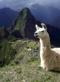
That the Incas could offer serious resistance to the Spaniards is beyond doubt. After the murder of the captive Atahualpa, for whom the Indians paid a monstrous ransom - almost 6 tons of gold, the conquistadors began to plunder the country, mercilessly melting the works of Inca jewelry into ingots. But the brother of Atahualpa Manco, appointed by them as the new emperor, instead of collecting gold for the invaders, fled and led the fight against the Spaniards. The last emperor, Tupac Amaru, was only able to be executed by Viceroy Francisco de Toledo of Peru in 1572, and even after that, the leaders of new uprisings were named after him.
Not much has survived from the Inca civilization to this day - after the death of hundreds of thousands of Indians, both at the hands of the Spaniards and from work in the mines, hunger, European epidemics, there was no one to maintain irrigation systems, high mountain roads, beautiful buildings. The Spaniards destroyed a lot to get building material.
A country whose inhabitants were accustomed to supply from public warehouses, in which there were no beggars and vagabonds, for many years after the arrival of the conquistadors became a zone of human disaster.
Nature
The Andes pass through all climatic zones, so the flora and fauna of these mountain ranges is very diverse.
Different theories determine the age of the Andean mountain system from 18 million years to several hundred million years. But, more importantly for people living in the Andes, the process of formation of these mountains is still ongoing.
Earthquakes, volcanic eruptions, glaciers in the Andes do not stop. In 1835, Charles Darwin observed the eruption of the Osorno volcano from the island of Chiloe. The earthquake described by Darwin destroyed the cities of Concepción and Talcahuano and claimed numerous victims. Such events in the Andes are not uncommon.
So, in 1970, a glacier in Peru literally in seconds buried the city of Yungay under itself with almost all the inhabitants, about 20,000 people died. In Chile in 2010, an earthquake claimed several hundred lives, left millions homeless, and caused enormous property damage. In general, serious disasters occur in the Andes with a frightening cycle - once every 10-15 years.
The most severe climate is noted on the central plateaus of the Andes, where precipitation, if any, occurs even in summer in the form of snow. It is believed that these highlands are the most barren and driest in the world, which is quite due to the combination of rarefied dry air, fierce winds and dazzling sun.
The Andes perform the function of an interoceanic watershed: the rivers belonging to the Atlantic Ocean basin flow east of the Andes, and many of them originate in the mountains; the Amazon itself, the largest river in the world, originates in the Andes. The rivers belonging to the Pacific Ocean are generally short and flow west of the Andes.
Also, the Andes, which are the longest in the world, are also a climatic barrier that isolates the Pacific coast of South America from the influence of the Atlantic Ocean, and most of the continent from the influence of the Pacific Ocean. As a result of the great length of the Andes, their landscape parts differ significantly; according to various natural features, the Northern Andes (up to 5º S), Central Andes (5-28 "S) and Southern Andes (28-41º 30º S.) are distinguished. Another feature of this mountain system is a clearly defined altitudinal zonality, according to which three belts are distinguished - tierra caliente - the lower high-altitude forest belt, tierra fria - the upper forest belt and tierra elada - a belt with a harsh climate.
Depending on the distance from the equator and the height above sea level, both equatorial, tropical and subtropical forests with their abundance of vegetation (palms, bananas, ficuses, cocoa trees, bamboos, evergreen trees and shrubs) and temperate forests grow in the Andes. Subarctic forests and tundra vegetation are characteristic of high altitudes and southern latitudes. It is believed that many of the most important agricultural crops, such as tomatoes, potatoes, tobacco, come from the Andes.
There are many unique species in the animal world of the Andes. So, Andean camels, llamas, alpacas, vigoni and guanacos are not found anywhere else in the world. The Andes are home to over 900 amphibian species, about 600 mammal species, and over 1,700 bird species. Many of them are endemic.

general information
Andes, Andean Cordillera- the longest mountain system in the world, the southern part of the Cordillera.Location: bordering the continent of South America from the north and west
States in which the Andes are located: Venezuela, Colombia, Ecuador, Peru, Bolivia, Chile, Argentina
The peoples inhabiting the Andes: Indians, Europeans, Mestizos, African Americans, Mulattos, Asians
Languages: mainly Spanish, as well as Quechua, Aymara, Guaraní and other Indian tribal languages
Religion: Primarily Catholic
Main seaports: Guayaquil (Ecuador), Valparaiso (Chile).
The most important airports: Simon Bolivar International Airport (Caracas, Venezuela); Eldorado International Airport (Santa Fe de Bogotá, Colombia), Mariscal Sucre International Airport (Quito, Ecuador), Jorge Chavez International Airport (Lima, Peru), El Alto International Airport (La Paz, Bolivia), Santiago International Airport (Chile).
The most important rivers are: Orinoco, Marañon, Ucayali, Medeira, Pilcomayo, Bermejo, Parana, Rio Salado, Colorado, Rio Negro.
Major lakes: Titicaca, Poopo.
Economy
The leading industry is mining: deposits of tungsten, silver, tin, oil are being developed (Peru, Bolivia, Venezuela, Chile); copper (Chile), gold and emeralds (Colombia), iron (Bolivia).
Agriculture: bananas (Ecuador, Colombia), potatoes, coffee (Colombia, Venezuela, Peru, Ecuador), corn, tobacco, wheat, sugar cane, olives, grapes; sheep breeding, fishing on large lakes.
Climate and weather
Due to the great length of the Andes, there is a huge variety of climate here, this mountain system stretches over six climatic zones (equatorial, northern and southern subequatorial, southern tropical, subtropical and temperate).Most of the precipitation (up to 820 mm per year) falls from May to November.
In highland Quito, the temperature is kept within +13ºС... +15ºС, but there are big differences between day and night.
Precipitation (up to 1200 mm per year) - from September to May.
In La Paz, the average monthly temperature in November is about +1ºС, in July - about +7ºС.
In Chile, the average temperature in the north of the country is from +12ºС to +22ºС, in the south - from +3ºС to +16ºС.
Attractions
■ Lake Titicaca;■ Lauca National Park;
■ Chiloe National Park;
■ Cape Horn National Park;
■ Santa Fe de Bogotá: Catholic churches of the 16th-18th centuries, National Museum of Colombia;
■ Quito: Cathedral, Museum of Musical Instruments, Museum of Del Banco Central;
■ Cusco: Cusco Cathedral, La Campagna Church, Haitun-Rumiyok Street (remains of Inca buildings);
■ Lima: the archaeological sites of Huaca Hualyamarca and Huaca Pucllana, the archbishop's palace, the church and monastery of San Francisco;
■ Archaeological complexes: Machu Picchu, Pachacamac, the ruins of the city of Caral, Tambomachay, Pukapukara, Kenko, Pisak, Ollantaytambo, Moray, the ruins of Pikiljakta.
Curious facts
■ The capital of Bolivia, La Paz, is the highest mountain capital in the world. It is located at an altitude of 3600 m above sea level.■ 200 km north of the city of Lima (Peru) are the ruins of the city of Caral - temples, amphitheatres, houses and pyramids. It is believed that Caral belonged to the oldest civilization of America and was built approximately 4000-4500 years ago. Archaeological excavations have shown that the city traded with vast areas of the South American continent. It is especially interesting that archaeologists have not found any evidence of military conflicts for about a thousand years in the history of Karala.
■ One of the most mysterious monuments of history in the world - the monumental archaeological complex of Sacsayhuaman, located northwest of Cusco, at an altitude of about 3700 meters above sea level. The fortress of the same name of this complex is attributed to the Inca civilization. However, it has not yet been possible to establish how the stones of these walls, weighing up to 200 tons and fitted to each other with jeweler's precision, were processed. Also, the ancient system of underground passages has not yet been fully explored.
■ The archaeological complex of Morai, located 74 kilometers from Cusco at an altitude of 3500 meters, is still admired not only by archaeologists. Here, huge terraces, descending, form a kind of amphitheater. Studies have shown that this building was used by the Incas as an agricultural laboratory, since the different heights of the terraces made it possible to observe plants in different climatic conditions and experiment with them. It used different soils and a complex irrigation system, in total, the Incas grew 250 plant species.
THREE BURIED SECRETS
"Miracles and Adventures" 1996/ 12
"Punched tape of giants", a stone freak show and a wall of half a thousand kilometers - these structures in the South American Andes with their grandeur are able to compete with the famous Nazca figures! And yet official archeology ignores them...
"PERFOLENTAGIGANTOV"ON THE WESTERN SLOPE OF THE ANDES
During the work of the recent World Congress of Paleoastronautics, the famous ufologist Erich von Daniken was approached by an American who introduced himself as a guest of the congress and handed him two clippings from the National Geographic magazine from an issue of the 30s. The photographs, taken with a wide-angle lens, showed a fragment of the landscape - hilly, dissected by hollows - channels of mountain streams, wild, prehistoric. Reminiscent of the foothills of the Andes - a mountain range on the western coast of South America.
The American asked what, in Daniken's opinion, the trail running obliquely down the slope meant. It was like an artificial cut that stood out against the background of the rounded hills and continued through depressions and uplands without interruption. Dani-ken just shrugged.
The interlocutor prepared another surprise: the same picture, only significantly enlarged. Now the trail had broken up into hundreds of regularly spaced depressions, most like an impression on dough from a board studded with crooked nails.
Having estimated the usual width of a nearby mountain stream, Dani-ken determined the dimensions of the mysterious strip at 15 meters, no less. Intrigued, he asked the American, "What is this?" "Here the gods drove in a chariot," he chuckled. "Look, it was a fantastic vehicle that could move on slopes."
The American could not explain where this place is located. Having already returned home and sorted through many books about Peru, Deniken did not find any mention of the "giant's punched tape", as he began to call IT to himself. What is it? Game of nature? But the correctness of the location of the recesses denied this assumption. Protective building? Rows of ancient graves? Remains of former plantations? Or traces of aliens?
He sent letters to his colleagues in Peru, enclosing copies of photographs. The answers were disappointing - no one could say anything. And, finally, it turned out that one of the Peruvian archaeologists saw this perforated strip - it is located in the spurs of the Andes in northern Peru, not far from the city of Trujillo, the center of ancient Inca culture.
A few years later, the indefatigable Swiss explorer reached Peru and met with Dr. Cabrera, the discoverer of the mysterious "black stones of Ica". After examining the pictures, he doubted that the "punched tape" existed, but nevertheless agreed to go to Montesiero's hacienda, located not far from the desired place. They began to interview local residents, but to no avail. However, after some time, one old peasant said: "There is something there" ... And uncertainly showed the scientists the direction. After a tedious ascent to a hilly ridge under the scorching sun, they suddenly saw on the opposite slope of the valley, as it were, a huge black snake. Through a telephoto lens, a "ribbon" was visible, walking continuously through hills and lowlands.
Daniken let Cabrera have a look through the telephoto while he climbed higher, where he had a better view. And then he stumbled into the first hole in the "tape", which turned out to be next to them. It was about a meter deep and a meter in diameter, round, with sheer walls. Nearby was the second, third, fourth - a real punched tape with rows of holes, going into the distance and getting lost behind the mountain.
All holes were empty. Perhaps when they were made, the soil was softer, but now, with climate change, it has become like stone. And again a comparison arose: as if a giant printing plate with meter-thick "nails" had made its imprint. At the edges of the holes there were, as it were, small rollers. The width of the tape was 24 meters.
It could be assumed that once here the Indians, following the order, buried themselves simultaneously in the ground, one next to the other. The first thing that came to mind was the defensive line! Then there must have been a huge army, whose positions were located with open flanks in the valleys and on the hills. But this would be contrary to any reasonable strategy: burrowing into the ground, the warriors could not inflict damage on the attackers, but would only sit back, squeezed into narrow holes.
Eight chains of identical holes. Hundreds of thousands of holes stretching to the horizon. When was the "perforated tape" built?
The researchers traced the tape, climbing a rather steep mountain, then descending and disappearing on the horizon, where it was swallowed up by a haze of hot air ...
Maybe it was a burial? But then it is the only one in the world, gaping for tens of kilometers, with dug out or just dug out graves. If excavated, then there should be a number of tombstones, the remains of whitened bones, ritual utensils, at least something ... There was nothing like that.
There was an assumption that this is a signal line. On a dark night, hundreds of thousands of Indians rise from tight holes and raise pitch torches on command. A chain of lights stretching out into the distance would be impressive. But for this, rows of pits were not needed - it was enough to line up and stick torches into the ground.
Or maybe this is something similar to the figures in the Nazca desert, which lies just 180 kilometers south of here - A SIGN FOR THE GODS? Of course, the winding line did not have an astronomically verified direction, but did it lead somewhere?
Questions, questions, questions... But there are no answers. Old photographs from a geographical magazine are forgotten. "Punched tape of giants" nobody needs. It is not mentioned in any scientific work. Travel agencies ignore her. So in the distant future, some young archaeologist, not yet stagnant in routine views, will stumble upon this MYSTERY OF THE ANDES and try to unravel it...
Erich von Däniken told about all this in the book "Journey to Kiribati", published in Germany in 1981. We haven't translated it yet.
More recently, a group of Peruvian scientists, who at their own peril and risk organized an expedition to the western slopes of the Andes, discovered there a continuation of the "giants' perforated tape". It began on the steep slopes of the mountains, stretched for almost 20 kilometers in a winding strip and was lost in the wet thickets of an impenetrable tropical forest. The National Archaeological Society checked the find and was forced to confirm it.
Do you think this is the only example of such silence?
STONE PANOPTICON ON THE MARCAHUASI PLATEAU
“The most important discovery of Dr. Daniel Ruso,” the newspapers told in 1952, “is the discovery of megalithic sculptures on a mountain plateau just 80 kilometers from Lima, the capital of Peru. It was made at an altitude of 4000 meters, where the climate is very harsh, the air is rarefied, the ground is rocky and lifeless.
During one of the ascents, being in the rock amphitheater, Ruso unexpectedly saw that he was surrounded by giant figures of people and animals carved from stone. There were well-recognized lions, bulls, elephants, camels that had never lived in America. Some rocks were bas-reliefs of human faces, moreover, Negro, Caucasian and Egyptian types. Among the animals was an image of an amphichelid, an extinct ancestor of the sea turtle, known only from fossilized bones.
The sculptures of horses made Rouso seriously think about whether unknown sculptors were contemporaries of the ancient American horse, which died out 9 thousand years ago. This made it possible to roughly determine the earliest date for the creation of ancient sculptures. Analyzing light diorite porphyrite, from which huge sculptures are carved, geologists made a sensational conclusion: at least 10 thousand years are required for the formation of the existing sulfuric weathering crust.
The mysterious creators of these gigantic monuments were familiar with the laws of perspective and optics. Some of the sculptures are better seen at noon, others at different hours and under different lighting conditions.
The discovery of a 10,000-year-old "museum" with images of animals that never lived in South America or became extinct tens of thousands of years ago, as well as portraits of white people and blacks that appeared in America in the last five hundred years, became a challenge to orthodox science .
Dr Russo photographed the megalithic sculptures, then made a film. He gave lectures at the Paris Sorbonne and in the USA. They were received with great interest. Official scientific circles, having familiarized themselves with photographs of the sculptures, did not deny the very fact of the discovery, but tried hard to explain everything by the "play of nature", "the result of weathering", "lighting features" and similar absurdities. They did not want to take into account the data of geologists at all.
They were particularly indignant at Rouso's hypothesis that in ancient times South America, in addition to Mongoloid Indians, also included representatives of other races.
The usual hushing up in such cases began - there are reports in newspapers, articles in magazines, but serious research on the spot has not been carried out. There is simply not a word about the discovery in scientific writings, as well as in university courses in history and archeology.
After 30 years in Peru, no one remembered the discovery - during the international geographical conference in Lima, local scientists made big eyes when colleagues from other countries asked about the results of further research. It turned out that the next generation of geographers, historians, ethnographers simply did not know about the discovery made by Daniel Ruso!
This is how orthodox scientists dealt with the epoch-making discovery, which did not fit within the FRAMEWORK OF THE OFFICIAL HISTORY OF TRADITIONAL ARCHEOLOGY! The mystery remains unsolved...
WALL, WALL!
It all started in the mid-thirties. Archaeologists Johnson and Shippey flew in a light plane to the area of the abandoned ruins of the city of Chan Chan, which became a serious archaeological sensation in those days.
After aerial photography, the scientists flew back. Mount Guascaran remained to the left, and the capricious mountain river Santa curled below. Shippi looked down and suddenly cried out: crossing the valley, the hills, the mountain ranges, a dark strip stretched like a frozen one. The "snake" was continuous, as if not paying attention to the complexity of the relief, obviously of artificial origin. The cast shadow made it clear that this was an artificial structure, a powerful fortress wall stretching for many miles from horizon to horizon.
Fortunately, several shots were not used, and the film, developed after returning to the base camp, made it possible to visually appreciate the importance of the discovery.
In the following days, several more sorties were made, which made it possible to photograph more than twenty miles of the "Great Wall", as its discoverers called it. Several key structures, conditionally called "forts", were discovered. In total, fourteen of them were found in the photographs and by visual fixation.
The main purpose of the expedition was to survey Chana-Chan. Fixed assets were exhausted, and an unplanned sensation required significant costs. Scientists did not manage to study the find in the same season, and then the plans of the Archaeological Commission were linked to urgent work in another area ...
Shippey and Johnson left Peru. The message about the find was soon forgotten, and the photographs and negatives ended up in the archive. For many years, the wall did not come across anyone's eyes. Local residents did not climb into these lifeless wild places - there were no conditions for agricultural work, there was no hunting. Only thirty years later, materials about the discovery were again brought to light.
The expedition was led by a well-known scientist, a specialist in paleoethnography, J. Savoy. When archaeologists got to the search area, a sensation awaited them - instead of one "Great Wall" discovered by Shippey and Johnson, they found SIX walls there! Together with intermediate fortified points ("forts" - according to the former name), there was a defensive system, striking in its size. The height of the walls, stretching for a total of 500 kilometers, reaches ten meters. These complex fortifications were erected high in the mountains, where it is difficult for a climber to reach. Some areas could not be explored, as landslides demolished mountain trails.
Who built these majestic walls? So far, no response has been received. The exact timing of the construction of the walls is also not determined, but indirect evidence suggests that it was nine centuries ago. It is possible that these gigantic fortifications were built by an even more ancient people, traces of whose activities are found on the territory of Peru, Ecuador and Colombia. But no one knows anything about him, and there are still no attempts to somehow clarify this issue ...
The mysteries of the ancient Andean cultures - particles of human culture - remain unanswered. And the question is natural: who is really lazy and incurious?
