Siberia is a vast historical and geographical region in the northeast of Eurasia. Today it is almost entirely located within the Russian Federation. The population of Siberia is represented by Russians, as well as numerous indigenous peoples (Yakuts, Buryats, Tuvans, Nenets and others). In total, at least 36 million people live in the region.
This article will focus on the general features of the population of Siberia, the largest cities and the history of the development of this territory.
Siberia: general characteristics of the region
Most often, the southern border of Siberia coincides with the state border of the Russian Federation. In the west it is bounded by the ranges of the Ural Mountains, in the east by the Pacific, and in the north by the Arctic Ocean. However, in the historical context, Siberia also covers the northeastern territories of modern Kazakhstan.
The population of Siberia (as of 2017) is 36 million people. Geographically, the region is divided into Western and Eastern Siberia. The line of demarcation between them is the Yenisei River. The main cities of Siberia are Barnaul, Tomsk, Norilsk, Novosibirsk, Krasnoyarsk, Ulan-Ude, Irkutsk, Omsk, Tyumen.
As for the name of this region, its origin is not precisely established. There are several versions. According to one of them, the toponym is closely connected with the Mongolian word "shibir" - it is a swampy area overgrown with birch groves. It is assumed that this is what the Mongols called this area in the Middle Ages. But according to Professor Zoya Boyarshinova, the term came from the self-name of the ethnic group "Sabir", whose language is considered the ancestor of the entire Ugric language group.

The population of Siberia: density and total number
According to the 2002 census, 39.13 million people lived within the region. However, the current population of Siberia is only 36 million inhabitants. Thus, it is a sparsely populated area, but its ethnic diversity is truly enormous. More than 30 peoples and nationalities live here.
The average population density in Siberia is 6 people per 1 square kilometer. But it is very different in different parts of the region. Thus, the highest population density rates are in the Kemerovo region (about 33 people per sq. km.), and the lowest - in the Krasnoyarsk Territory and the Republic of Tyva (1.2 and 1.8 people per sq. km., respectively). The most densely populated valleys of large rivers (Ob, Irtysh, Tobol and Ishim), as well as the foothills of the Altai.
The level of urbanization here is quite high. So, at least 72% of the inhabitants of the region live in the cities of Siberia today.
Demographic problems of Siberia
The population of Siberia is rapidly declining. Moreover, the mortality and birth rates here, in general, are almost identical to the national ones. And in Tula, for example, the birth rate is completely astronomical for Russia.
The main reason for the demographic crisis in Siberia is the migration outflow of the population (primarily young people). And the leader in these processes is the Far Eastern Federal District. From 1989 to 2010, it "lost" almost 20% of its population. According to surveys, about 40% of Siberian residents dream of moving to other regions for permanent residence. And these are very sad figures. Thus, Siberia, conquered and mastered with such great difficulty, is emptying every year.

Today, the balance of migration in the region is 2.1%. And this figure will only grow in the coming years. Siberia (in particular, its western part) is already very acutely experiencing a shortage of labor resources.
The indigenous population of Siberia: a list of peoples
Siberia in ethnic terms is an extremely diverse territory. Representatives of 36 indigenous peoples and ethnic groups live here. Although Russians prevail in Siberia, of course (about 90%).
The top ten indigenous peoples in the region are:
- Yakuts (478,000 people).
- Buryats (461,000).
- Tuvans (264,000).
- Khakass (73,000).
- Altaians (71,000).
- Nenets (45,000).
- Evenks (38,000).
- Khanty (31,000).
- Evens (22,000).
- Mansi (12,000).
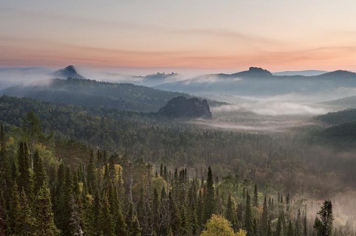
The peoples of the Turkic group (Khakas, Tuvans, Shors) live mainly in the upper reaches of the Yenisei River. Altaians - concentrated within the Altai Republic. Mostly Buryats live in Transbaikalia and Cisbaikalia (pictured below), and Evenks live in the taiga of the Krasnoyarsk Territory.

The Taimyr Peninsula is inhabited by Nenets (in the next photo), Dolgans and Nganasans. But in the lower reaches of the Yenisei, the Kets live compactly - a small people who use a language that is not included in any of the known language groups. Tatars and Kazakhs also live in the southern part of Siberia within the steppe and forest-steppe zones.

The Russian population of Siberia, as a rule, considers itself to be Orthodox. Kazakhs and Tatars are Muslims by their religion. Many of the region's indigenous peoples adhere to traditional pagan beliefs.
Natural resources and economics
"Pantry of Russia" - this is how Siberia is often called, meaning the mineral resources of the region, grandiose in scale and diversity. So, there are colossal reserves of oil and gas, copper, lead, platinum, nickel, gold and silver, diamonds, coal and other minerals. About 60% of the all-Russian peat deposits lie in the bowels of Siberia.
Of course, the economy of Siberia is fully focused on the extraction and processing of natural resources in the region. Moreover, not only mineral and fuel and energy, but also forest. In addition, non-ferrous metallurgy and the pulp industry are well developed in the region.

At the same time, the rapid development of the mining and energy industries could not but affect the ecology of Siberia. So, it is here that the most polluted cities of Russia are located - Norilsk, Krasnoyarsk and Novokuznetsk.
History of the development of the region
After the collapse of the Golden Horde, the lands east of the Urals, in fact, turned out to be no man's land. Only the Siberian Tatars managed to organize their own state here - the Siberian Khanate. True, it did not last long.
Ivan the Terrible took up the colonization of Siberian lands in earnest, and even then only towards the end of his tsarist reign. Prior to this, the Russians were practically not interested in the lands located beyond the Urals. At the end of the 16th century, the Cossacks, under the leadership of Yermak, founded several fortress cities in Siberia. Among them are Tobolsk, Tyumen and Surgut.
Initially, Siberia was mastered by exiles and convicts. Later, already in the 19th century, landless peasants began to come here in search of free hectares. Serious exploration of Siberia began only at the end of the 19th century. In many ways, this was facilitated by the laying of the railway line. During the Second World War, large factories and enterprises of the Soviet Union were evacuated to Siberia, and this had a positive impact on the development of the region's economy in the future.
Main cities
There are nine cities in the region, the population of which exceeds the 500,000 mark. This is:
- Novosibirsk.
- Omsk.
- Krasnoyarsk.
- Tyumen.
- Barnaul.
- Irkutsk.
- Tomsk.
- Kemerovo.
- Novokuznetsk.
The first three cities on this list are "millionaires" in terms of population.
Novosibirsk is the unspoken capital of Siberia, the third most populated city in Russia. It is located on both banks of the Ob, one of the largest rivers in Eurasia. Novosibirsk is an important industrial, commercial and cultural center of the country. The leading industries of the city are energy, metallurgy and mechanical engineering. The economy of Novosibirsk is based on about 200 large and medium enterprises.

Krasnoyarsk is the oldest of the major cities in Siberia. It was founded back in 1628. It is the most important economic, cultural and educational center of Russia. Krasnoyarsk is located on the banks of the Yenisei, on the conditional border of Western and Eastern Siberia. The city has a developed space industry, mechanical engineering, chemical industry and pharmaceuticals.
Tyumen is one of the first Russian cities in Siberia. Today it is the most important oil refining center in the country. Oil and gas production contributed to the rapid development of various scientific organizations in the city. Today, about 10% of the able-bodied population of Tyumen works in research institutes and universities.
Finally
Siberia is the largest historical and geographical region of Russia with a population of 36 million people. It is unusually rich in various natural resources, but suffers from a number of social and demographic problems. There are only three million-plus cities within the region. These are Novosibirsk, Omsk and Krasnoyarsk.
Everyone knows that Siberia is part of the territory of the Russian Federation (and most of it). And they heard about her untold riches, and about the beauties, and about the significance for the country - most likely, too. But where Siberia is exactly, many find it difficult to answer. Even Russians will not always be able to show it on the map, not to mention foreigners. And the more difficult will be the question of where is Western Siberia, and where is its eastern part.
Geographic location of Siberia
Siberia is a region that combines many administrative-territorial units of Russia - regions, republics, autonomous regions and territories. Its total area is about 13 million square kilometers, which is 77 percent of the entire territory of the country. A small part of Siberia belongs to Kazakhstan.
To understand where Siberia is located, you need to take a map, find it on it and “walk” from them east to the Pacific Ocean (the path will be approximately 7 thousand km). And then find the Arctic Ocean and descend "from its shores" to the north of Kazakhstan and to the borders with Mongolia and China (3.5 thousand km).
It is within these limits that Siberia is located, which occupies the northeastern part of the Eurasian continent. In the west it ends at the foot of the Ural Mountains, in the east it is limited to the Oceanic Ranges. The north of Mother Siberia "flows" into the Arctic Ocean, and the south rests on the rivers: Lena, Yenisei and Ob.
And all this space, rich in natural resources and untraveled paths, is usually divided into Western Siberia and Eastern Siberia.
Where is Geographical location
The western part of Siberia extends from the Ural Mountains to the Yenisei River for 1500-1900 kilometers. Its length is slightly more - 2500 km. And the total area is almost 2.5 million square kilometers (15% of the territory of the Russian Federation).
Most of it lies on the West Siberian Plain. It covers such regions of the Russian Federation as Kurgan, Tyumen, Omsk, Tomsk, Kemerovo, Novosibirsk, Sverdlovsk and Chelyabinsk (partially). It also includes the Yamalo-Nenets Autonomous Okrug, the Altai Territory, the Republic of Altai, Khakassia and the western part of the Krasnoyarsk Territory.
Where is Eastern Siberia located? Features of the territorial location
Most of Siberia is called Eastern. Its territory covers about seven million square kilometers. It stretches to the east from the Yenisei River to the mountain formations separating the Arctic and Pacific oceans.
The northernmost point of Eastern Siberia is considered and the southern limit is the border with China and Mongolia.

This part is located mainly on and covers the Taimyr Territory, Yakutia, Tungus, Irkutsk Region, Buryatia, and also Transbaikalia.
Thus, the answer to the question of where Siberia is located has been received, and finding it on the map will not be a problem. It remains to supplement theoretical knowledge with practical ones and find out what Siberia is from the personal experience of the traveler.
Russian Cossacks began to penetrate beyond the Urals in the 15th century. And already in the 16th century, the Tatar Khanate, located at the confluence of the Irtysh and Tobol rivers, paid tribute to Ivan the Terrible. And the tsar in 1570, in a letter to the English queen, called himself “The Sovereign of Pskov, and the Grand Duke of Smolensk, Tver, Chernigov ... and all the Siberian lands”, that is, Siberia was already known not only in Russia, but also abroad .
Siberia in the Middle Ages
In the XV century, according to the drawings of Siberian Tatarstan by the Italian Cardinal Stefan Borgia, Siberia was located on the eastern bank of the Volga. On the map of the Venetian monk Fra Mauro in 1459, the "Province of Siberia" occupied a place in the upper reaches of the Kama and Vyatka. Of course, the Italian maps looked like fantastic illustrations, they did not contain any details, but they can be used to judge the idea of Europeans about a large, distant and wild country.
On Russian maps of the 15th century, Siberia is depicted on the lands of the Tatar Khanate, which includes northern Kazakhstan and the lands of modern Sverdlovsk, Kurgan, Chelyabinsk, Tyumen and Omsk regions.
Russian "drawings"
The first Russian map "Drawing of the Siberian land" was made in 1667 by the governor of Tobolsk, Pyotr Godunov. The north on the "Drawing" was at the bottom, the south was at the top, the rivers were depicted schematically, and the distances were measured by "horse riding days." The Ob basin was shown in detail, and the Lena flowed into the "sea" in the east. Five years later, an improved version appeared - "Drawing of all Siberia to the Chinese kingdom", that is, the territory of Siberia now ran to China.
A more detailed map was compiled by the cartographer Semyon Remizov in 1697; on it, Siberia began beyond the Volga and ended in the east with Kamchatka, in the north it was washed by the Mangazeya and Arctic seas, and in the south it bordered on the Aral Sea, the “Kalmyk nomads” and the Chinese kingdom. The east coast and the north were drawn in detail on the map - the mouths of the Lena and Kolyma rivers, the lands of the Tungus, the possessions of the "shamans", the Amur and Korea were indicated. This means that at the end of the 17th century Siberia stretched from the Volga to the Pacific Ocean and from the Arctic Ocean to the Aral Sea.
At first Siberia grew
Over time, the idea changed: in the west, the border of Siberia moved to the Urals, and at the end of the 18th century, when the Perm province was created, geographers limited Siberia to the eastern borders of the Perm and Tobolsk provinces.
In 1822, at the initiative of the governor Mikhail Speransky, Siberia was divided into two governorates - West Siberian and East Siberian, and this forever divided Siberia into two parts. Western Siberia of the 19th century included Tobolsk and Tomsk provinces, Omsk region and part of Kazakhstan, while Eastern Siberia extended to the ocean and consisted of the territories of the Yenisei basin, Angara, Transbaikalia, Buryatia, Chukotka, Kamchatka and Yakutia.
And then it decreased
After the Amur and Ussuri regions were annexed, a new region appeared in the minds of people - the Far East, and Siberia began to decrease: at the turn of the 19th and 20th centuries, Siberian lands began to be attributed to the Far East. According to the works of the ethnographer Nikolai Yadrintsev, in the 19th century Siberia included the lands of modern Kurgan and Tyumen regions with the Khanty-Mansiysk and Yamalo-Nenets Autonomous Okrug in the west and the lands of Transbaikalia, the Amur region and Yakutia in the east. Its area occupied more than 12,000,000 square meters. km or 73% of the country's territory.
In the XX century, in the era of the Soviet Union, Siberia included administrative units from Omsk to Baikal, and in the south it was limited in 1936 by the Kazakh ASSR.
The geographers of the late USSR considered the Sverdlovsk and Kurgan regions to be the Urals, and the rest of the territories up to Baikal itself were considered Siberia, which was still divided into Western and Eastern, while Yakutia was singled out as a separate entity. Buryatia, the Chita region (Transbaikalia) and the republics also became separate subjects.
Modern geography
Ten years after the collapse of the USSR, the government divided the country into administrative districts, which again influenced the idea of \u200b\u200bRussians about Siberia: now the Tyumen region is also referred to the Urals - it is called the Ural region, and Siberia is limited to the Siberian Federal District, which includes 12 regions of Russia: from Omsk region to Transbaikalia. Now the area of Siberia is 5,144,953 sq. km. 19,326,196 people or 13.16% of the country's population live there. However, despite the fact that there are 132 large cities in Siberia, and three of them are millionaires (Omsk, Novosibirsk and Krasnoyarsk), the population density is four people per square kilometer. km.
Russian science has not yet decided on a single designation of Siberia. In the school curriculum, for example, this is something between traditional ideas and modern administrative division.
After 3 months of aimless wandering through the dense Siberian forests, I went out to the clearing, and my eyes opened up to the wonderful Siberian city of Novy Sibirsk. I saw a lot of things hitherto unknown to me in this New Siberian. First, eternal winter, well. Eternal winter and permafrost. Secondly, scattered in the coniferous thicket and surrounded by a high fence of ship pine, there are 30-40 squat, roughly hewn wooden log cabins, in which 6-8 dozen bearded men live in each. Thirdly, along a single clearing cut in the taiga, which is paved with ship pine, a lonely, icy and snow-covered tram without windows and brakes walks. Bearded, two-meter-tall men in bear sheepskin coats, felt boots and fox hats with earflaps, with wide skis cut from ship pine, balalaikas and double-barreled shotguns are sitting in the tram. The peasants smoke shag, mixed with shavings and resin of the ship's pine, leisurely talk in their gibberish Siberian language and pat the ears of their huge fanged dogs, from the formidable appearance of which the soul sinks into the heels. A double-barreled shotgun, skis, a balika and a hat with earflaps are indispensable accessories for every inhabitant of Siberia. Therefore, without this props you will disappear in the taiga. There are no sidewalks and gas lighting in the city - either because of uselessness, or because all the produced gas and asphalt is exported to China and India. Around the city there is an impassable taiga and clouds of midges, from which there is no salvation either day or night ...
In particularly severe winters, when frosts set in -260, or even -273 degrees Celsius (however, for Siberia, the absolute zero temperature is not the coldest temperature, it can be frosty and stronger), bears and wolves come from the taiga to the city in order to warm themselves in the huts and wander along the boardwalk in search of food. Sometimes the bears manage to lure old felt boots and balalaikas from the harsh Siberian men. But most often a meeting with a person ends sadly for them. The men, without getting out of the tram, load double-barreled shotguns and bang on the beast. No one takes the skin and meat, since every Siberian has them in abundance, and those who might need them do not go to Siberia. Because of this, the city is always full of the corpses of dead animals, the sky above the city is black from carrion-eating crows, and the city itself is shrouded in smoke and a heavy, vigorous smell of gunpowder and peasant footcloths hangs in the air. Excited by the shooting, the men immediately, without getting out of the tram, jam pure 100% spruce alcohol, strum on balalaikas, argue hotly about politics and swear obscenely in their gibberish Siberian language.
Women do not live in Siberia. But I was warmly welcomed, warmed, treated kindly, fed with bear meat and drunk with spruce alcohol by harsh Siberian peasants, for which I bow to them and many years ...
