I have always been in awe of the sight of mountain peaks propping up the sky, bathed in sunlight. Powerful, monumental, unshakable Atlanteans, breathing calmness. And if I am faced with a choice between the sea, the forest, and huge stone masses, I will without hesitation prefer the latter. Only mountains can be better than mountains!
And there are few places on the planet where I have experienced such inspiration as near the majestic Andes. As part of the Cordillera mountain range that bisects the planet from the northernmost extremities of Canada almost to Antarctica itself, the Andes proudly bear the responsibility of keeping the waters of the Pacific and Atlantic oceans in the southern hemisphere from mixing. The highest, longest, youngest mountains in the world. Rising to a height of almost 7,000 meters, strewn with dormant and awake volcanoes, this huge prehistoric creature stretches for 9,000 kilometers and plunges its southern edge into turbulent waters, forming a complex pattern of straits and glaciers, where ships have died for many centuries. The Andes keep a lot of secrets, mysteries and dangers: the gold of the Incas is hidden somewhere, planes died somewhere.
This is where I come back every time an airline like Iberia, Lufthansa or Turkish Airways announces a sale.
Northern Andes
In the north, the Andes rise above the tropical rainforests of Venezuela, Colombia and Ecuador, their character is difficult: the height of 4500-6000 meters and changeable weather require special skills from the tourist. But you can choose a simpler option: rent a car and go around the foothills of volcanoes and lakes, or take a ride on the longest cable car in the world (almost 2 kilometers) Teleferico de Merida in Venezuela.
Central Andes
On the territory of Peru and Bolivia, the Andes keep in their depths vast and fertile plateaus on which the Incas once built cities. But for me, the main treasures of these places are high-altitude lakes, full-flowing like Titicaca and turned into salt marshes like. You can spend some amazing days exploring the customs of the inhabitants of the island of Taquile on Titicaca, where men knit from colored wool. Or spending the night on the reed-woven islands of Uros under huge and bright stars at an altitude of 3800 meters. Or rushing with a breeze through a huge pit of salt. Or coming up with the most incredible compositions for photography in a place where there is no perspective. And, of course, enjoying the most memorable sunsets in life.
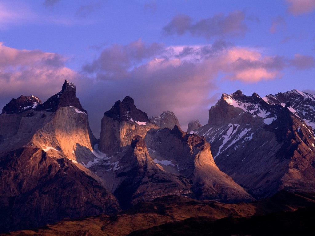
Southern Andes, Carretera Austral
A long and narrow strip of land called Chile and the endless Argentinean pampas stretch along the Andean ridges, the tops of which cling to clouds. Moreover, they cling in the literal sense: rain clouds driven by Pacific winds cannot overcome the mountain barrier and shed precious moisture on the southern Chilean side (northern Chile is not so lucky with the world's driest Atacama desert). The famous road, built in the mid-1970s under Pinochet, winds here - Carretera Austral, or "southern road". This is one of the most picturesque and interesting routes I have ever traveled, it gives me the opportunity to fully enjoy the beauty of mountain peaks, turbulent rivers, azure lakes and proud pines for 1240 kilometers.
The best time to travel is during the summer months (December to February) as the ferries are closed at other times of the year and you won't be able to enjoy the full experience of the trip. Therefore, feel free to plan a big vacation for the January holidays and then, in addition to the famous South Road, you will be able to see the huge Perito Moreno glacier, breathe in the famous Patagonian winds and find out why Tierra del Fuego is called that. By the way, the Northern and Central Andes are friendly to travelers all year round.
Where to start
The starting point of Carretera Austral is the Chilean city of Puerto Montt. This is a nice little village with a European spirit, from where tourists, after admiring the old mahogany cathedral, go to the Lake District, to the Villarrica volcano or to the island of Chiloe. Here you have to decide how you will conquer the South Road: the most daring go hitchhiking or on bicycles, while the rest rent a car.
From the island of Chiloe, you can take a ferry to the town of Chaiten and move either north or south.
Another option is to start from the south, from the village of Villa O "Higgins, which can be reached by ferry from Argentina, which runs several times a week from November to March and only takes on board pedestrians or cyclists (costs about $ 60, or 40,000 pesos) , or entrusting itself to the care of a travel company that not only organizes delivery to the ferry by bus, but also offers to see the glaciers on the lake "on the way" (the tour will cost from $130).
What to bring
- Regardless of which method of transportation you choose, you need to have a supply of provisions with you, you will meet supermarkets only in relatively large settlements, in other settlements - only village shops with a minimum set of products.
- Do not forget a set of medicines you need and essentials (from a band-aid to toothpaste and repellents). Carretera Austral is not the place where you can take only a passport and a credit card.
- Comfortable clothes and shoes are a must as there are so many amazing alluring places to explore!
- Enough cash in local currency (Chilean pesos), you will not find ATMs until Coyaic itself, and cards are not accepted anywhere.
If you choose to travel on foot or by bike
Since the distances between settlements and campsites are large, you will need:
- tent,
- sleeping bag (in the mountains even in summer the nights are cold),
- gas-burner,
- pot and utensils,
- and other camping gear.
You can rent everything you need, including a bicycle, in Puerto Monte (the choice is very scarce, and the prices are very high) or in Santiago, where a huge number of rentals with good bicycles are open. To do this, you will need to present a passport and a bank card to hold a deposit (depending on the rental period from $ 250). The rental price starts from $30 per day or $120 per week.
If you choose to travel by car
You can rent a car in Puerto Monte or, as I did, in Santiago (in this case, you will need to set aside several days to drive along the magnificent highway for almost 1000 kilometers, stopping at wineries and stopping by national parks).
- Prepare, in addition to ordinary rights, international rights (some rental agencies do not issue a car without them) and, of course, a bank card with a sufficient amount in the account to block the deposit.
- Explore the websites of rental offices to choose the most suitable option. In no case do not watch small cars, only four-wheel drive! If possible, give up the options for cars that seem to have just come out of the salon, choose a car that has undergone a baptism of fire, because small stones will inevitably fly on a gravel road.
- South of the Carretera Austral Andes are full of many magnificent landscapes, for example, you can admire the famous peak of Fitzroy and the beauty of the Torres del Paine National Park. But, since some regions of the country are occupied by impenetrable mountains, part of the journey will have to be done through the territory of Argentina. To do this, you will need special documents for the car. Be sure to contact the rental agency in advance - documents for crossing the border are prepared for several days. And be prepared for the fact that you will be charged a fee of $ 200 for registration.
- You will rarely encounter gas stations along the way, so take every opportunity to replenish your gas supplies.
So, you are saddled with a four-wheeled beast (I, for example, got a red pickup truck, on the hood of which someone played tic-tac-toe with a nail) and are ready for adventure.
By sea
At the very beginning of the journey, three ferries will be waiting for you, which will go around the impregnable, densely forested mountain slopes (see the map below). The first ferry departs from La Arena every hour and costs about $15 (10,000 pesos) per car. In half an hour you will reach the peninsula, which can only be reached by sea. The second ferry leaves from the Ornopien settlement (it has several shops and you can stop for the night), located at the southern end of the peninsula, twice a day - in the morning and in the afternoon. It is better to check the schedule in Puerto Monte. This ferry takes 5 hours and costs $54 (35,000 pesos) and this price includes the third ferry, which leaves when all passengers on the second ferry have safely covered 10 kilometers of gravel.
By land
As a result of all sea travels, during which majestic mountains, forests and waterfalls will pass by, you will find yourself in the village of Kaleto Gonzalo. From here, boldly head south, stopping in picturesque places and climbing deep into the mountains. Your speed will average 50 km/h, so you won't miss the signs for recommended hiking trails to particularly beautiful and amazing natural treasures and numerous national parks.
Carretera Austral ends at a dead end in the village of Villa O'Higgins, from where you can cross to Argentina (only those who travel on foot or by bicycle are taken on the ferry), or go back if you travel by car.
Where to go
Along the Southern Road, you will encounter several opportunities to cross the border into Argentina: at the village of Santa Lucia, next to the Lago las Torres park, the town of Coyaki and before reaching Cochrane. I would highly recommend the latter option, since you will not only be able to see almost all of Carretera Austral, but also drive past a magnificent lake, which in the Chilean part is called Lago General Carrera, and in the Argentinean part, Lago Buenos Aires.
Tourist infrastructure
You can spend the night in campsites, which are scattered along the entire Carretera Austral, or in settlements. Almost all locals rent rooms from $10 to $55 (8000-35000 pesos) per night for two and will be happy to feed you breakfast (and not always for an additional fee). Free campsites are just cleared areas. Those equipped with a toilet, hot showers and awnings will cost from $5 to $10 per night.
For example, on January 2nd, I stopped in the picturesque village of Via Cerro Castillo, where the whole large family of the owners gathered for dinner in the evening. Despite my poor knowledge of Spanish, I was invited to share a meal with everyone and enjoy a wonderful evening. The men prepared a traditional dish - they roasted a young lamb on the cross - a la cruz, and the women cut fresh vegetables and herbs. It was the most delicious lamb I have ever tasted in my life. And the glare of the fire on their open and friendly faces, songs to the accordion and majestic mountains under the shadow of the starry sky forever stuck in my memory.
Catering establishments are found only in the largest settlements: Ornopyrene, Koyaki, Cochrane. Elsewhere, the best you can expect are small grocery stores. I usually tried to have a hearty breakfast and dinner where I spent the night (if the hosts did not cook, then I asked permission to use the kitchen), and during the day I was rescued by pre-made sandwiches.
Southern Andes, Patagonia and Tierra del Fuego
On the western edge of the Patagonian steppes rise the Southern Andes. They are no longer as high as in the north, but no less beautiful for that. Along the entire foothills of the mountains there are delightful nature reserves, the main pearls of which are the giant Perito Moreno glacier, one of only two on the planet Earth that does not decrease, but grows, and the Torres del Paine park, the harsh beauty of which attracts travelers from all over the world. What marvels Patagonia has prepared and how to get to them is well written.
And further south, the red grass of Tierra del Fuego rustles under the wind, where, according to legend, the giants lived, and the Andes lower their tail, dotted with peaks, into the ocean, from which glaciers slide down like hats. Here, as the last stronghold of the mountains, Cape Horn rises from the water, landing on which is good luck. Few ships and fierce cold currents roam between this lone lighthouse outpost and Argentina.
The Andes are many-sided and unpredictable, they fascinate and fall in love, having seen them at least once, you will return again and again. After all, only the Andes can be better than mountains!
THREE BURIED SECRETS
"Miracles and Adventures" 1996/ 12
"Punched tape of giants", a stone freak show and a wall of half a thousand kilometers - these structures in the South American Andes with their grandeur are able to compete with the famous Nazca figures! And yet official archeology ignores them...
"PERFOLENTAGIGANTOV"ON THE WESTERN SLOPE OF THE ANDES
During the work of the recent World Congress of Paleoastronautics, the famous ufologist Erich von Daniken was approached by an American who introduced himself as a guest of the congress and handed him two clippings from the National Geographic magazine from an issue of the 30s. The photographs, taken with a wide-angle lens, showed a fragment of the landscape - hilly, dissected by hollows - channels of mountain streams, wild, prehistoric. Reminiscent of the foothills of the Andes - a mountain range on the western coast of South America.
The American asked what, in Daniken's opinion, the trail running obliquely down the slope meant. It was like an artificial cut that stood out against the background of the rounded hills and continued through depressions and uplands without interruption. Dani-ken just shrugged.
The interlocutor prepared another surprise: the same picture, only significantly enlarged. Now the trail had broken up into hundreds of regularly spaced depressions, most like an impression on dough from a board studded with crooked nails.
Having estimated the usual width of a nearby mountain stream, Dani-ken determined the dimensions of the mysterious strip at 15 meters, no less. Intrigued, he asked the American, "What is this?" "Here the gods drove in a chariot," he chuckled. "Look, it was a fantastic vehicle that could move on slopes."
The American could not explain where this place is located. Having already returned home and sorted through many books about Peru, Deniken did not find any mention of the "giant's punched tape", as he began to call IT to himself. What is it? Game of nature? But the correctness of the location of the recesses denied this assumption. Protective building? Rows of ancient graves? Remains of former plantations? Or traces of aliens?
He sent letters to his colleagues in Peru, enclosing copies of photographs. The answers were disappointing - no one could say anything. And, finally, it turned out that one of the Peruvian archaeologists saw this perforated strip - it is located in the spurs of the Andes in northern Peru, not far from the city of Trujillo, the center of ancient Inca culture.
A few years later, the indefatigable Swiss explorer reached Peru and met with Dr. Cabrera, the discoverer of the mysterious "black stones of Ica". After examining the pictures, he doubted that the "punched tape" existed, but nevertheless agreed to go to Montesiero's hacienda, located not far from the desired place. They began to interview local residents, but to no avail. However, after some time, one old peasant said: "There is something there" ... And uncertainly showed the scientists the direction. After a tedious ascent to a hilly ridge under the scorching sun, they suddenly saw on the opposite slope of the valley, as it were, a huge black snake. Through a telephoto lens, a "ribbon" was visible, walking continuously through hills and lowlands.
Daniken let Cabrera have a look through the telephoto while he climbed higher, where he had a better view. And then he stumbled into the first hole in the "tape", which turned out to be next to them. It was about a meter deep and a meter in diameter, round, with sheer walls. Nearby was the second, third, fourth - a real punched tape with rows of holes, going into the distance and getting lost behind the mountain.
All holes were empty. Perhaps when they were made, the soil was softer, but now, with climate change, it has become like stone. And again a comparison arose: as if a giant printing plate with meter-thick "nails" had made its imprint. At the edges of the holes there were, as it were, small rollers. The width of the tape was 24 meters.
It could be assumed that once here the Indians, following the order, buried themselves simultaneously in the ground, one next to the other. The first thing that came to mind was the defensive line! Then there must have been a huge army, whose positions were located with open flanks in the valleys and on the hills. But this would be contrary to any reasonable strategy: burrowing into the ground, the warriors could not inflict damage on the attackers, but would only sit back, squeezed into narrow holes.
Eight chains of identical holes. Hundreds of thousands of holes stretching to the horizon. When was the "perforated tape" built?
The researchers traced the tape, climbing a rather steep mountain, then descending and disappearing on the horizon, where it was swallowed up by a haze of hot air ...
Maybe it was a burial? But then it is the only one in the world, gaping for tens of kilometers, with dug out or just dug out graves. If excavated, then there should be a number of tombstones, the remains of whitened bones, ritual utensils, at least something ... There was nothing like that.
There was an assumption that this is a signal line. On a dark night, hundreds of thousands of Indians rise from tight holes and raise pitch torches on command. A chain of lights stretching out into the distance would be impressive. But for this, rows of pits were not needed - it was enough to line up and stick torches into the ground.
Or maybe this is something similar to the figures in the Nazca desert, which lies just 180 kilometers south of here - A SIGN FOR THE GODS? Of course, the winding line did not have an astronomically verified direction, but did it lead somewhere?
Questions, questions, questions... But there are no answers. Old photographs from a geographical magazine are forgotten. "Punched tape of giants" nobody needs. It is not mentioned in any scientific work. Travel agencies ignore her. So in the distant future, some young archaeologist, not yet stagnant in routine views, will stumble upon this MYSTERY OF THE ANDES and try to unravel it...
Erich von Däniken told about all this in the book "Journey to Kiribati", published in Germany in 1981. We haven't translated it yet.
More recently, a group of Peruvian scientists, who at their own peril and risk organized an expedition to the western slopes of the Andes, discovered there a continuation of the "giants' perforated tape". It began on the steep slopes of the mountains, stretched for almost 20 kilometers in a winding strip and was lost in the wet thickets of an impenetrable tropical forest. The National Archaeological Society checked the find and was forced to confirm it.
Do you think this is the only example of such silence?
STONE PANOPTICON ON THE MARCAHUASI PLATEAU
“The most important discovery of Dr. Daniel Ruso,” the newspapers told in 1952, “is the discovery of megalithic sculptures on a mountain plateau just 80 kilometers from Lima, the capital of Peru. It was made at an altitude of 4000 meters, where the climate is very harsh, the air is rarefied, the ground is rocky and lifeless.
During one of the ascents, being in the rock amphitheater, Ruso unexpectedly saw that he was surrounded by giant figures of people and animals carved from stone. There were well-recognized lions, bulls, elephants, camels that had never lived in America. Some rocks were bas-reliefs of human faces, moreover, Negro, Caucasian and Egyptian types. Among the animals was an image of an amphichelid, an extinct ancestor of the sea turtle, known only from fossilized bones.
The sculptures of horses made Rouso seriously think about whether unknown sculptors were contemporaries of the ancient American horse, which became extinct 9,000 years ago. This made it possible to roughly determine the earliest date for the creation of ancient sculptures. Analyzing light diorite porphyrite, from which huge sculptures are carved, geologists made a sensational conclusion: at least 10 thousand years are required for the formation of the existing sulfuric weathering crust.
The mysterious creators of these gigantic monuments were familiar with the laws of perspective and optics. Some of the sculptures are better seen at noon, others at different hours and under different lighting conditions.
The discovery of a 10,000-year-old "museum" with images of animals that never lived in South America or became extinct tens of thousands of years ago, as well as portraits of white people and blacks that appeared in America in the last five hundred years, became a challenge to orthodox science .
Dr Russo photographed the megalithic sculptures, then made a film. He gave lectures at the Paris Sorbonne and in the USA. They were received with great interest. Official scientific circles, having familiarized themselves with photographs of the sculptures, did not deny the very fact of the discovery, but tried hard to explain everything by the "play of nature", "the result of weathering", "lighting features" and similar absurdities. They did not want to take into account the data of geologists at all.
They were particularly indignant at Rouso's hypothesis that in ancient times South America, in addition to the Mongoloid Indians, also included representatives of other races.
The usual hushing up in such cases began - there are reports in newspapers, articles in magazines, but serious research on the spot has not been carried out. There is simply not a word about the discovery in scientific writings, as well as in university courses in history and archeology.
After 30 years in Peru, no one remembered the discovery - during the international geographical conference in Lima, local scientists made big eyes when colleagues from other countries asked about the results of further research. It turned out that the next generation of geographers, historians, ethnographers simply did not know about the discovery made by Daniel Ruso!
This is how orthodox scientists dealt with the epoch-making discovery, which did not fit within the FRAMEWORK OF THE OFFICIAL HISTORY OF TRADITIONAL ARCHEOLOGY! The mystery remains unsolved...
WALL, WALL!
It all started in the mid-thirties. Archaeologists Johnson and Shippey flew in a light plane to the area of the abandoned ruins of the city of Chan Chan, which became a serious archaeological sensation in those days.
After aerial photography, the scientists flew back. Mount Guascaran remained to the left, and the capricious mountain river Santa curled below. Shippi looked down and suddenly cried out: crossing the valley, hills, mountain ranges, a dark strip stretched like a frozen one. The "snake" was continuous, as if not paying attention to the complexity of the relief, obviously of artificial origin. The cast shadow made it clear: this is an artificial structure, a powerful fortress wall, stretching for many miles from horizon to horizon.
Fortunately, several shots were not used, and the film, developed after returning to the base camp, made it possible to visually appreciate the importance of the discovery.
In the following days, several more sorties were made, which made it possible to photograph more than twenty miles of the "Great Wall", as its discoverers called it. Several key structures, conditionally called "forts", were discovered. In total, fourteen of them were found in the photographs and by visual fixation.
The main purpose of the expedition was to survey Chana-Chan. Fixed assets were exhausted, and an unplanned sensation required significant costs. Scientists did not manage to study the find in the same season, and then the plans of the Archaeological Commission were linked to urgent work in another area ...
Shippey and Johnson left Peru. The message about the find was soon forgotten, and the photographs and negatives ended up in the archive. For many years, the wall did not come across anyone's eyes. Local residents did not climb into these lifeless wild places - there were no conditions for agricultural work, there was no hunting. Only thirty years later, materials about the discovery were again brought to light.
The expedition was led by a well-known scientist, a specialist in paleoethnography, J. Savoy. When archaeologists got to the search area, a sensation awaited them - instead of one "Great Wall" discovered by Shippey and Johnson, they found SIX walls there! Together with intermediate fortified points ("forts" - according to the former name), there was a defensive system, striking in its size. The height of the walls, stretching for a total of 500 kilometers, reaches ten meters. These complex fortifications were erected high in the mountains, where it is difficult for a climber to reach. Some areas could not be explored, as landslides demolished mountain trails.
Who built these majestic walls? So far, no response has been received. The exact timing of the construction of the walls is also not determined, but indirect evidence suggests that it was nine centuries ago. It is possible that these gigantic fortifications were built by an even more ancient people, traces of whose activities are found on the territory of Peru, Ecuador and Colombia. But no one knows anything about him, and there are still no attempts to somehow clarify this issue ...
The mysteries of the ancient Andean cultures - particles of human culture - remain unanswered. And the question is natural: who is really lazy and incurious?
Many are interested in where the Andes are located: on which mainland, in which climatic zones, on the territory of which states. Also, some readers would like to know about the time of origin of these great mountains, their nature and population. All this will be discussed in this article.
Geographical position
The Andes is the longest mountain system in the world. It borders the north and west of South America and extends for 9000 km. The width of the mountains is no less impressive: an average of about 500, and a maximum of 750 km.
The Andean Cordillera, as this mountain system is also called, is a natural barrier separating the territory of South America from the Atlantic. This is also a large watershed: the rivers of the Atlantic Ocean basin flow from the eastern side, and the Pacific from the western. High in the mountains, the tributaries of the Amazon, Orinoco, Paraguay, Parana, as well as many water arteries of Patagonia, originate.
The territory of the Andes covers seven countries of South America: Venezuela, Peru, Bolivia, Chile, Colombia, Argentina, Ecuador.
Weather
Owing to their vast extent, the ridges and spurs of these great mountains spread over several climatic zones.
The northern Andes are dominated by subequatorial latitudes with a clear alternation of rainy and dry seasons.
The tropical zone is characterized by constant values of both temperature and humidity: there are no sharp changes here. These are the conditions in the Caribbean Andes. There is also no seasonality at the equator, but climate differences in height are pronounced: at the foot - it is humid and hot, at the peaks - snow.

The central part is characterized by a division along the slopes: an order of magnitude less precipitation falls from the west than from the east. Here is a zone of tropical deserts with frequent fogs and dews. The average annual temperature on the Puna and Altiplano plateaus does not exceed 10 ° C, and the conditions here are harsh: a sharp change in weather and strong gusty winds are the norm.
In the south, in the region of Tierra del Fuego, a humid oceanic climate prevails. The annual rainfall exceeds 3,000 mm. They fall mainly in the form of a nasty drizzle that does not stop most of the days of the year.
How did they form?
Where the Andes are located, any student can show on the physical map of the world. A complex chain of parallel ridges formed over millions of years. According to scientists, the Andes mountain system, where the subduction zone is located, is being transformed and is still being transformed. The Antarctic tectonic plate and Nazca are gradually moving under the South American one.
Geologists at the University of Bristol have established an approximate time for the start of the uplift of the mountains. They used a new modern method, which is based on the study of cosmogenic helium-3, which is formed in mineral layers under the influence of cosmic radiation.

English scientists analyzed stones at an altitude of about 2 km in the western part of the mountain range. After numerous studies, they came to the conclusion that the Andes, where these boulders are located, were about the same level as they are now 15 million years ago. The slopes gradually rise due to the thickening of the earth's crust at the point of contact of the lithospheric plates.
The mainland, where the Andes mountains are located, is still in constant motion. This is imperceptible to us, however, when powerful earthquakes and volcanic eruptions occur, the planet reminds us of the processes taking place in its womb.
Vegetable world
The flora of these places directly depends on the altitudinal zonality. The Caribbean Andes are characterized by deciduous forests and shrubs. The eastern slopes are covered with impenetrable tropical jungles, while deserts and dry cereal steppe regions are located in the west. In the highlands of the equatorial latitudes, meadows predominate.

The Andes, where the lands are so diverse in terms of moisture and temperature, are considered the birthplace of many cultivated plants, including potatoes, coca and cinchona, which has served as a powerful treatment for malaria since time immemorial.
Animal world
The fauna of the mountainous regions is similar to the adjacent plains. Among the endemics, vicuñas and guanacos, spectacled bears, chinchillas, the Chilean opossum, Azarov's fox, Magellanic dog should be abolished.

The Andes, where there are 88 national parks, is home to many birds. In mountainous areas one can meet condors, partridges, hummingbirds, several species of geese and ducks, flamingos and parrots.
highest point
Aconcagua is the highest extinct volcano in the world. This mountain peak, located in the central part of the Andes on the territory of modern Argentina, is the highest not only in its system, but also on the entire continent, as well as in the Southern and Western Hemispheres.

The name of the peak, according to one version, comes from the ancient Quechua language and is translated as “stone guard”.
From the point of view of mountaineering, Aconcagua is a fairly easy peak to climb, especially its northern slope. The shortest time for which you can climb up (6962 m) was recorded in 1991 and amounted to 5 hours and 45 minutes.
The first person to climb the Stone Guard was the Swiss Matthias Zurbriggen. It happened on January 14, 1897 as part of the expedition of the Englishman Edward Fitzgerald.
The Incas - the ancient inhabitants of the mountains
The vanished civilization of the Incas lived in these mountainous regions many millennia ago. It was they who gave the name Andes. Translated from their ancient language, “anta” means “copper mountains”. And this name is not accidental: the largest belt with the richest deposits of this metal is located here.
Numerous tourists climb high into the Andes, where the cultural monuments of this mysterious civilization that have survived to this day are located.
The most famous cult place is a complex of structures called Machu Picchu, lost among the endless canyons and rocks. The sacred monastery of the ancient people was erected on the top of a ridge located at an altitude of 2.5 km above sea level. And although in translation its name sounds like “old peak”, the Incas called Machu Picchu “the city in the clouds”.

In 1532, when the Spaniards came to the lands belonging to the Incas, the city was mysteriously empty. Where the inhabitants of Machu Picchu disappeared is still unknown. According to one of the legends, a huge cloud covered the city, taking the Indians with them.
Andes, Andean Cordillera(Spanish) Andes; Cordillera de los Andes ) - the longest (9000 km) and one of the highest (Mount Aconcagua, 6962 m) mountain systems of the Earth, bordering all of South America from the north and west; southern part of the Cordillera. In some places, the Andes reach a width of over 500 km (the greatest width - up to 750 km - in the Central Andes, between 18 ° and 20 ° S). The average height is about 4000 m.
The Andes is a major interoceanic divide; to the east of the Andes, the rivers of the Atlantic Ocean basin flow (the Amazon itself and many of its large tributaries originate in the Andes, as well as the tributaries of the Orinoco, Paraguay, Parana, the Magdalena River and the Patagonia River), to the west - the Pacific Ocean basin (mostly short).
The Andes serve as the most important climatic barrier in South America, isolating the territories to the west of the Cordillera Main from the influence of the Atlantic Ocean, to the east - from the influence of the Pacific Ocean. The mountains lie in 5 climatic zones (equatorial, subequatorial, tropical, subtropical and temperate) and are distinguished (especially in the central part) by sharp contrasts in the moistening of the eastern (leeward) and western (windward) slopes.
Due to the considerable length of the Andes, their individual landscape parts differ significantly from each other. By the nature of the relief and other natural differences, as a rule, three main regions are distinguished - the Northern, Central and Southern Andes.
The Andes stretched through the territories of seven states of South America - Venezuela, Colombia, Ecuador, Peru, Bolivia, Chile and Argentina.
Name history

According to the Italian historian Giovanni Anello Oliva (g.) originally European conquerors " Andes or Cordillera” (“Andes, o cordilleras”) was the name of the eastern ridge, while the western was called “ sierra"("sierra").
Geological structure and relief
Andes - revived mountains, erected by the latest uplifts on the site of the so-called Andean (Cordillera) folded geosynclinal belt; The Andes are one of the largest Alpine folding systems on the planet (on the Paleozoic and partly Baikal folded basement). The formation of the Andes dates back to the Jurassic. The Andean mountain system is characterized by troughs formed in the Triassic, subsequently filled with layers of sedimentary and volcanic rocks of considerable thickness. Large massifs of the Main Cordillera and the coast of Chile, the Coastal Cordillera of Peru are Cretaceous granitoid intrusions. Intermountain and marginal troughs (Altiplano, Maracaibo, etc.) formed in the Paleogene and Neogene times. Tectonic movements, accompanied by seismic and volcanic activity, continue in our time. This is due to the fact that a subduction zone passes along the Pacific coast of South America: the Nazca and Antarctic plates go under the South American one, which contributes to the development of mountain building processes. The southernmost part of South America, Tierra del Fuego, is separated by a transform fault from the small Scotia Plate. Beyond the Drake Passage, the Andes continue with the mountains of the Antarctic Peninsula.
The Andes are rich in ores, mainly non-ferrous metals (vanadium, tungsten, bismuth, tin, lead, molybdenum, zinc, arsenic, antimony, etc.); the deposits are confined mainly to the Paleozoic structures of the eastern Andes and the vents of ancient volcanoes; in Chile - large copper deposits. In the advanced and foothill troughs there is oil and gas (in the foothills of the Andes within Venezuela, Peru, Bolivia, Argentina), in weathering crusts - bauxites. The Andes also have deposits of iron (in Bolivia), sodium nitrate (in Chile), gold, platinum, and emeralds (in Colombia).
The Andes consist mainly of meridional parallel ranges: the Eastern Cordillera of the Andes, the Central Cordillera of the Andes, the Western Cordillera of the Andes, the Coastal Cordillera of the Andes, between which lie the internal plateaus and plateaus (Puna, Altiplano - in Bolivia and Peru) or depressions. The width of the mountain system is mainly 200-300 km.
Orography
Northern Andes
The main system of the Andes (Andean Cordillera) consists of parallel ridges stretching in the meridional direction, separated by internal plateaus or depressions. Only the Caribbean Andes, located within Venezuela and belonging to the Northern Andes, stretched sublatitudinally along the coast of the Caribbean Sea. The northern Andes also include the Ecuadorian Andes (in Ecuador) and the Northwestern Andes (in western Venezuela and Colombia). The highest ridges of the Northern Andes have small modern glaciers, and eternal snows on volcanic cones. The islands of Aruba, Bonaire, Curaçao in the Caribbean represent the peaks of the continuation of the Northern Andes descending into the sea.
In the Northwestern Andes, fan-shaped diverging north of 12 ° N. sh., there are three main Cordillera - Eastern, Central and Western. All of them are high, steeply sloping and have a folded-block structure. They are characterized by faults, uplifts and subsidences of modern times. The main Cordilleras are separated by large depressions - the valleys of the rivers Magdalena and Cauca - Patia.
The Eastern Cordillera has its highest altitude in its northeastern part (Mount Ritakuwa, 5493 m); in the center of the Eastern Cordillera - an ancient lake plateau (the prevailing heights are 2.5 - 2.7 thousand m); the Eastern Cordillera is generally characterized by large leveling surfaces. In the highlands there are glaciers. In the north, the Eastern Cordillera is continued by the Cordillera de Merida (the highest point is Mount Bolivar, 5007 m) and the Sierra de Perija (reaches a height of 3,540 m); between these ranges, in a vast low-lying depression, lies Lake Maracaibo. In the far north - the Sierra Nevada de Santa Marta horst massif with altitudes up to 5800 m (Mount Cristobal Colon)
The valley of the Magdalena River separates the Eastern Cordillera from the Central, relatively narrow and high; in the Central Cordillera (especially in its southern part) there are many volcanoes (Huila, 5750 m; Ruiz, 5400 m; and others), some of which are active (Kumbal, 4890 m). To the north, the Central Cordillera drops somewhat and forms the Antioquia massif, strongly dissected by river valleys. The Western Cordillera, separated from the Central Valley of the Cauca River, has lower altitudes (up to 4200 m); in the south of the Western Cordillera - volcanism. Further to the west is the low (up to 1810 m) Serraniu de Baudo ridge, which passes in the north into the mountains of Panama. North and west of the Northwest Andes are the Caribbean and Pacific alluvial lowlands.
As part of the Equatorial (Ecuadorian) Andes, reaching up to 4 ° S, there are two Cordilleras (Western and Eastern), separated by depressions 2500-2700 m high. Along the faults that limit these depressions (depressions) - one of the highest volcanic chains (the highest volcanoes are Chimborazo, 6267 m, Cotopaxi, 5897 m). These volcanoes, as well as those of Colombia, form the first volcanic region of the Andes.
Central Andes
In the Central Andes (up to 28 ° S), the Peruvian Andes (spreading south to 14 ° 30′ S) and the Central Andes proper are distinguished. In the Peruvian Andes, as a result of recent uplifts and intensive incision of rivers (the largest of which - Marañon, Ucayali and Huallaga - belong to the system of the upper Amazon), parallel ridges (Eastern, Central and Western Cordilleras) and a system of deep longitudinal and transverse canyons were formed, which dissected the ancient leveling surface . The peaks of the Cordillera of the Peruvian Andes exceed 6000 m (the highest point is Mount Huascaran, 6768 m); in Cordillera Blanca - modern glaciation. Alpine landforms are also developed on the blocky ridges of the Cordillera Vilcanota, Cordillera de Vilcabamba, Cordillera de Carabaya.
To the south is the widest part of the Andes - the Central Andean Highlands (up to 750 km wide), where arid geomorphological processes predominate; a significant part of the highlands is occupied by the Puna plateau with heights of 3.7 - 4.1 thousand m. Pune is characterized by drainless basins (“bolsons”) occupied by lakes (Titicaca, Poopo, etc.) and salt marshes (Atacama, Coipasa, Uyuni, etc. .). To the east of Pune - Cordillera Real (Ankouma peak, 6550 m) with powerful modern glaciation; between the Altiplano plateau and the Cordillera Real, at an altitude of 3700 m, is the city of La Paz, the capital of Bolivia, the highest mountain in the world. East of the Cordillera Real - Subandian folded ranges of the Eastern Cordillera, reaching up to 23 ° S. The southern continuation of the Cordillera Real is the Central Cordillera, as well as several blocky massifs (the highest point is Mount El Libertador, 6720 m). From the west, Pune is framed by the Western Cordillera with intrusive peaks and numerous volcanic peaks (Sahama, 6780 m; Lullaillaco, 6723 m; San Pedro, 6159 m; Misti, 5821 m; etc.), which are part of the second volcanic region of the Andes. South of 19° S the western slopes of the Western Cordillera face the tectonic depression of the Longitudinal Valley, occupied in the south by the Atacama Desert. Behind the Longitudinal Valley there is a low (up to 1500 m) intrusive Coastal Cordillera, which is characterized by arid sculptural relief forms.
In Pune and in the western part of the Central Andes there is a very high snow line (in some places above 6,500 m), therefore, snow is noted only on the highest volcanic cones, and glaciers are found only in the Ojos del Salado massif (up to 6,880 m high).
Southern Andes

Andes near the border of Argentina and Chile.
In the Southern Andes, extending south of 28 ° S, there are two parts - the northern (Chile-Argentine or Subtropical Andes) and the southern (Patagonian Andes). In the Chilean-Argentinean Andes, tapering to the south and reaching 39 ° 41′ S, a three-membered structure is pronounced - the Coastal Cordillera, the Longitudinal Valley and the Main Cordillera; within the latter, in the Cordillera Frontal, there is the highest peak of the Andes, Mount Aconcagua (6960 m), as well as the large peaks of Tupungato (6800 m), Mercedario (6770 m). The snow line here is very high (at 32°40′ S - 6000 m). East of the Cordillera Frontal are the ancient Precordillera.
South of 33°S (and up to 52 ° S) the third volcanic region of the Andes is located, where there are many active (mainly in the Main Cordillera and to the west of it) and extinct volcanoes (Tupungato, Maypa, Lyimo, etc.)
When moving south, the snow line gradually decreases and under 51 ° S.l. reaches a mark of 1460 m. High ridges acquire the features of an alpine type, the area of \u200b\u200bmodern glaciation increases, and numerous glacial lakes appear. South of 40°S the Patagonian Andes begin with lower ridges than in the Chilean-Argentine Andes (the highest point is Mount San Valentin - 4058 m) and active volcanism in the north. About 52° S the heavily dissected Coastal Cordillera plunges into the ocean, and its peaks form a chain of rocky islands and archipelagos; The longitudinal valley turns into a system of straits reaching the western part of the Strait of Magellan. In the area of the Strait of Magellan, the Andes (here called the Andes of Tierra del Fuego) deviate sharply to the east. In the Patagonian Andes, the height of the snow line barely exceeds 1500 m (in the extreme south it is 300-700 m, and from 46 ° 30′ S. glaciers descend to ocean level), glacial landforms predominate (below 48 ° S - powerful Patagonian ice sheet) with an area of over 20 thousand km², from where many kilometers of glacial tongues descend to the west and east); some of the valley glaciers on the eastern slopes end in large lakes. Along the coast, heavily indented by fjords, young volcanic cones rise (Corcovado and others). The Andes of Tierra del Fuego are relatively low (up to 2469 m).
Climate
Northern Andes
The northern part of the Andes belongs to the subequatorial belt of the northern hemisphere; here, as in the subequatorial belt of the southern hemisphere, there is an alternation of wet and dry seasons; precipitation falls from May to November, but the wet season is shorter in the northernmost regions. The eastern slopes are much more humid than the western ones; precipitation (up to 1000 mm per year) falls mainly in summer. In the Caribbean Andes, located on the border of the tropical and subequatorial zones, tropical air dominates throughout the year; there is little precipitation (often less than 500 mm per year); the rivers are short with characteristic summer floods.
In the equatorial belt, seasonal fluctuations are practically absent; for example, in the capital of Ecuador, Quito, the change in average monthly temperatures per year is only 0.4 °C. Precipitation is plentiful (up to 10000 mm per year, although usually 2500-7000 mm per year) and more evenly distributed over the slopes than in the subequatorial zone. The altitudinal zonality is clearly expressed. In the lower part of the mountains - a hot and humid climate, precipitation falls almost daily; in the depressions there are numerous swamps. With altitude, the amount of precipitation decreases, but at the same time, the thickness of the snow cover increases. Up to altitudes of 2500-3000 m, temperatures rarely drop below 15 ° C, seasonal temperature fluctuations are insignificant. Here, daily temperature fluctuations are already large (up to 20 ° C), the weather can change dramatically during the day. At altitudes of 3500-3800 m, daily temperatures already fluctuate around 10 °C. Above - a harsh climate with frequent snowstorms and snowfalls; daytime temperatures are positive, but there are severe frosts at night. The climate is dry, as there is little precipitation due to high evaporation. Above 4500 m - eternal snow.
Central Andes
Between 5° and 28° S there is a pronounced asymmetry in the distribution of precipitation along the slopes: the western slopes are much less moistened than the eastern ones. To the west of the Main Cordillera - a desert tropical climate (the formation of which is greatly facilitated by the cold Peruvian current), there are very few rivers. If in the northern part of the Central Andes 200-250 mm of precipitation falls annually, then to the south their amount decreases and in some places does not exceed 50 mm per year. In this part of the Andes is Atacama - the driest desert in the world. Deserts rise in places up to 3000 m above sea level. A few oases are located mainly in the valleys of small rivers fed by the waters of mountain glaciers. The average January temperature in coastal areas ranges from 24 °C in the north to 19 °C in the south, the average July temperature ranges from 19 °C in the north to 13 °C in the south. Above 3000 m, in a dry puna, there is also little precipitation (rarely more than 250 mm per year); arrivals of cold winds are noted, when the temperature can drop to -20 ° C. The average July temperature does not exceed 15 °C.
At low altitudes, with an extremely small amount of rain, significant (up to 80%) air humidity, so fogs and dews are frequent. The Altiplano and Puna plateaus have a very harsh climate, with average annual temperatures not exceeding 10 °C. The large Lake Titicaca has a moderating effect on the climate of the surrounding areas - in the lakeside areas, temperature fluctuations are not as significant as in other parts of the plateau. To the east of the Main Cordillera there is a large (3000 - 6000 mm per year) amount of precipitation (brought mainly in the summer by east winds), a dense river network. Through the valleys, air masses from the Atlantic Ocean cross the Eastern Cordillera, moistening its western slope as well. Above 6000 m in the north and 5000 m in the south - negative average annual temperatures; due to the dry climate, there are few glaciers.
Southern Andes
In the Chilean-Argentine Andes, the climate is subtropical, and the humidification of the western slopes - due to winter cyclones - is greater than in the subequatorial zone; when moving south, the annual precipitation on the western slopes increases rapidly. Summer is dry, winter is wet. As you move away from the ocean, the continentality of the climate increases, and seasonal temperature fluctuations increase. In the city of Santiago, located in the Longitudinal Valley, the average temperature of the warmest month is 20 ° C, the coldest - 7-8 ° C; there is little precipitation in Santiago, 350 mm per year (to the south, in Valdivia, there is more precipitation - 750 mm per year). On the western slopes of the Main Cordillera, precipitation is more than in the Longitudinal Valley (but less than on the Pacific coast).
When moving south, the subtropical climate of the western slopes smoothly passes into the oceanic climate of temperate latitudes: the annual precipitation increases, and differences in seasonal moisture decrease. Strong westerly winds bring a large amount of precipitation to the coast (up to 6000 mm per year, although usually 2000-3000 mm). More than 200 days a year it rains heavily, thick fogs often fall on the coast, while the sea is constantly stormy; the climate is unfavorable for living. The eastern slopes (between 28° and 38° S) are drier than the western (and only in the temperate zone, south of 37° S, due to the influence of westerly winds, their moisture increases, although they remain less humid compared to Western). The average temperature of the warmest month on the western slopes is only 10-15 ° C (the coldest - 3-7 ° C)
In the extreme southern part of the Andes, on Tierra del Fuego, there is a very humid climate, which is formed by strong humid western and southwestern winds; precipitation (up to 3000 mm) falls mainly in the form of drizzling rain (which occurs most of the days of the year). Only in the easternmost part of the archipelago is much less precipitation. Temperatures are low throughout the year (with very little seasonal fluctuation).
Vegetation and soils
The soil and vegetation cover of the Andes is very diverse. This is due to the high altitudes of the mountains, a significant difference in the moisture content of the western and eastern slopes. Altitudinal zonality in the Andes is clearly expressed. There are three altitudinal belts - tierra caliente, tierra fria and tierra elada.
On the slopes of the Patagonian Andes south of 38°S. - subarctic multi-tiered forests of tall trees and shrubs, mostly evergreen, on brown forest (podzolized to the south) soils; there are many mosses, lichens and lianas in the forests; south of 42°S - mixed forests (in the region of 42 ° S there is an array of araucaria forests). Beeches, magnolias, tree ferns, tall conifers, and bamboos grow. On the eastern slopes of the Patagonian Andes - mostly beech forests. In the extreme south of the Patagonian Andes - tundra vegetation.
In the extreme southern part of the Andes, on Tierra del Fuego, forests (of deciduous and evergreen trees - for example, southern beech and canelo) occupy only a narrow coastal strip in the west; above the forest border, the snow belt begins almost immediately. In the east and in places in the west, subantarctic mountain meadows and peat bogs are common.
Cordillera or Andes (Cordilleros de Los Andes) - the Spanish name for a huge mountain system (from the Peruvian word Anti, copper); the ranges near Cuzco were formerly called by this name, but later the mountain range of South America became so called. The Spaniards and Spanish-Americans also call the Cardillera part of the ranges of Central America, Mexico and the SW of the United States, but it is completely wrong to call the mountains of these countries by the same name with the huge mountain range of South America, which, starting in the extreme south, at Cape Horn, stretches almost parallel to the Pacific Ocean, along the entire south.
America to the Isthmus of Panama, for almost 12,000 km. The mountain ranges of the western part of the North American mainland have no connection with the South American Cordillera or the Andes; in addition to a different direction of the ridges - they are separated from the Andes by the lowlands of the Isthmus of Panama, Nicaragua and the Isthmus of Teguanten.
To prevent misunderstanding, therefore, it is better to call the South American Cordillera Andes. For the most part they consist of a whole series of high ridges, running more or less parallel to one another and covering almost 1/6 of the entire south with their uplands and slopes. America.
General description of the Andean mountain system.
Description of the Andean mountain system.
The mountain system of great extent, with complex orography and diverse geological structure, differs sharply from the eastern part of South America. It is characterized by completely different patterns of relief formation, climates and a different composition of the organic world.
The nature of the Andes is exceptionally diverse. This is explained, first of all, by their huge length from north to south. The Andes lie in 6 climatic zones (equatorial, northern and southern subequatorial, southern tropical, subtropical and temperate) and are distinguished (especially in the central part) by sharp contrasts in the moisture content of the eastern (leeward) and western (windward) slopes Northern, central and southern parts of the Andes differ from each other no less than, for example, the Amazon from the Pampas or Patagonia.
The Andes appeared due to a new (Cenozoic-Alpine) folding, the time of manifestation of which is from 60 million years to the present day. This also explains the tectonic activity manifested in the form of earthquakes.
Andes - revived mountains, erected by the latest uplifts on the site of the so-called Andean (Cordillera) folded geosynclinal belt. The Andes are rich in ores, mainly non-ferrous metals, in the advanced and foothill troughs - in oil and gas. They consist mainly of meridional parallel ranges: the Eastern Cordillera of the Andes, the Central Cordillera of the Andes, the Western Cordillera of the Andes, the Coastal Cordillera of the Andes, between which lie the internal plateaus and plateaus (Puna, Altipano - in Bolivia and Peru) or depressions.
The Andes are interoceanic watershed, they originate the Amazon and its tributaries, as well as tributaries of the Orinoco, Paraguay, Parana, the Magdalena River and the Patagonia River. In the Andes lies the highest mountain lake in the world - Titicaca.
Windward wet slopes from the Northwestern Andes to the Central Andes are covered with mountainous equatorial and tropical rainforests. In the Subtropical Andes - evergreen dry subtropical forests and shrubs, south of 38 ° south latitude - humid evergreen and mixed forests. The vegetation of the alpine plateaus: in the north - the mountain equatorial meadows of Paramos, in the Peruvian Andes and in the east of Pune - the dry alpine-tropical steppes of Halka, in the west of Pune and in the entire Pacific west between 5-28 ° south latitude - desert types of vegetation.
The Andes are the birthplace of cinchona, coca, potatoes and other valuable plants.
Andean classification.
Depending on the position in a particular climatic zone and on differences in orography and structure, the Andes are divided into regions, each of which has its own relief, climate and altitudinal zonality.
Allocate among the Andes: the Caribbean Andes, the Northern Andes, lying in the equatorial and subequatorial zones, the Central Andes of the tropical zone, the subtropical Chilean-Argentine Andes and the Southern Andes, lying within the temperate zone. The island region - Tierra del Fuego - is especially considered.
From Cape Horn, the main chain of the Andes runs along the western coast of Tierra del Fuego and consists of rocky peaks from 2000 - 3000 above sea level; the highest of them is Sacramento, 6910 above sea level. The Patagonian Andes run straight north to 42°S. sh., accompanied by parallel rocky, mountainous islands in the Pacific Ocean. The Chilean Andes stretch from 42° S. sh. to 21°S sh. and form a continuous chain, dividing in a northerly direction into several ridges. The highest point not only of this region, but of all the Andes, is Aconcogua 6960 above sea level).
Between the Chilean Cordillera and the Pacific Ocean, at a distance of 200-375 km., there are huge plains lying at an altitude of 1000-1500 above sea level. In the south, these plains are covered with rich vegetation, but the higher mountainous regions are completely devoid of it. The Bolivian Andes form the central part of the entire system and head north of 21°S. up to 14°S huge masses of rocks stretching in length for almost seven degrees of latitude, and in width for a distance of 600 - 625 km. About 19°S sh. the mountain chain is divided into two huge longitudinal parallel ridges to the east - the Cordillera Real and to the west - Coastal. These ridges enclose the Dezaguadero Highlands, which stretches for 1000 km. in length and 75 - 200 km. in width. These parallel ridges of the Cordillera stretch for a distance of about 575 km. one from the other and are connected, at some points, by huge transverse groups or single ridges, cutting them like veins. The slope to the Pacific Ocean is very steep, it is also sheer to the east, from where the spurs diverge to the low plains.
The main peaks of the Coastal Cordillera: Sajama 6520m. 18°7′ (S and 68°52′ W, Illimani 6457m. 16°38 S and 67°49′ W, Peruvian Cordillera. separated from the Pacific Ocean by a desert of 100 - 250 km wide, extending from 14 ° to 5 °, and are divided into two eastern spurs - one running northwest, between the Marañón and Guallaga rivers, the other between Guallaga and Ucayalle.Between these spurs lies the Pasco or Guanuco highlands The Cordillera of Ecuador begins at 5°S and blows northward to the Quito Highlands surrounded by the most magnificent volcanoes in the world in the eastern branch: Sangay, Tunguragua, Cotopaxi, in the western branch - Chimborazo.On the eastern chain, at 2°N There is a mountain junction of Paramo, from which there are three separate chains: Suma Paz - to the northeast past Lake Maracaibo to Caracas, by the Caribbean Sea; Kuindiu to the northeast, between the rivers Cauca and Magdalena.
Choco - along the Pacific coast to the Isthmus of Panama. Here the Tolimo volcano is 4°46′ N latitude. and 75°37′ W. The giant Andes mountain range intersects between 35°S. and 10° N many, for the most part, narrow, steep and dangerous passages and roads at heights equal to the highest peaks of European mountains, such as, for example, the passages: between Arequipa and Pune, (and the highest passage between Lima and Pasco. The most convenient of them are accessible only by passing on mules and llamas or carrying travelers on the backs of the natives Along the Andes for 25,000 km, there is a large trade road from Trujillo to Papaya.
Peru has a railway through the main Cordillera range, from the ocean to the east to the basin of Lake Titicaca. Minerals found here: salt, gypsum and, at high altitudes, veins of coal; the Cordillera are especially rich in gold, silver, platinum, mercury, copper, iron, lead, topazes, amethysts and other precious stones.
Andes.
Caribbean Andes.
The northern latitudinal segment of the Andes from the island of Trinidad to the Maracaibo lowland differs from the system of the Andes proper in terms of orographic features and structure, as well as the nature of climatic conditions and vegetation, and forms a special physical and geographical country.
The Caribbean Andes belong to the Antilles-Caribbean folded region, which, in terms of structural and developmental features, differs both from the Cordilleras of North America and from the Andes proper.
There is a point of view according to which the Antilles-Caribbean region is the western sector of the Tethys, separated as a result of the "opening" of the Atlantic Ocean.
On the mainland, the Caribbean Andes consist of two anticlines, which correspond to the Cordillera da Costa and Sierra del Interior ranges, separated by a wide valley of an extensive synclinal zone. At the Bay of Barcelona, the mountains are interrupted, breaking up into two links - western and eastern. From the side of the platform, the Sierra del Interior is separated by a deep fault from the oil-bearing Subandian trough, which merges in relief with the Orinoco lowland. A deep fault also separates the Caribbean Andean system from the Cordillera de Mérida. In the north, a syncline trough, flooded by the sea, separates the anticlinorium of the Margarita-Tobago Islands from the mainland. The continuation of these structures can be traced to the Paraguana and Goajira peninsulas.
All mountain structures of the Caribbean Andes are composed of Paleozoic and Mesozoic folded rocks and are penetrated by intrusions of various ages. Their modern relief was formed under the influence of repeated uplifts, the last of which, accompanied by subsidence of synclinal zones and faults, occurred in the Neogene. The entire Caribbean Andean system is seismic, but has no active volcanoes. The relief of the mountains is blocky, medium-altitude, the highest peaks exceed 2500 m, mountain ranges are separated from each other by through erosional and tectonic depressions.
Located on the border between the subequatorial and tropical zones, the Caribbean Andes, especially the islands and peninsulas of Paraguana and Goajira, have a drier climate than neighboring areas. Throughout the year they are under the influence of tropical air brought by the northeast trade wind. Annual precipitation does not exceed 1000 mm, but more often they are even lower than 500 mm. Most of them fall from May to November, but in the driest northern regions, the wet period lasts only two to three months. Small short streams flow down from the mountains towards the Caribbean Sea, carrying a large amount of detrital material to the shore; places where limestones come to the surface are almost completely waterless.
The lagoon coasts of the mainland and the islands are covered with wide strips of mangrove thickets; on the dry lowlands, thickets such as moyte dominate, consisting of candelabra-shaped cacti, prickly pear, euphorbia, and mosquito. Among this gray-green vegetation, gray soil or yellow sand shines through. More abundantly irrigated mountain slopes and valleys open to the sea are covered with mixed forests, which combine evergreen and deciduous species, coniferous and deciduous trees. The upper parts of the mountains are used as pastures. At a low altitude above sea level, groves or single specimens of royal and coconut palms stand out as bright spots. The entire northern coast of Venezuela has been turned into a resort and tourist area, with beaches, hotels and parks.
In a wide valley, separated from the sea by the Cordillera da Costa, and on the slopes of the surrounding mountains, the capital of Venezuela, Caracas, is located. The mountain slopes and plains cleared from the forest are occupied by plantations of coffee and chocolate trees, cotton, tobacco, and sisal.
Northern Andes
Under this name is known the northern segment of the Andes proper from the Caribbean coast to the border between Ecuador and Peru in the south. Here, in the region of 4-5 ° S, there is a fault separating the Northern Andes from the Central.
Off the coast of the Caribbean Sea in Colombia and Venezuela, fan-shaped ridges alternate with foothill depressions and wide intermountain valleys, reaching a total width of 450 km. In the south, within Ecuador, the entire system narrows to 100 km. In the structure of the main part of the Northern Andes (approximately between 2 and 8 ° N), all the main orotectonic elements of the Andean system are clearly expressed. A narrow, low, and heavily dissected Coast Range stretches along the Pacific coast. It is separated from the rest of the Andes by the longitudinal tectonic depression of the Atrato River. To the east, the higher and more massive ranges of the Western and Central Cordillera rise parallel to each other, separated by a narrow valley of the Cauca River. The Cordillera Central is the highest mountain range in Colombia. On its crystalline base, individual volcanic peaks rise, among which Tolima rises to a height of 5215 m.
Still further east, beyond the deep valley of the Magdalena River, is the less high ridge of the Eastern Cordillera, which is composed of highly folded sedimentary rocks and is divided in the central part by extensive basin-like depressions. In one of them, at an altitude of 2600 m, is the capital of Colombia, Bogotá.
About 8° N. sh. The Eastern Cordillera is divided into two branches - the submeridian Sierra Perija and the Cordillera de Merida, which extends to the northeast and reaches a height of 5000 m. On the middle massif located between them, a vast intermountain depression of Maracaibo was formed, occupied in the central part by the lake of the same name - lagoon. To the west of the Sierra Perija ridge, the swampy lowland of the lower Magdalena - Cauki, corresponding to the young intermountain trough, extends. At the very coast of the Caribbean Sea, the isolated massif Sierra Neva da de Santa Marta (Cristobal Colon - 5775m) rises, which is a continuation of the anticlinorium of the Central Cordillera, separated from its main part by the Magdalena valley trough. The young deposits that fill the depressions of Maracaibo and Magdalena-Cauca contain the richest deposits of oil and gas.
From the side of the platform, the entire zone of the Northern Andes is accompanied by a young Subandian trough, which also differs
oil content.
In the southern part of Colombia and in the territory of Ecuador, the Andes narrow and consist of only two parts. The coastal Cordillera disappears, and in its place a rolling coastal plain appears. The Central and Eastern Cordillera merge into one ridge.
Between the two mountain ranges of Ecuador lies a depression with a fault line, along which extinct and active volcanoes rise. The highest of them are the active volcano Cotopaxi (5897 m) and the extinct volcano Chimborazo (6310 m). Within this tectonic depression at an altitude of 2700 m is the capital of Ecuador - Quito.
Active volcanoes also rise above the Eastern Cordillera of South Colombia and Ecuador - these are Cayambe (5790 m), Antisana (5705 m), Tunnuragua (5033 m) and Sangay (5230 m). The regular cones of these snow-capped volcanoes are one of the most striking features of the Ecuadorian Andes.
The northern Andes are characterized by a clearly defined system of altitudinal belts. In the lower part of the mountains and on the coastal lowlands it is humid and hot, the highest average annual temperature of South America (+ 2°C) is observed there. At the same time, there are almost no seasonal differences. In the lowlands of Maracaibo, the average temperature in August is + 29 ° С, the average in January is + 27 ° С. The air is saturated with moisture, precipitation falls almost the entire year, their annual amounts reach 2500-3000 mm, and on the Pacific coast -5000-7000 mm.
The entire lower belt of mountains, called the "hot land" by the local population, is unfavorable for people's lives. High and constant air humidity and sweltering heat have a relaxing effect on the human body. Vast swamps are breeding grounds for various diseases. The entire lower mountain belt is occupied by a tropical rainforest, which in appearance does not differ from the forests of the eastern part of the mainland. It includes palm trees, ficus trees (among them - rubber castilloa, cocoa tree, bananas, etc. On the coast, the forest is replaced by mangroves, and in wetlands - extensive and often impenetrable reed swamps.
Sugarcane and bananas, the main tropical crops of the northern regions of South America, are grown in many areas of the coast in place of cleared tropical rainforests. In the oil-rich lowlands along the Caribbean Sea and the Pacific Ocean, large areas of tropical forests have been reduced, and in their place have appeared "forests" of countless oil rigs, numerous workers' settlements, and large cities.
Above the lower hot mountain belt is the temperate zone of the Northern Andes (Perga Getriaya), rising to a height of 2500-3000 m. This belt, like the lower one, is characterized by an even temperature variation throughout the year, but due to the height there are quite significant daily amplitudes. temperature. Strong heat, characteristic of the hot zone, does not happen. The average annual temperature ranges from +15 to +20°C, the amount of precipitation and humidity are much less than in the lower zone. The amount of precipitation is especially strongly reduced in closed high-mountain basins and valleys (no more than 1000 mm per year). The original vegetation cover of this belt differs greatly in composition and appearance from the forests of the lower belt. Palm trees disappear and tree-like ferns and bamboos predominate, the cinchona tree (Stsnopa species), the coca bush, the leaves of which contain cocaine, and other species unknown in the forests of the "hot land" appear.
The temperate belt of mountains is the most favorable for human life. Because of the uniformity and moderation of temperature, it is called the belt of eternal spring. A significant part of the population of Northern Hades lives within its boundaries, the largest cities are located there and agriculture is developed. Maize, tobacco and the most important Colombian crop, the coffee tree, are widespread.
The local population calls the next belt of mountains "cold land" (Pegga /g/a). Its upper limit lies at an altitude of about 3800 m. Within this zone, a uniform temperature is maintained, but it is even lower than in the temperate zone (only +10, +11 ° C). This belt is characterized by an alpine hylaea, consisting of low and twisted trees and shrubs. A variety of species, an abundance of epiphytic plants and lianas bring the alpine hylaea closer to the lowland tropical forest.
The main representatives of the flora of this forest are evergreen oaks, heather, myrtle, undersized bamboos and tree ferns. Despite the high altitude, the cold zone of the Northern Andes is inhabited. Small settlements along the basins rise to a height of 3500 m. The population, predominantly Indian, cultivates corn, wheat and potatoes.
The next altitudinal belt of the Northern Andes is alpine. Among the local population, it is known as "paramos". It ends at the border of eternal snows at an altitude of about 4500 m. The climate is severe within this belt. With positive daytime temperatures in all seasons, there are strong night frosts, snow storms and snowfalls. There is little precipitation, and evaporation is very strong. The vegetation of paramos is peculiar and has a pronounced xerophytic appearance. It consists of rare, growing turf grasses, cushion-shaped, rosette-shaped or tall (up to 5 m), strongly pubescent composite plants with bright inflorescences. On flat areas of the surface, large areas are occupied by moss swamps, and completely barren rocky spaces are characteristic of steep slopes.
Above 4500 m in the Northern Andes begins a belt of eternal snow and ice with a constantly negative temperature. Many massifs of the Andes have large alpine-type glaciers. They are most developed in the Sierra Nevada de Santa Marta, Central and Western Cordillera of Colombia. The high peaks of the Tolima, Chimborazo and Cotopaxi volcanoes are covered with huge caps of snow and ice. There are also significant glaciers in the middle part of the Cordillera de Mérida.
Central Andes
The Central Andes stretch for a huge distance from the state border between Ecuador and Peru in the north to 27 ° S. on South. This is the widest part of the mountain system, reaching a width of 700,800 km within Bolivia.
In the south, the middle part of the Andes is occupied by plateaus, which are accompanied on both sides by the Eastern and Western Cordillera ranges.
The Western Cordillera is a high-mountain chain with extinct and active volcanoes: Ojos del Salado (6880 m), Coropuna (6425 m), Huallagiri (6060 m), Misti (5821 m) and others. Within Bolivia, the Western Cordillera forms the main watershed of the Andes .
In Northern Chile, a chain of the Coastal Cordillera appears from the Pacific Ocean, reaching a height of 600-1000 m. It is separated from the Western Cordillera by the Atacama tectonic depression. The coastal Cordillera breaks off directly into the ocean, forming a straight rocky coast, very inconvenient for ships. Rocky islands protrude from the ocean along the coasts of Peru and Chile, where, as on coastal rocks, billions of Birds nest, depositing masses of guano - the most valuable natural fertilizer widely used in these countries.
The Andean plateaus, called by the local population of Chile and Argentina "poons", and Bolivia "altiplano", located between the Western and Eastern Cordillera, reach a height of 3000-4500 m. products. In some places depressions are distinguished, partly occupied by lakes. An example is the basin of Lake Titicaca, located at an altitude of 3800 m. Somewhat southeast of this lake at an altitude of 3700 m above sea level at the bottom of a deep gorge cut into the surface of the plateau, and on its slopes lies the main city of Bolivia - La Paz - the most highest mountain capital in the world.
The surface of the plateaus in different directions is crossed by high ridges, exceeding their average height by 1000-2000 m. Many peaks of the ridges are active volcanoes. Since the watershed runs along the Western Cordillera, the plateaus are crossed by rivers flowing to the east and forming deep valleys and wild gorges.
In its origin, the pun-altiplano zone corresponds to the median massif, consisting of leveled folded structures of the Paleozoic age, which experienced subsidence at the beginning of the Cenozoic and did not undergo such a strong uplift in the Neogene as the Eastern and Western Cordillera.
The high Eastern Cordillera has a complex structure and forms the eastern margin of the Andes. Its western slope, facing the plateaus, is steep, the eastern slope is gentle. Since the eastern slope of the Central Andes, in contrast to all other parts of the region, receives a significant amount of precipitation, it is characterized by deep erosional dissection.
Above the crest of the Eastern Cordillera, reaching an average height of about 4000 m, individual snowy peaks rise. The highest of them are Ilyampu (6485 m) and Illimani (6462 m). There are no volcanoes on the Eastern Cordillera.
Throughout the Central Andes in Peru and Bolivia there are large deposits of ores of non-ferrous, rare and radioactive metals. The coastal and Western Cordillera within Chile occupy one of the first places in the world in terms of copper mining, in Atacama and on the Pacific coast there is the world's only deposit of natural saltpeter.
The Central Andes are dominated by desert and semi-desert landscapes. In the north, 200-250 mm of precipitation falls annually, with most of it occurring in the summer. The highest average monthly temperature is +26°C, the lowest is +18°C. The vegetation has a sharply xerophytic appearance and consists of cacti, prickly pear, acacia and hard grasses.
Further south it gets much drier. Within the Atacama Desert Basin and on the adjacent section of the Pacific coast, less than 100 mm of precipitation falls annually, and in some places even less than 25 mm. At some points east of the Cordillera Coast it never rains. In the coastal strip (up to a height of 400-800 m), the lack of rain is somewhat compensated by the high relative humidity of the air (up to 80%), fogs and dews, which usually occur in the winter season. Some plants are adapted to live on this moisture.
The cold Peruvian current moderates the temperature on the coast. The average January from north to south varies from +24 to + 19°С, and the average July from + 19 to +13°С.
Soils and vegetation are almost non-existent in the Atacama. Individual ephemeral plants that do not form a dense cover appear during the foggy season. Large areas are occupied by saline surfaces, on which vegetation does not develop at all. The slopes of the Western Cordillera, facing the Pacific Ocean, are also very dry. Deserts rise here to a height of 1000 m in the north and up to 3000 m in the south. The slopes of the mountains are covered with rarely standing cacti and prickly pear. The annual course of temperatures, precipitation within the Pacific deserts and the relative humidity of the desert are relatively few oases. In the central part of the Pacific coast, natural oases exist along the valleys of small rivers starting from glaciers. Most of them are located on the coast of Northern Peru, where plantations of sugar cane, cotton and coffee trees grow green among desert landscapes on irrigated and fertilized guano sites. The largest cities are also located in oases on the coast, including the capital of Peru - Lima.
The deserts of the Pacific coast merge with a belt of mountainous semi-deserts known as the dry puna. Dry puna extends to the southwestern part of the interior plateaus, to an altitude of 3000 to 4500 m, in some. places going down and down.
Precipitation in the dry puna is less than 250 mm, with a maximum in the summer. In the course of temperature, the continental climate is manifested. The air is very warm during the day, but cold winds in the warmest season can cause severe cooling. In winter, there are frosts down to -20°C, but the average monthly temperature is positive. The average temperature of the warmest months is +14, +15°C. In all periods of the year, there is a great difference in the temperatures of day and night. Precipitation falls mainly in the form of rain and hail, but there are also snowfalls in winter, although there is no snow cover.
The vegetation is very sparse. Dwarf shrubs predominate, among which representatives are called tola, which is why the entire landscape of dry puna is often called tola. Some cereals are mixed with them, such as reed grass, feather grass and various lichens. There are also cacti. Salt areas are even poorer in plants. They grow mainly wormwood and ephedra.
In the east and north of the Central Andes, the annual rainfall gradually increases, although other climate features remain. The exception is the area adjacent to Lake Titicaca. The huge water mass of the lake (the area is over 8300 km2, the depth is up to 304 m) has a very tangible effect on the climatic conditions of the surroundings. In the lakeside region, temperature fluctuations are not so sharp and the amount of precipitation is higher than in other parts of the plateau. Due to the fact that the amount of precipitation increases in the east to 800 mm, and in the north even up to 1000 mm, the vegetation becomes richer and more diverse, the mountain semi-desert passes into the mountain steppe, which the local population calls "puna".
The vegetation cover of the puna is characterized by a variety of grasses, especially fescue, feather grass and reed grass. A very common type of feather grass, called "ichu" by the local population, forms rarely sitting hard turfs. In addition, various cushion-shaped shrubs grow in the puna. In some places, there are also individual stunted trees.
The Punas occupy vast territories in the Central Andes. In Peru and Bolivia, especially along the shores of Lake Titicaca and in the most humid valleys, before the arrival of the Spaniards, they were inhabited by cultural Indian peoples who formed the state of the Incas. The ruins of ancient Inca buildings, stone-paved roads and the remains of irrigation systems are still preserved. The ancient city of Cusco in Peru at the foot of the Eastern Cordillera was the capital of the Inca state.
The modern population of the inner plateaus of the Andes consists mainly of the Quechua Indians, whose ancestors formed the basis of the Inca state. The Quechua practice irrigated agriculture, tame and breed llamas.
Agriculture is practiced at high altitudes. Potato plantings and crops of some cereals can be found up to a height of 3500-3700 m, quinoa is grown even higher - an annual plant from the haze family, which gives a large crop of small seeds, which are the main food of the local population. Around large cities (La Paz, Cuzco), the surface of the puns has been turned into a "patchwork" landscape, where fields alternate with groves of eucalyptus trees introduced by the Spaniards and thickets of gorse and other shrubs.
On the shores of Lake Titicaca, the Aymara people live, engaged in fishing and making various products from reeds growing near the low shores of the lake.
Above 5000 m in the south and 6000 m in the north, the temperature is negative throughout the year. Glaciation is insignificant due to the dryness of the climate, only on the Eastern Cordillera, which receives more precipitation, there are large glaciers.
The landscapes of the Eastern Cordillera differ significantly from the landscapes of the rest of the Central Andes. Humid winds bring a significant amount of moisture from the Atlantic Ocean in summer. Partly through through valleys, it penetrates the western slope of the Eastern Cordillera and the adjacent parts of the plateaus, where abundant "cages" fall out. Therefore, the lower parts of the slopes of the mountains up to a height of 1000-1500 m are covered with dense tropical forests with palm trees and cinchona. Within this belt, sugar cane, coffee, cocoa and various tropical fruits are grown in the valleys. Up to a height of 3000 m, undersized evergreen mountain forests grow - dense thickets of bamboo and ferns with lianas. Thickets of bushes and alpine steppes rise above. Native American villages huddle in the through river valleys, surrounded by fields and groves of eucalyptus trees. And in one of the valleys belonging to the Amazon basin, on the eastern slope of the Cordillera, there are the ruins of an ancient Inca fortress, created during a fierce struggle with the Spanish conquerors - the famous Machu Picchu. Its territory has been turned into a museum-reserve.
Chilean-Argentine Andes.
In the subtropical zone between 27 and 42 ° S.l. within Chile and Argentina, the Andes narrow and consist of only one mountain range, but reach their greatest height.
Along the coast of the Pacific Ocean stretches a strip of low plateau of the Coastal Cordillera, which serves as a continuation of the Coastal Cordillera of the Central Andes. Its average height is 800 m, some peaks rise up to 2000 m. Deep river valleys divide it into table plateaus, which abruptly break off to the Pacific Ocean. Behind. The coastal Cordillera lies a tectonic basin parallel to it of the Central, or Longitudinal, Valley of Chile. It is an orographic continuation of the Atacama Basin, but is separated from it by the transverse spurs of the Andes. Similar spurs of the main range divide the valley into a series of isolated depressions. The height of the valley floor in the north is about 700 m, to the south it decreases to 100-200 m. Isolated cones of ancient volcanoes rise above its hilly surface, reaching several hundred meters relative height. The valley is the most populated region of Chile, it is the capital of the country Santiago.
From the east, the Central Valley is bounded by the high chain of the Main Cordillera, along the ridge of which the border of Chile and Argentina runs. In this part of the Andes, they are composed of highly folded Mesozoic deposits and volcanic rocks and reach an enormous height and integrity of the uplift. The highest peaks of the Andes - Aconcagua (6960 m), Mercedario (6770 m), active volcanoes Tupungato (6800 m), Milo (5223 m) protrude above the wall of the main ridge. Above 4000 m, the mountains are covered with snow and ice, their slopes are almost sheer and impregnable. The whole strip of mountains, including also the Central Valley, is subject to seismic and volcanic phenomena. Especially frequent and destructive earthquakes occur in Central Chile. A catastrophic earthquake broke out in Chile in 1960. Repeated aftershocks reached 12 points. The waves caused by the earthquake crossed the Pacific Ocean and hit the shores of Japan with great force.
In the coastal part of the Chilean Andes, the climate is subtropical, with dry summers and wet winters. The area of distribution of this climate covers the coast between 29 and 37 ° S. sh., the Central Valley and the lower parts of the western slopes of the Main Cordillera. In the north, a transition to semi-deserts is planned, and to the south, an increase in precipitation and the gradual disappearance of the summer drought period mark the transition to the conditions of an oceanic climate in temperate latitudes.
As you move away from the coast, the climate becomes more continental and dry than on the shores of the Pacific Ocean. In Valparaiso, the temperature of the coolest month is + 11 ° C, and the warmest + 17, + 18 ° C, seasonal temperature amplitudes are small. In the Central Valley, they are more palpable. In Santiago, the average temperature of the coldest month is +7, +8°C, and the warmest is +20°C. Precipitation is scarce, increasing from north to south and from east to west. In Santiago, about 350 mm falls, in Valdivia - 750 mm. Farming in these areas requires artificial irrigation. Towards the south, annual precipitation increases rapidly and the differences in their distribution between summer and winter are almost erased. On the western slopes of the Main Cordillera, precipitation increases, but on its eastern slope it again becomes very small.
The soil cover is very variegated. The most common are typical brown soils, characteristic of dry subtropical regions. Dark-colored soils resembling chernozems are developed in the Central Valley.
The natural vegetation has been severely exterminated, since almost the entire population of the country, engaged mainly in agriculture, lives in the middle part of Chile. Therefore, most of the land suitable for plowing is occupied by crops of various crops. The natural vegetation is characterized by the predominance of thickets of evergreen shrubs, reminiscent of the maquis of Southern Europe or the chaparral of North America.
In the past, forests covered the slopes of the Andes up to a height of 2000-2500 m. On the eastern dry slopes, the upper boundary of the forest lies 200 m lower than on the wetter western ones. Now the forests have been destroyed and the slopes of the Andes and the Coastal Cordillera are bare. Woody vegetation occurs mainly in the form of artificial plantations in settlements and along fields. On conical volcanoes rising from the bottom of the valley within Santiago, you can see groves of eucalyptus, pine and araucaria, plane trees, beeches, in the undergrowth - thickets of brightly flowering geraniums and gorse. In these plantations, local flora is combined with species imported from Europe.
Above 2500 m in the Andes there is a belt of mountain meadows, within which narrow strips of stunted forest and shrubs enter along the valleys. The vegetation cover of mountain meadows includes species of those genera of plants that are also found in the alpine meadows of the Old World: buttercup, saxifrage, oxalis, primrose, etc. Some shrubs are also common, such as currant and barberry. There are areas of peat bogs with typical bog flora. Mountain meadows are used as summer pastures.
The cultivated vegetation is similar to the vegetation of the regions of Europe and North America corresponding in terms of climate. Most of the subtropical crops were brought to South America from the Mediterranean countries of Europe. These are grapevine, olive tree, citrus and other fruit trees. The largest part of the plowed area is occupied by wheat, much less - by corn. On the slopes of the mountains, farmers grow potatoes, beans, peas, lentils, onions, artichokes and capsicum on small plots. In the most convenient areas at the site of deforestation, there are artificial tree plantations.
Southern (Patagonian) Andes.
In the extreme south, within the temperate zone, the Andes are lowered and fragmented. Coastal Cordillera south of 42°S sh. turns into thousands of mountainous islands of the Chilean archipelago. The longitudinal valley of Central Chile in the south descends, and then disappears under the waters of the ocean. Its continuation is a system of bays and straits that separate the islands of the Chilean archipelago from the mainland. The main Cordillera is also heavily declining. Within Southern Chile, its height rarely exceeds 3000 m, and in the extreme south it does not even reach 2000 m. Many fjords cut into the coast, cutting the western slope of the mountains into a number of isolated peninsular sections. The fjords are often continued by large glacial lakes, the basins of which cross a low ridge and, leaving on its eastern Argentine slope, make it easier to overcome the mountains. The whole area along the Pacific Ocean is very reminiscent of the Norwegian coast of the Scandinavian Peninsula, although the fjords of the Chilean coast are not as grandiose as those of Norway.
Glacial landforms are widespread in the Southern Andes. In addition to fjords and glacial lakes, one can find there large cirques, valleys with a typical trough-shaped profile, hanging valleys, moraine ridges, which often serve as dams for lakes, etc. Forms of ancient glaciation are combined with powerful modern glaciation and the development of glacial processes.
The climate of Southern Chile is humid, with little difference in temperature between summer and winter, and is very inhospitable to humans. The coast and the western slopes of the mountains are under the constant influence of strong westerly winds, bringing a huge amount of precipitation. With an average amount of up to 2000-3000 mm, in some areas of the western coast, up to 6000 mm of precipitation falls annually. On the eastern slope, leeward of the western air currents, the amount of precipitation decreases sharply. Constant strong winds and rains over 200 days a year, low clouds, fogs and moderate temperatures throughout the year are characteristic features of the climate of Southern Chile. On the coast itself and the islands, constant storms rage, bringing huge waves ashore.
With an average winter temperature of +4, +7°C, the average summer temperature does not exceed +15°C, and in the extreme south it drops to +10°C. Only on the eastern slope of the Andes do the amplitudes of fluctuations between the average temperature of summer and winter increase somewhat. At high altitudes in the mountains, negative temperatures prevail throughout the year; on the highest peaks of the eastern slope, frosts down to -30°C last for a long time. In connection with these features of the climate, it is snowy, the border in the mountains lies very low: in the north of the Patagonian Andes, at an altitude of about 1500m, in the south - below 1000m. Modern glaciation occupies a very large area, especially at 48°S, where a thick ice cover covers an area of more than 20,000 km2. This is the so-called Patagonian Ice Sheet. Powerful valley glaciers diverge from it to the west and east, the ends of which lie much below the snow line, sometimes near the ocean itself. Some glacial tongues of the eastern slope end in large lakes.
Glaciers and lakes feed a large number of rivers flowing into the Pacific and partly into the Atlantic Ocean. The river valleys are deeply cut into the surface. In some cases, they cross the Andes, and rivers starting on the eastern slope empty into the Pacific Ocean. The rivers are winding, full-flowing and turbulent, their valleys usually consist of lake-like extensions, followed by narrow rapids.
The slopes of the Patagonian Andes are covered with moisture-loving subantarctic forests, consisting of tall trees and shrubs, among which evergreen species predominate: at 42 ° S. sh. there is an array of araucaria forests, and mixed forests are common to the south. Due to the density, abundance of species, multi-layered, variety of lianas, mosses and lichens, they resemble forests of low latitudes. Soils under them are like burozems, in the south - podzolic. There are many swamps on flat areas.
The main representatives of the flora of the forests of the South Andes are species of evergreen and deciduous southern beech, magnolias, giant conifers, bamboos and tree ferns. Many plants bloom with beautiful fragrant flowers, especially decorating the forest in spring and summer. The branches and trunks of trees entangle lianas and put on a lush moss and lichen cover. Mosses and lichens, along with leaf litter, cover the surface of the soil.
With the rise in the mountains, the forests are thinned out and their species composition is depleted. In the extreme south, forests are gradually replaced by tundra-type vegetation.
On the eastern slope of the mountains, facing the Patagonian plateau, precipitation is much less than in the west.
There grow forests less dense and poorer in species composition than on the Pacific coast. The main forest-forming species of these forests are beeches, to which some double beech trees are mixed. At the foot of the mountains, the forests turn into dry steppes and shrubs of the Patagonian plateau.
The forests of the South Andes contain huge reserves of high-grade timber. However, so far they have been used unevenly. Araucaria forests have undergone the greatest deforestation. In the southern, least accessible areas, there are still significant forests, almost untouched by man.
Fire Earth.
Tierra del Fuego is an archipelago of dozens of large and small islands located off the southern coast of South America between 53 and 55 ° S. sh. and owned by Chile and Argentina. The islands are separated from the mainland and from one another by narrow winding straits. The easternmost and largest island is called Tierra del Fuego or the Big Island.
Geologically and geomorphologically, the archipelago serves as a continuation of the Andes and the Patagonian plateau. The coasts of the western islands are rocky and deeply indented by fjords, while the eastern ones are flat and slightly dissected.
The entire western part of the archipelago is occupied by mountains up to 2400 m high. Ancient and modern glacial forms in the form of heaps of boulders, trough valleys, "ram's foreheads" and dammed moraine lakes play an important role in the relief of the mountains. Mountain ranges dissected by glaciers rise from the ocean itself, narrow winding fjords cut into their slopes. In the eastern part of the largest island there is a vast plain.
The climate of Tierra del Fuego is very humid, with the exception of the extreme east. The archipelago is under the constant influence of sharp and humid southwesterly winds. Precipitation in the west falls up to 3000 mm per year, and drizzling rains prevail, which go 300-330 days a year. In the east, the amount of precipitation decreases sharply.
The temperature throughout the year is low, and its seasonal fluctuations are negligible. We can say that the Tierra del Fuego archipelago is close to the tundra in summer temperature, and to the subtropics in winter.
The climatic conditions of Tierra del Fuego are favorable for the development of glaciation. The snow line in the west lies at an altitude of 500 m, and the glaciers break directly into the ocean, forming icebergs. Mountain ranges are covered with ice, and only individual sharp peaks rise above its cover.
In a narrow coastal strip, mainly in the western part of the archipelago, forests of evergreen and deciduous trees are widespread. Particularly characteristic are southern beeches, canelo, magnolia, blooming with white fragrant flowers, and some conifers. The upper boundary of the forest vegetation and the snow boundary almost merge with each other. In some places above 500 m, and sometimes near the sea (in the east), forests give way to sparse subantarctic mountain meadows without flowering plants and peat bogs. In areas where constant strong winds blow, sparse and low twisted trees and shrubs grow in groups with "flag-shaped" crowns inclined in the direction of the prevailing winds.
The fauna of the archipelago of Tierra del Fuego and the Southern Andes is approximately the same and rather peculiar. Along with the guanaco, the blue fox, fox-like, or Magellanic, dog, and many rodents are common there. An endemic, underground tuco-tuco rodent is characteristic. Numerous birds: parrots, hummingbirds.
Of domestic animals, sheep are the most common. Sheep breeding is the main occupation of the population.
Ecological problems in the Andean zone.
Careless use of natural resources.
Among the minerals mined in the Andes, ores of ferrous and non-ferrous metals (copper, tin, tungsten, molybdenum, silver, antimony, lead and zinc) of igneous and metamorphic origin stand out. Platinum, gold and precious stones are also mined there. On the eastern highlands, large deposits of zirconium, beryl, bismuth, titanium, uranium, nickel are associated with the outcrop of igneous rocks; deposits of iron and manganese - with outcrops of metamorphic rocks; deposits of bauxite containing aluminum - with a weathering crust. Oil, natural gas and coal deposits are confined to platform troughs, intermountain and foothill depressions. In a desert climate, the biochemical decomposition of seabird droppings formed deposits of Chilean saltpeter.
Also, the use of forest resources is being carried out at a fairly rapid pace, at the same time at such a pace that they are no longer renewable. The three main problems in the area of forest conservation are: deforestation for pastures and agricultural land illegal deforestation by local people to sell wood or use it as fuel for heating houses, due to economic reasons.
Countries located in the Andean zone are faced with a number of environmental problems in coastal and marine areas. First of all, these are large volumes of fish catch, which is actually not controlled in any way, which creates a threat of extinction of many species of fish and marine animals, given that the catch is constantly increasing. The development of ports and transport has led to serious pollution of coastal areas, where landfills, equipment depots and ship fuel depots are often located. But the most serious damage is caused by the release of sewage waste, as well as industrial waste into the sea, which negatively affects coastal zones, flora and fauna.
It must be said that it is rather difficult to obtain sufficiently reliable information on greenhouse gas emissions into the atmosphere, since statistical data on this issue are either absent or do not look quite reasonable. However, it is reliably known that industrial production and power generation are the cause of air pollution in 50% of cases. In addition, there is a trend to abandon the promising direction in the field of renewable energy in favor of fuel combustion, both in power generation and in the transport sector. The largest share of air pollution in South America and in the Andes in particular comes from thermal power plants and steel and iron factories, while transport pollution accounts for 33% of all emissions.
The most active industrial activity unfolded on the territory of the pampas, an area of vast green steppes. Mines, oil wells, smelters and the oil refining industry are concentrated here, which significantly pollute the surrounding areas. Oil refineries in particular damage water and underground sources by polluting them with heavy metals such as mercury and lead and other chemicals. Oil refining activities in Salta have led to soil erosion, deterioration of water quality, negatively affecting the agriculture of the regions. The southern territories of Patagonia were significantly affected by mining activities in mountainous areas, which adversely affected the flora and fauna of the area, which in turn had a negative impact on tourism, which is one of the most important sources of income for local budgets.
Since ancient times, the states of South America were mostly agrarian countries. Therefore, soil degradation is a serious problem for the economy. Soil degradation is caused by erosion, pollution from misuse of fertilizers, deforestation and poor management of agricultural land. For example, the production of soybeans for export forced the Argentine Ministry of Agriculture to expand the use of new technologies, which led to pesticide contamination of a large area in the north of the country. Misuse of pastures has led to land desertification in the Argentine steppes, where 35% of fertile land has been lost. Misallocation of land and economic instability lead to land being overused for quick profits, a pattern seen throughout the Andes. If appropriate measures are not taken to protect land resources, soil degradation will continue and countries will face serious agricultural difficulties.
The Andes area is richly inhabited by various biological species, but many animals and birds are threatened due to the spread of agriculture and human activity in coastal zones. Thus, more than 50% of birds and mammals are endangered. Although a large number of reserves are used in many countries, many natural areas are not sufficiently assessed in terms of risk. Moreover, many protected areas are such only on paper and are practically not protected in any way.
Possible ways out of the problem.
The main environmental problems of the Andes are:
- soil and coastal degradation
- illegal logging and desertification
- destruction of biological species
- groundwater and air pollution
- recycling problems and heavy metal pollution
The main task of Latin American governments today is to improve the economic situation in their countries in order to cope with environmental problems. The first priority is to eliminate environmental problems in urban areas, where more than 1/3 of the population lives. Improving the sanitary situation, solving transport problems and problems with poverty and unemployment - these are the directions in which the authorities need to act. Conservation of biological diversity is the second most important task.
Gradually, Latin America is beginning to realize the need to protect its natural resources. But further implementation of the government program on environmental protection is possible only after the improvement of the economic situation in the countries.
However, we must not forget that the forests located on the territory of Latin America, especially in the Amazon basin, are, and have long been recognized, the lungs of our planet, and how forests are cut down and burned are not only the poor countries of Latin America, but rich countries are to blame, coldly pumping out of the bowels of these countries are natural resources, not caring about the future, living according to the principle: “After us, at least the flood.”
