Natural Resources of the Russian Plain Presentation by the teacher of geography of the Knevitsky basic school Balalaikina Natalya Alexandrovna The Russian Plain is rich in various natural resources. The flat relief, favorable climatic conditions, fertile steppes and extensive forests have contributed to its settlement and development since ancient times. Now about 60% of the population of Russia lives here, most of the cities and workers' settlements, a dense network of highways are located. Here is the capital of our Motherland - Moscow. Map Minerals In the bowels of the plain there are deposits of Iron (KMA), stone (Pechersk basin) and brown (Podmoskovny basin) coal, apatites of the Kola Peninsula, table salts of Lake Baskunchak. Oil is produced between the Volga and the Ural Mountains, as well as in the north-east of the plain. Most of the deposits are located in well developed areas. This increases their value. Exercise. Locate the listed mineral deposits on the map. Consequences of mining. During the extraction of minerals, the lands are disturbed, their fertile layer is destroyed, new landforms are created. With the mine method of mining, large areas are occupied by waste rock dumps. In areas of open mining, quarries are formed on the surface of the earth. Sometimes these are extensive pits with a depth of 100-200m or more. There are many disturbed lands in the Moscow basin, in the areas of development of building materials and peat. Much attention is now being paid to restoring the value of these disturbed lands (their reclamation). In their place, reservoirs are created. They are returned to agricultural and forestry use. For the densely populated regions of the Russian Plain, this is of particular importance. Water resources The rivers of the Russian Plain are rich in electricity. They created cascades of hydroelectric power plants. The waters of the Volga and the Don are used to irrigate fields in the steppe zone. Many rivers are connected by canals that provide navigation. So, Moscow, located on a relatively small river, has become a port of five seas. Task: find on the map of the European part of the country the channels to them. Moscow, Volga-Donskoy, Volga-Baltic and White Sea-Baltic. Forest resources Timber is being harvested in the forests of the Russian Plain. Due to the fact that forests have been cut down for more than one century, the composition of the forest stand has changed greatly in many central and western regions. Many secondary small-leaved forests appeared. Significantly reduced forest areas in the southern taiga, in the zone of mixed and broad-leaved forests. Soil resources The main areas of the most fertile soils of our country - chernozems - are concentrated on the Russian Plain. They are almost completely open. In the steppe and forest-steppe zones, wheat and corn, sugar beet and sunflower, millet and other crops are grown on these soils. The areas of arable lands are also large in forest zones. Rye and barley, potatoes and wheat, flax and oats are grown here. For the further development of agriculture in these zones, where agro-climatic resources are favorable for agricultural production, and the soils are not fertile enough, it is necessary to carry out a complex of melioration. Problems of the use of natural resources. The problem of the Non-Chernozem region is connected with the use of the natural resources of this region, primarily with the development of agriculture in it. The soils here are not as fertile as chernozems, however, soil and agro-climatic resources make it possible to grow rye and barley, flax and potatoes, vegetables and oats, and fodder grasses. Forest and floodplain meadows are good hayfields and pastures for livestock. However, agricultural production is not enough here now. Ways to solve problems. For the further development of agriculture in the Non-Chernozem region, rational use and improvement (reclamation) of land, the construction of roads and the improvement of people's living conditions are necessary. The main type of land reclamation is the drainage of excessively moistened lands. Along with drainage, fertilization and liming of soils, in some places irrigation and soil erosion control, removal of stones and uprooting of tree and shrub vegetation, snow retention and regulation of snowmelt, enlargement of fields and improvement of their shape are required. Problems of the use of natural resources. In a significant part of the territory, the nature of the Russian Plain has been greatly altered by human activity. Particularly large changes have taken place in the forest-steppe and steppe zones, in mixed and broad-leaved forests, and in the southern part of the taiga. Man not only brought down primary forests and plowed up virgin steppes, but also planted forest belts in the steppes, created ponds and reservoirs in the upper reaches of the beams, reservoirs on large rivers, built cities and highways, restored the number of pine martens and resettled the beaver. In order to preserve areas of unaltered or slightly changed nature, typical and rare natural objects (plants, animals, geological objects, NTC), reserves are created.
MBOU Gymnasium "Intellect"
Abstract
an open lesson in geography at the city methodological association in geography
teacher of the highest qualification category Shonina Lilia Nikolaevna
year 2013
Topic: "Natural resources of the Russian Plain and problems of their rational use"
Who, if not us?
When, if not now?
Target:
To deepen and expand knowledge about the natural resources of the Russian Plain (types and their location).
Consider the problems of rational use of natural resources.
Continue the formation of skills to work with sources of geographic information.
To continue the development of a moral and aesthetic attitude towards nature - to show the beauty and originality of Russian nature, its significance in the spiritual life of the people.
Tasks:
Educational: Explore the natural resources of the Russian Plain.
Developing: Develop the needs of self-education, use the knowledge, skills and abilities previously acquired in geography lessons.
Educational: Awaken in students a sense of beauty and responsibility for the nature of their native land.
Lesson type : generalizing and systematizing knowledge.
Equipment: Physical map of Russia, books, atlases, contour maps, PC, video projector, screen.
During the classes
1. Organizational moment
Geography teacher : We like to admire nature, breathe fresh air, take a break from the hustle and bustle, plunge into the world of colors and sounds that nature gives us. Therefore, today we, as part of a research expedition, will travel across the Russian Plain. We learn a lot about the natural resources of this territory.
The nature of the Russian Plain is diverse: these are lowlands covered with tundra, and floodplains with flood meadows, swampy lowlands, spruce forests ...
But the plain has long been developed, most of the cities of Russia are located here, 60% of the population of Russia lives, railways have been laid, forming a dense transport network. Here is the capital of our Motherland - Moscow. Natural resources are of great importance for the development of the economy of our country. The Russian Plain is rich in various natural resources. Remember what natural resources are? What natural resources do you know? in order to deal in detail with the question of what natural resources are on the Russian Plain, we will go on an expedition where you can use your knowledge.
2. Let's do some research
We can answer this question by doing research.
To do this, we will divide into groups:
First group researchers will work on the problem of studying minerals.
Second group will explore water and forest resources.
Third group – soil and agro-climatic resources.
Fourth group - recreational resources.
3. Rules and methods of work
Job algorithm.
Questions
1. Composition and location of minerals in the Russian Plain.
1. What are the ways of rational use of natural minerals.
2. Mark all mineral pools on the contour map with icons.
2. Conclusion: methods of extraction and their value to determine.
3. What minerals does the Voronezh region have?
Explanation:using the textbook and atlas, students draw up a diagram:
1. Fuel and energy resources:
a) coal - Pechora and Moscow region basins.
b) oil and gas - the Volga-Ural field, the European North.
c) peat.
2. Mineral resources:
a) metal (iron ore) - KMA.
b) non-metallic - apatite on the Kola Peninsula, table salt-Lake Baskunchak.
What conclusion can be drawn about mineral natural resources?
Conclusion: on the Russian Plain there are all kinds of mineral natural resources.
4. Practical work on the contour map
Tag pools:
Iron ore-KMA on the Central Russian Upland.
Pechora coal basin.
Moscow region coal basin.
Table salt Lake Baskunchak, Lake Elton, Prikamye.
Oil in the east of the plain.
Copper-nickel ores, apatites, iron ores on the Kola Peninsula.
With icons, students on the contour map mark the minerals of the Russian Plain.
The teacher shows a collection of minerals.
5. Brainstorm
What are the ways of rational use of natural minerals?
Problem: quarries, dumps, destruction of soils, landscapes.
Solutions: soil reclamation (cultivation), creation of ponds.
Conclusion: Most of the deposits are located in well developed areas. This increases their value.
Geography teacher: Let's take a look at the progress made by researchers fromsecond groups?
Job algorithm
Questions
The problem of rational use.
According to the maps of the atlas and the textbook, find the water systems:
1. Name the rivers of the Russian Plain and hydroelectric power stations
1. Is it necessary to build hydroelectric power stations on the rivers of the Russian Plain?
Name the negative consequences of hydroelectric power plants
2. Name the channels connecting major rivers and mark on the map
3. Name the major ports on the White, Baltic, Azov, Black and Caspian Seas
2. What problems arise when using forest resources?
4. Make a conclusion about the provision of the Russian Plain with water resources.
3. What are the ways to solve the problem of rational use of forest resources?
5. What species are represented by forest resources?
The water resources of the Russian Plain are also huge. The northwestern and central regions of the Russian Plain are best provided with water resources. The abundance of lakes, high-water rivers is not only fresh water reserves, but also cheap transport routes, and fisheries, and recreational areas. The dense river network of the plain, the location of watersheds on low flat hills are favorable for the construction of canals, of which there are so many on the Russian Plain. Thanks to the system of modern canals - the Volga-Baltic, White Sea-Baltic, and Moscow-Volga, Moscow, located on the relatively small river Moskva and relatively far from the seas, has become a port of five seas.
Conclusion: Many hydroelectric power plants with dams and reservoirs have been built on the Volga. Hydroelectric power plants provide cheap energy - that's good. But the reservoirs flooded fertile lands, which led not only to a decrease in soil resources, but also to negative environmental changes in the Volga basin.
6. Brainstorm
Solve the problem of rational use of hydropower resources.
During construction, the negative consequences of the hydroelectric power station.
Ways to solve the problem. Discussion:Is it necessary to build hydroelectric power stations on the rivers of the Russian Plain?
Forest resources include both taiga and mixed forests, rich in valuable timber, fur-bearing game animals, mushrooms, berries, and medicinal plants.
Forest resources are represented by a variety of species.
What problems arise when using forest resources?
Reduction of forest area, change in the composition of rocks, destruction of plants and animals, shallowing and pollution of rivers, soil erosion.
Solutions: reforestation, soil reclamation, creation of wildlife sanctuaries and nature reserves.
Geography teacher : The third group is ready to talk about their results.
Job algorithm.
Questions
Problems of rational use.
1. Name the soils of the Russian Plain and highlight the most fertile among them.
1. What problems arise when plowing land?
2. How are these soils used? Mark on the map the main agricultural crops.
2. What measures are being taken to improve land and its rational use?
3. What are agro-climatic resources?
Pupils: The soil resources of the Russian Plain are of great importance, since the main areas of the most fertile soils - chernozems are concentrated here. Especially in the Voronezh region. But these soils are subject to wind and water erosion. Therefore, for the purpose of protection, they create shelterbelts, fix ravines, follow the rules of agricultural technology and soil-protective crop rotations.
The agro-climatic resources of the plain are of great value. Most of the Russian Plain receives enough heat and moisture to grow many crops. It also needs fertile soil.
On the map:
In the north of the forest zone - fiber flax, rye, oats.
The middle lane (fertile soils) - wheat, corn, sugar beet, sunflower.
To the south - horticulture, melon growing.
7. Brainstorm
Solve the problem of soil use.
Negative consequences of plowing land (dust storms, ravines).
Ways to solve the problem - land reclamation (erosion control, windbreaks).
Teacher: the fourth group was engaged in the most interesting research, let's listen to them.
Job algorithm.
Questions
The problem of rational use
1. What does the term “recreational resources” mean?
2. Give examples of picturesque landscapes and recreation areas on the territory of the Russian Plain.
The problem of conservation of rare and endangered species of animals and plants.
The Problem of Landscape Conservation
Disciple: The recreational resources of the plain are varied, but not yet very well developed. Its picturesque landscapes are wonderful places for recreation. Rivers and lakes of Karelia, its white nights, Kizhi Museum of Wooden Architecture; powerful Solovetsky monastery; thoughtful Valaam attract tourists. Lake Ladoga and Onega, Valdai and Seliger, the legendary Ilmen, the Volga with the Zhiguli and the Astrakhan delta, the ancient Russian cities included in the Golden Ring of Russia - this is not a complete list of areas of the Russian Plain developed for tourism and recreation.
Recreational resources - places of rest.
On the Russian Plain is the Golden Ring of Russia - one of the most popular tourist routes in Russia.
Teacher: Last year, our high school students participated in an excursion around the Golden Ring of Russia
Are there sights in the Stavropol Territory. Name the sights of the Stavropol Territory and the region of the Caucasian Mineralnye Vody
As a result of human economic activity, natural landscapes give way to anthropogenic landscapes. The forests have been cut down, the steppes have been plowed up. Mining degrades landscapes, forming a "lunar" landscape with quarries and dumps.
Conclusion: The natural resources of the Russian Plain are rich and varied. The Russian Plain has been greatly altered by human activities. The burden on nature leads to crisis situations. We need to change the nature of nature management and make it rational. Rare and endangered plants and animals should be preserved and protected.
After the end of the work, active students are identified in groups and they themselves set their own grades.
8. Homework
Section 34.
Make a crossword on the topic “Russian Plain”
Write an essay “I like my place because…
Write a message “Acute Problems of the Russian RavNina".
In order to better analyze the environmental problems of the Russian Plain, it is necessary to consider in detail what natural resources this geographical area has, what makes it remarkable.
Features of the Russian Plain
First of all, we will answer the question of where the Russian Plain is located. The East European Plain is located on the continent of Eurasia and ranks second in the world in terms of area after the Amazonian Plain. The second name of the East European Plain is Russian. This is due to the fact that a significant part of it is occupied by the state of Russia. It is on this territory that most of the population of the country is concentrated and the largest cities are located.
The length of the plain from north to south is almost 2.5 thousand km, and from east to west - about 3 thousand km. Almost the entire territory of the Russian Plain has a flat relief with a slight slope - no more than 5 degrees. This is mainly due to the fact that the plain almost completely coincides with the East European Platform. It is not felt here and, as a result, there are no destructive natural phenomena (earthquakes).
The average height of the plain is about 200 m above sea level. It reaches its maximum height on the Bugulma-Belebeevskaya upland - 479 m. The Russian plain can be conditionally divided into three bands: northern, central and southern. On its territory there are a number of uplands: the Central Russian Plain, the Smolensk-Moscow Upland - and lowlands: the Polesskaya, Oka-Donskaya Plain, etc.
The Russian Plain is rich in resources. There are all kinds of minerals here: ore, non-metallic, combustible. A special place is occupied by the extraction of iron ores, oil and gas.

1. Ore
Iron ore of the Kursk Deposits: Lebedinskoye, Mikhailovskoye, Stoilenskoye, Yakovlevskoye. The ore of these developed deposits is distinguished by a high iron content - 41.5%.
2. Nonmetallic
- bauxites. Deposits: Vislovskoye. The content of alumina in the rock reaches 70%.
- Chalk, marl, fine-grained sand. Deposits: Volskoye, Tashlinskoye, Dyatkovskoye, etc.
- Brown coal. Pools: Donetsk, Podmoskovny, Pechora.
- Diamonds. Deposits of the Arkhangelsk region.
3. Combustible

- Oil and gas. Oil and gas bearing areas: Timan-Pechora and Volga-Ural.
- Burning shale. Deposits: Kashpirovskoe, Obschesyrtskoe.
Minerals of the Russian Plain are mined in various ways, which has a negative impact on the environment. Soil, water and atmosphere are polluted.
The impact of human activity on the nature of the East European Plain
The environmental problems of the Russian Plain are largely related to human activity: the development of mineral deposits, the construction of cities, roads, emissions from large enterprises, their use of huge volumes of water, the reserves of which do not have time to be replenished, and are also polluted.
Below we consider all the Russian plains. The table will show what problems exist, where they are localized. Possible ways of struggle are presented.
| Problem | The reasons | Localization | What threatens | Solutions |
| Soil pollution | KMA development | Belgorod region Kursk region | Decreased yield of grain crops | Land reclamation by accumulation of chernozem and overburden |
| Industrial engineering | Regions: Belgorod, Kursk, Orenburg, Volgograd, Astrakhan | Proper waste disposal, reclamation of depleted lands | ||
| Construction of railways and highways | All areas | |||
| Development of deposits of chalk, phosphorites, rock salt, slates, bauxites | Regions: Moscow, Tula, Astrakhan, Bryansk, Saratov, etc. | |||
| Hydrosphere pollution | KMA development | Decreasing groundwater level | Water purification, raising the level of groundwater | |
| Groundwater pumping | Moscow region, Orenburg region and etc. | The emergence of karst landforms, deformation of the surface due to subsidence of rocks, landslides, funnels | ||
| Air pollution | KMA development | Kursk region, Belgorod region | Air pollution with harmful emissions, accumulation of heavy metals | Increase in the area of forests, green spaces |
| Large industrial enterprises | Regions: Moscow, Ivanovo, Orenburg, Astrakhan, etc. | Accumulation of greenhouse gases | Installation of high-quality filters on pipes of enterprises | |
| Big cities | All major centers | Reducing the number of transport, increasing green areas, parks | ||
| Decreased species diversity of flora and fauna | Hunting and population growth | All areas | The number of animals is decreasing, plant and animal species are disappearing | Creation of reserves and reserves |
The climate of the Russian Plain
The climate of the East European Plain is temperate continental. Continentality increases as you move inland. The average temperature of the plain in the coldest month (January) is -8 degrees in the west and -12 degrees in the east. In the warmest month (July), the average temperature in the northwest is +18 degrees, in the southeast +21 degrees.
The greatest amount of precipitation falls in the warm season - approximately 60-70% of the annual amount. More precipitation falls over the highlands than over the lowlands. The annual amount of precipitation in the western part is 800 mm per year, in the eastern part - 600 mm.
There are several natural zones on the Russian Plain: steppes and semi-deserts, forest-steppes, taiga, tundra (when moving from south to north).
The forest resources of the plain are represented mainly by coniferous species - these are pine and spruce. Previously, forests were actively cut down and used in the woodworking industry. Currently, forests are of recreational, water-regulating and water-protective importance.
Flora and fauna of the East European Plain
Due to small climatic differences on the territory of the Russian Plain, one can observe a pronounced soil-vegetation zonality. Northern soddy-podzolic soils are replaced to the south by more fertile chernozems, which affects the nature of vegetation.

Flora and fauna have been significantly affected by human activities. Many plant species have disappeared. Of the fauna, the greatest damage was done to fur-bearing animals, which have always been a desirable object of hunting. Endangered mink, muskrat, raccoon dog, beaver. Such large ungulates as the tarpan have been exterminated forever, the saiga and bison have almost disappeared.
To preserve certain species of animals and plants, reserves were created: Oksky, Galichya Gora, Central Black Earth named after. V. V. Alekhina, Forest on Vorskla and others.
Rivers and seas of the East European Plain
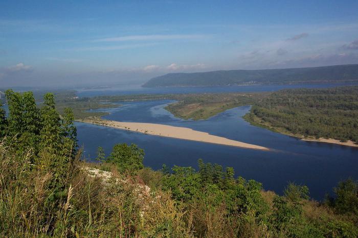
Where the Russian Plain is located, there are many rivers and lakes. The main rivers that play a major role in human economic activity are the Volga, Oka and Don.
The Volga is the largest river in Europe. The Volga-Kama hydro-industrial complex is located on it, which includes a dam, a hydroelectric power station and a reservoir. The length of the Volga is 3631 km. Many of its tributaries are used on the farm for irrigation.
Don also plays a significant role in industrial activities. Its length is 1870 km. The Volga-Don shipping canal and the Tsimlyansk reservoir are especially important.
In addition to these large rivers, the Khoper, Voronezh, Bityug, Northern Onega, Kem and others flow on the plain.
In addition to rivers, the Russian Plain includes the Barents, White, Black, Caspian.
The Nord Stream gas pipeline runs along the bottom of the Baltic Sea. This affects the ecological situation of the hydrological object. During the laying of the gas pipeline, clogging of waters occurred, many species of fish decreased their numbers.
In the Baltic, Barents, Caspian, some minerals are being mined, which, in turn, adversely affects the waters. Some of the industrial waste seeps into the seas.

In the Barents and Black Seas, some types of fish are caught on an industrial scale: cod, herring, flounder, haddock, halibut, catfish, anchovy, pike perch, mackerel, etc.
Fishing is carried out in the Caspian Sea, mainly sturgeons. Due to favorable natural conditions, there are many sanatoriums and tourist centers on the seashore. There are navigable routes along the Black Sea. Oil products are exported from Russian ports.
Groundwater of the Russian Plain
In addition to surface water, people use groundwater, which, due to irrational use, adversely affects soils - subsidence, etc. are formed. There are three large artesian basins on the plain: the Caspian, Central Russian and East Russian. They serve as a source of water supply for a vast territory.
To the question What types of natural resources are rich in the territory of the Russian Plain (except for mineral ones) and how a person uses them, given by the author trace the best answer is The natural resources of the Russian Plain are rich and varied.
1. Fuel and energy resources:
a) coal - Pechora and Moscow region basins.
b) oil and gas - the Volga-Ural field, the European North.
c) peat.
2. Mineral resources:
a) metal (iron ore) - KMA.
b) non-metallic - apatite on the Kola Peninsula, table salt-Lake Baskunchak.
Forest resources include both taiga and mixed forests, rich in valuable timber, fur-bearing game animals, mushrooms, berries, and medicinal plants.
The soil resources of the Russian Plain are of great importance, since the main areas of the most fertile soils, chernozems, are concentrated here. Especially in the Voronezh region. But these soils are subject to wind and water erosion. Therefore, for the purpose of protection, they create shelterbelts, fix ravines, follow the rules of agricultural technology and soil-protective crop rotations.
The agro-climatic resources of the plain are of great value. Most of the Russian Plain receives enough heat and moisture to grow many crops. It also needs fertile soil.
In the north of the forest zone - fiber flax, rye, oats.
The middle lane (fertile soils) - wheat, corn, sugar beet, sunflower.
To the south - horticulture, melon growing.
The water resources of the Russian Plain are also huge. The northwestern and central regions of the Russian Plain are best provided with water resources. The abundance of lakes, high-water rivers is not only fresh water reserves, but also cheap transport routes, and fisheries, and recreational areas. The dense river network of the plain, the location of watersheds on low flat hills are favorable for the construction of canals, of which there are so many on the Russian Plain. Thanks to the system of modern canals - the Volga-Baltic, White Sea-Baltic, and Moscow-Volga, Moscow, located on the relatively small river Moskva and relatively far from the seas, has become a port of five seas.
Many hydroelectric power plants with dams and reservoirs have been built on the Volga. Hydroelectric power plants provide cheap energy - that's good. But the reservoirs flooded fertile lands, which led not only to a decrease in soil resources, but also to negative environmental changes in the Volga basin.
Answer from 22 answers[guru]
Hello! Here is a selection of topics with answers to your question: What types of natural resources are rich in the territory of the Russian Plain (except for minerals) and how people use them
Answer from Lol lol[newbie]
water and hydro resources
Answer from Vlad Noble Wolf[guru]
Water and hydro resources.... Use-transport and energy.
Answer from Caucasian[guru]
On the territory of the Russian Plain, in addition to mineral resources, there are other types of resources.
1. The main areas of the most fertile soils of our country - chernozems are concentrated on the Russian Plain.
2. Agro-climatic resources are favorable for agricultural production
3. The forest resources of the part of the Russian Plain belonging to the Central Federal District of Russia are characterized by an insignificant total area of the land fund, amounting to 14,464 thousand hectares (1.3% of the Russian Federation) . The forest cover here is more than twice as low as in the whole country - 20%. The Kostroma, Kirov and Tver regions are characterized by the highest forest cover, where the forested area is more than 50% of the territory.
4. Recreational resources
The Astrakhan State Nature Reserve is located in the Volga Delta. All around water, islands overgrown with reeds, cattails, willows.
Valdai National Park is a Russian pearl of natural and cultural heritage. Its territory surprisingly combines unique landscape complexes, historical, archaeological and cultural monuments. Landscapes of Valdai are of great aesthetic value. Currently, an application is being prepared for the inclusion of the Valdaisky National Park in the UNESCO list as a world natural and cultural heritage site. The park was created to preserve the unique lake-forest complex of the Valdai Upland and create conditions for the development of organized recreation in this area.
Seliger is a lake of glacial origin in the Tver and Novgorod regions of the Russian Federation. On the lake, on the island of Stolbny, there is the monastery of Nil's Hermitage, founded in honor of Nil Stolbensky.
5. Water resources of the Russian Plain
The Russian Plain has a developed lake-river network, the density and regime of which change following climatic conditions from north to south.
- To deepen and expand knowledge about the natural resources of the Russian Plain (types and their location). Consider the problems of rational use of natural resources. Continue the formation of skills to work with sources of geographic information. To continue the development of a moral and aesthetic attitude towards nature - to show the beauty and originality of Russian nature, its significance in the spiritual life of the people.
- Educational: to expand knowledge about the natural resources of the Russian Plain. Developing: Develop the needs of self-education, use the knowledge, skills and abilities previously acquired in geography lessons. Educational: Awaken in students a sense of beauty and responsibility for the nature of their native land.
Type of lesson: learning new material.
Forms of work: individual, frontal, conversation
Equipment: presentation, physical map of Russia, books, atlases, contour maps
During the classes
Organizing time
Repetition of the studied material:
- 3-4 people work with contour maps. (Appendix) 3-4 people on cards 1 person at the blackboard (testing knowledge of the nomenclature) Frontal survey:
On what part of the earth's surface is the Russian Plain located?
-Name the shields of the Russian platform? What breeds is it made up of?
-What can you say about the climate of the Russian Plain?
Communication of the goals and objectives of the lesson:
Today, we will continue to study the nature of the East European Plain, expand our knowledge about the natural resources of the Russian Plain. Consider the problems of their rational use. Write down the topic of the lesson: Natural resources of the Russian Plain and problems of their rational use. slide 1
Learning new material:
- To complete all the above tasks, we need to answer the following questions: Slide 2
What can explain the high population density in the plains?
What natural resources does the plain have?
-What disturbances of natural landscapes are observed during mining?
-How to solve the problem of rational use of natural resources?
- So, how can one explain the high population density in the East European Plain? slide 3
The Russian Plain is rich in diverse natural resources, favorable climatic conditions, fertile soils, flat terrain: contributed to the settlement of the Russian Plain.
The value of the natural resources of the Russian Plain is determined, first of all, by their richness and diversity, as well as by their location in the most densely populated part of Russia.
What natural resources does the Russian Plain have?
Mineral water Soil and agro-climatic Forest Recreational Slide 4 (notebook entry)Phys. minute
Let's write natural resources:
Mineral resources are represented by iron ores of the Kursk magnetic anomaly. The main ore is magnetite. slide 5.6
The reserves of hard and brown coals are concentrated in the Pechora and Moscow region basins. Slide 7
Oil and gas are produced at the fields of the Volga-Ural and Timan-Pechora oil and gas regions. The gas condensate fields of the Astrakhan Region are being exploited. Slide 8
Oil shale deposits have been discovered in the Pskov and Leningrad regions, in Samara. Slide 9
Large salt deposits are discovered in the Caspian lowland. Development is carried out on the largest salt lakes - Elton and Baskunchak. Slide 10
There are industrial accumulations of phosphorites in the Moscow region (Egoryevskoye), the Volga region (Kineshmskoye, Volskoye, etc.) Slide 11
What disturbances of natural landscapes are observed during mining?
During the extraction of minerals, the lands are disturbed, their fertile layer is destroyed, new forms of relief are created, part of the lands is occupied by landslides and quarries. slide 13
Let's look at other resources.
Water resources. The Russian Plain has a significant hydropower potential - the rivers are used as transport routes for shipping and timber rafting. The northwestern and central regions of the Russian Plain are best provided for. slide 14, 15
The construction of hydroelectric power stations on large and small rivers, accompanied by the creation of reservoirs, also made a sad contribution to changing the nature of the Russian Plain. The largest reservoirs are Kuibyshev, Rybinsk, Volgograd, Tsimlyansk, Kama, Saratov. Bell tower. The city of Kalyazin after the creation of the reservoir Slide 16.
Soil and agro-climatic resources Most of the Russian Plain receives sufficient heat and moisture for the cultivation of many agricultural crops
The main areas of chernozems, the most fertile soils, are located on the Russian Plain. slide 17.18
How to solve the problem of rational use of soil? Slide 19
So that soils do not lose their fertility, their rational use is necessary: using the example of a non-chernozem zone, we will show the rational use of land. The main type of land reclamation here is the drainage of excessively moistened lands. Along with drainage, it is necessary to apply fertilizers and liming soils, remove stones and uproot tree and shrub vegetation, snow retention and regulation of snowmelt, enlargement of fields and improvement of their shape.
Forest resources The Russian Plain has large reserves of industrial wood spruce and pine taiga forests. Fur-bearing animals of the north-eastern regions of the taiga and upland game are of commercial importance. slide 20, 21, 22
Recreational resources slide 23
They are diverse, but poorly mastered.
Valdai and Lake Seliger slide 26
Lake Ladoga and Onega slide, 27.28
Astrakhan delta slide 29
"Golden Ring of Russia" slide 30, 31
As a result of human economic activity, natural landscapes give way to anthropogenic landscapes. The forests have been cut down, the steppes have been plowed up. Mining degrades landscapes, forming a "lunar" landscape with quarries and dumps.
Working with the textbook slide 32
What territories of the Russian Plain are most changed by man?
What measures are taken to preserve natural landscapes?
Let's answer the main question:
How to rationally use natural resources?
Students' opinions are heard.
Consolidation of the studied material: Performing independent work
Conclusion: The natural resources of the Russian Plain are rich and varied. The Russian Plain has been greatly altered by human activities. The burden on nature leads to crisis situations. We need to change the nature of nature management and make it rational. Rare and endangered plants and animals should be preserved and protected.
Homework paragraph 29 questions. Written Question 5
Application
On the outline map, mark:
Work on cards "Guess by description":
The nature of this region is harsh and beautiful. The first resort in Russia was built here in 1719 at the direction of Peter the Great. The mineral water source contains a large amount of iron. The name "Marcial Waters" (Karelia) The largest lake in the Russian Plain. Its area is 18100 sq. km. There are more than 660 islands on this lake. The most famous are the Vaalam Islands. (Lake Ladoga) It is called the main treasure of Valdai. There are about 160 islands on the lake. More than 100 tributaries flow into it, and only one river (Lake Seliger) flows out. It is called the worker of Russia, the mother of Russian rivers. It is the largest river in all of Europe. (Volga) In the North-East of Moscow there are several ancient Russian cities. They are interconnected by a common, not simple history and, most remarkable, by the surviving monuments of ancient Russian architecture. These lands remember Yaroslav the Wise and Vladimir Manomakh, Alexander Nevsky and Dmitry Pozharsky, famous artists, poets and writers drew their inspiration here. (Gold ring of Russia)
Independent work in the 8th grade on the topic "Natural complexes of the Russian Plain"
1. The Russian Plain is located:
A) on an ancient platform;
B) on a young platform;
B) on a shield
2. The following are timed to raise the foundation:
A) Valdai Upland;
B) Central Russian Upland;
C) Timan Ridge;
D) Northern Ridges.
3. On the shield are located:
A) the Kola Peninsula; B) Timan Ridge;
B) Karelia; D) Valdai Upland.
4. The East European Plain has a relief: A) flat; B) hilly.
5. The Russian Plain is dominated by:
A) plateaus and lowlands;
B) plateaus and hills;
C) high and low.
6. Climate of the Russian Plain:
A) marine B) temperate continental;
B) continental.
7. On the territory of most of the Russian Plain dominated by:
A) anticyclones; B) cyclones.
8. "Lakeland" is called:
A) the center of the Russian Plain;
B) northeast of the Russian Plain;
C) northwest of the Russian Plain.
9. The largest lake of the Russian Plain:
A) Ladoga; B) Onega;
B) Imandra.
10. Forests are widespread in the taiga of the Russian Plain:
A) spruce and fir; B) deciduous; C) spruce and pine.
Answers: 1-A, 2-B, 3-A, C, 4-B, 5-C, 6-C, 7-B, 8-C, 9-A, 10-C.
On the outline map, mark:
Borders of the Russian Plain Indicate the seas washing the Russian Plain: White, Barents, Kara, Baltic, Azov, Black Indicate the peninsulas: Kanin, Kola Island Novaya Zemlya Rivers: Mezen, Northern Dvina, Volga Lakes: Onega, Ladoga Uplands: Timan Ridge, Northern Uvaly Lowland: Caspian Cities: Pskov, Moscow, Arkhangelsk.
Guess from the description:
The nature of this region is harsh and beautiful. The first resort in Russia was built here in 1719 at the direction of Peter the Great. The mineral water source contains a large amount of iron. The name "Marcial Waters" (____________________) The largest lake of the Russian Plain. Its area is 18100 sq. km. There are more than 660 islands on this lake. The most famous are the Vaalam Islands. (__________________________) It is called the main treasure of Valdai. There are about 160 islands on the lake. More than 100 tributaries flow into it, and only one river flows out (______________________) It is called the worker of Russia, the mother of Russian rivers. It is the largest river in all of Europe. (______________) There are several ancient Russian cities in the North-East of Moscow. They are interconnected by a common, not simple history and, most remarkable, by the surviving monuments of ancient Russian architecture. These lands remember Yaroslav the Wise and Vladimir Manomakh, Alexander Nevsky and Dmitry Pozharsky, famous artists, poets and writers drew their inspiration here. (__________________________)
