Almost all of you have paid attention to the “mysterious lines” on maps and globes representing latitude (parallels) and longitude (meridians). They form a grid coordinate system by which any place on Earth can be precisely located - and there is nothing mysterious or complicated about it. Parallels and meridians are imaginary lines on the surface of the Earth, and latitude and longitude are their coordinates that determine the position of points on the surface of the Earth. Any point on Earth is the intersection of a parallel and a meridian with latitude and longitude coordinates. This can be most clearly studied using a globe, where these lines are indicated.
But first things first. Two places on Earth are determined by its rotation around its own axis - these are North and South Poles. On globes, the axis is the rod. The North Pole is located in the Arctic Ocean, which is covered with sea ice, and explorers in the old days reached this pole on sleds with dogs (the North Pole is officially believed to have been discovered in 1909 by the American Robert Perry). However, since the ice moves slowly, the North Pole is not an actual, but rather a mathematical object. The South Pole, on the other side of the planet, has a permanent physical location on the continent of Antarctica, which was also discovered by land explorers (a Norwegian expedition led by Roald Amundsen in 1911).
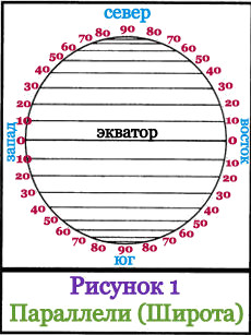 Halfway between the poles at the “waist” of the Earth there is a large line of a circle, which is represented on the globe as a seam: the junction of the northern and southern hemispheres; this circle line is called - equator. The equator is a line of latitude with a value of zero (0°). Parallel to the equator, above and below it, there are other lines of the circle - these are other latitudes of the Earth. Each latitude has a numerical value, and the scale of these values is measured not in kilometers, but in degrees north and south from the equator to the poles. The poles have the following values: North +90°, and South -90°. Latitudes located above the equator are called northern latitudes, and below the equator - southern latitudes. Lines with degrees of latitude are called parallels, since they run parallel to the Equator and are parallel to each other. If parallels are measured in kilometers, then the lengths of different parallels will be different - they increase as they approach the equator and decrease towards the poles. All points of the same parallel have the same latitude, but different longitude (longitude is described below). The distance between two parallels that differ by 1° is 111.11 km. On the globe, as well as on many maps, the distance (interval) from latitude to another latitude is usually 15° (this is approximately 1,666 km). In Figure 1, the interval is 10° (this is approximately 1,111 km). The equator is the longest parallel, its length is 40,075.7 km.
From school we remember that every point on the planet has its own coordinates. Without this data, the movement of planes and ships would be impossible, and it is difficult to imagine the modern life of mankind without knowledge of geographic coordinates. The earth's equator and prime meridian, encircling the planet, cross several continents, but only in one of them do they “meet”. We will look at which continent is crossed by the equator and the prime meridian in this short article.
To begin with, let us remember more precisely what the equator and the prime meridian are. Although this knowledge is taught in elementary school, many people do not have a clear understanding of these concepts as adults.

With the equator everything is quite simple. This is a conventional line on the surface, perpendicular to the axis of rotation of the planet. It is clear that there can only be one equator; it is the longest horizontal line of the Earth (its length is slightly greater than 40,075 km). The entire surface of the Earth located below the equator (or, to put it correctly, further south) is the Southern Hemisphere. Everything that is located above the equator belongs to the Northern Hemisphere. The Earth's equator in its movement crosses two continents: Africa and South America.
Three interesting facts about the equator:
- A person standing on the equator rotates along with the surface of the Earth at a speed significantly exceeding the speed of sound.
- It is well known that it is always hot everywhere at the equator. But in the country of Ecuador there is a high volcano standing right on the equator line. On the slopes of this volcano there is a glacier that never melts.
- In Brazil, there is a city called Macapa, which is crossed by the equator almost in the middle. This, in particular, means that when it is summer in the northern quarters of the city, at the same time it is winter in the southern quarters.
But drawing the prime meridian on the surface of the Earth was not so easy. If the equator has a completely obvious physical meaning (it is the longest of the earth’s horizontal lines), then the meridians (lines passing through the earth’s poles) are all the same, and, from the point of view of physics, any of them can be the “starting” one.
For this reason, already in ancient times, people began counting geographical longitude based on their convenience. For example, Hipparchus considered the longitude of the island of Rhodes as the starting point.
As you might expect, not everyone liked this decision. In the scientific world, there have been discussions for decades about the “legitimacy” of the Greenwich Prime Meridian. At one time, the practice even began to spread when Greenwich was used as the prime meridian for sea charts, and some other, “local” meridians for land maps.
But all disputes pass at some point, and this one passed too. Currently, no one disputes the right of the Greenwich meridian to be considered the starting meridian, zero, when determining geographic longitude.
We have already indicated which continents the equator passes through. And the Greenwich meridian crosses three continents: Eurasia and Antarctica. It is not difficult to notice that Africa is mentioned in both lists. It is the only continent on Earth through which both the equator and the Greenwich meridian pass simultaneously. True, they are not destined to meet on land. Their intersection point is in the Gulf of Guinea, just west of the African mainland.
This place is interesting! A person who finds himself here will not be able to accurately answer which hemisphere of the Earth he is in. All its geographical coordinates (both latitude and longitude) will be described by solid zeros!
Answer: ____________________
Which of the following language families belongs to the majority (89%) of the Russian population?
Altai 2) Indo-European 3) Ural 4) Caucasian
An example of rational environmental management is:
Pioneering
Fertilizer application
Creation of protective forest belts in the steppe
Change of land by mining
In which of the following regions are raw materials for ferrous and non-ferrous metallurgy mined?
Pskov region
Arhangelsk region
Vologda Region
Republic of Karelia
What type of climate is typical for the Kamchatka Peninsula?
Moderate continental
Temperate marine
Subarctic
Moderate sharply continental
Using the table data, determine the average population density in the Belgorod region in 2002. Write the answer in numbers.
| ^ Belgorod region | Republic of Kalmykia | Bryansk region | Komi Republic |
||
| Territory area, thousand km 2 | 27 | 76 | 35 | 416 |
|
| Population, thousand people | Total | 1512 | 292 | 1380 | 1018 |
| Younger than working age | 265 | 72 | 247 | 201 |
|
| Over working age | 381 | 43 | 328 | 144 |
|
Answer: ______________ people. per 1 km 2
In which of the listed regions of Russia is the administrative center a million-dollar city?
Vologda 2) Tomsk 3) Rostov 4) Magadan
The ancient city of Machu Picchu (13° S and 72° W) appears to be floating in the fog. This ancient city was accidentally discovered in 1911. An archaeological expedition climbed the mountainside through the jungle, until finally, almost at the very top, they saw buildings made of white granite blocks. The blocks were not held together with mortar. They were so tightly packed together. That it was impossible to insert even a knife blade between them. Such masonry greatly increased the strength of the walls, which is very important, since earthquakes often occur here.
The buildings at Machu Picchu were made of granite. What type of rock is granite in origin?
What is the name of the country where Machu Picchu is located?
Which continent map should you choose to study the location of Machu Picchu in more detail?
North America
Africa
South America
Eurasia
Check out the map shown in the picture. The pictures show variants of the terrain profile, constructed on the basis of a map along the A-B line by different students. Which profile is built correctly?

Arrange the regions of the country in the order in which their residents celebrate the New Year. Write down the resulting sequence of letters in the table.
B) Primorsky Krai
B) Republic of Tyva
Answer:
On December 21, day is equal to night on:
Southern Arctic Circle; 3) Northern Tropic;
equator; 4) south pole
Identify the country by its brief description:
Answer: _________________________
What process are we talking about?
Answer: _________________________
