The first mention of the Volga River dates back to ancient times when she was called as "Ra". In more later times- already in Arabic sources the river was called Atel (Ethel, Itil), which means " great river or "river of rivers". That is how the Byzantine Theophanes and subsequent chroniclers called her in the annals.
At current name"Volga" there are several versions of the origin. The version about the Baltic roots of the name seems to be the most probable. According to the Latvian valka, which means "overgrown river", the Volga got its name. This is how the river looks in its upper reaches, where the Balts lived in antiquity. According to another version, the name of the river comes from the word valkea (Finno-Ugric), which means "white" or from the ancient Slavic "volog" (moisture).
Hydrography
Since ancient times, the Volga has not lost its grandeur at all. Today it is the largest river in Russia and ranks 16th in the world among the longest rivers. Before the construction of the cascade of reservoirs, the length of the river was 3690 km, today this figure has decreased to 3530 km. At the same time, navigable navigation is carried out for 3500 km. In navigation, the channel plays an important role. Moscow, which acts as link between the capital and the great Russian river.
The Volga connects with the following seas:
- with the Azov and Black Seas through Volga-Don Canal;
- with the Baltic Sea through the Volga-Baltic waterway;
- with the White Sea along the White Sea-Baltic Canal and the Severodvinsk river system.
The waters of the Volga originate in the region of the Valdai Upland - in the spring of the village of Volga-Verkhovye, which is located in the Tver region. The height of the source above sea level is 228 meters. Further, the river carries its waters through the whole Central Russia to the Caspian Sea. The height of the fall of the river is small, because. the mouth of the river is only 28 meters below sea level. Thus, throughout its entire length, the river descends 256 meters, and its slope is 0.07%. average speed the river flow is relatively low - from 2 to 6 km/h (less than 1 m/s).
Feed the Volga mainly melt water, which account for 60% annual runoff. 30% of the runoff comes from groundwater (they support the river in winter) and only 10% brings rain (mainly in summer period). Throughout its length, 200 tributaries flow into the Volga. But already at the latitude of Saratov, the water basin of the river narrows, after which the Volga flows from the city of Kamyshin to the Caspian Sea without support from other tributaries.
From April to June, the Volga is characterized by a high spring flood, which lasts an average of 72 days. The maximum level of water rise in the river is observed in the first half of May, when it spills over the floodplain territory for 10 or more kilometers. And in the lower reaches - in the Volga-Akhtuba floodplain, the width of the flood in places reaches 30 km.
Summer is characterized by a stable low-water period, which lasts from mid-June to early October. Rains in October bring with them an autumn flood, after which a period of low-water winter low water begins, when the Volga is fed only by groundwater.
It should also be noted that after the construction of a whole cascade of reservoirs and regulation of the flow, fluctuations in the water level became much less significant.
The Volga freezes in its upper and middle reaches, usually at the end of November. In the lower reaches, ice rises in early December.
Ice drift on the Volga in the upper reaches, as well as in the section from Astrakhan to Kamyshin, occurs in the first half of April. In the area near Astrakhan, the river usually breaks up in mid-March.
At Astrakhan, the river remains ice-free for almost 260 days a year, while in other sections this time is about 200 days. During the period open water the river is actively used for ship navigation.
The main part of the river catchment falls on the forest zone, located from the very source to Nizhny Novgorod. The middle part of the river passes through the forest-steppe zone, and Bottom part flows through semi-deserts.
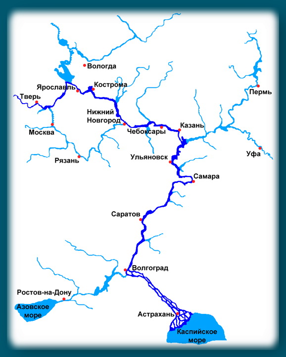
Volga Map
Different Volga: Upper, Middle and Lower
According to the classification adopted today, the Volga in its course is divided into three parts:
- The Upper Volga captures the section from the source to the confluence of the Oka (in the city of Volga). Nizhny Novgorod);
- The Middle Volga extends from the mouth of the Oka River to the confluence of the Kama;
- The Lower Volga starts from the mouth of the Kama River and reaches the Caspian Sea itself.
As for the Lower Volga, some adjustments should be made. After the construction of the Zhigulevskaya hydroelectric power station just above Samara and the facilities Kuibyshev reservoir, today's border between the middle and lower sections of the river passes just at the level of the dam.
Upper Volga
In its upper course, the river made its way through the system of the Upper Volga lakes. Between Rybinsk and Tver, 3 reservoirs are of interest to anglers: Rybinskoye (the famous "fish"), Ivankovskoye (the so-called "Moscow Sea") and the Uglich reservoir. Even further downstream, bypassing Yaroslavl and as far as Kostroma, the riverbed passes through a narrow valley with high banks. Then, a little higher than Nizhny Novgorod, there is the dam of the Gorky hydroelectric power station, which forms the Gorky reservoir of the same name. The most significant contribution to the Upper Volga is made by such tributaries as: Unzha, Selizharovka, Mologa and Tvertsa.
Middle Volga
Beyond Nizhny Novgorod, the Middle Volga begins. Here the width of the river increases by more than 2 times - the Volga becomes full-flowing, reaching a width of 600 m to 2+ km. Near the city of Cheboksary, after the construction of the Cheboksary hydroelectric power station of the same name, an extended reservoir was formed. The area of the reservoir is 2190 square km. The largest tributaries of the Middle Volga are the rivers: Oka, Sviyaga, Vetluga and Sura.
Lower Volga
The Lower Volga begins immediately after the confluence of the Kama River. Here the river, indeed, can be called mighty in all respects. The Lower Volga carries its full-flowing streams along the Volga Upland. Near the city of Togliatti on the Volga, the most large reservoir- Kuibyshevskoye, where in 2011 there was a disaster with the notorious motor ship Bulgaria. The reservoir of the Volga hydroelectric power station named after Lenin is propped up. Even further downstream, near the city of Balakovo, the Saratov hydroelectric power station was built. The tributaries of the Lower Volga are no longer so full of water, these are the rivers: Samara, Eruslan, Sok, Big Irgiz.
Volga-Akhtuba floodplain
Below the city of Volzhsky, a left branch called Akhtuba separates from the great Russian river. After the construction of the Volga hydroelectric power station, the beginning of the Akhtuba was a 6 km canal extending from the root Volga. Today, the length of Akhtuba is 537 km, the river carries its waters to the northeast parallel to the mother channel, then approaching it, then moving away again. Together with the Volga, Akhtuba forms the famous Volga-Akhtuba floodplain - a real fishing eldorado. The floodplain territory is pierced by numerous channels, saturated with flood lakes and unusually rich in all kinds of fish. The width of the Volga-Akhtuba floodplain averages from 10 to 30 km.
By territory Astrakhan region The Volga makes a journey of 550 km, carrying its waters along the Caspian lowland. At the 3038th kilometer of its journey, the Volga River splits into 3 branches: Bold Curve, City and Trusovsky. And in the section from 3039 to 3053 km, the city of Astrakhan is located along the branches of the City and Trusovsky.
Below Astrakhan, the river makes a turn to the southwest and splits into numerous branches that form a delta.
Volga Delta
The Volga delta first begins to form in a place where one of the branches called Buzan separates from the main channel. This place is located above Astrakhan. In general, the Volga delta has over 510 branches, small channels and eriks. The delta is located on total area in 19 thousand square kilometers. In width, the distance between the western and eastern branches of the delta reaches 170 km. AT generally accepted classification the Volga delta consists of three parts: upper, middle and lower. The zones of the upper and middle deltas consist of small islands separated by channels (eriks) 7 to 18 meters wide. The lower part of the Volga delta consists of very branched channel channels, which pass into the so-called. Caspian peals, famous for their lotus fields.
Due to the lowering of the level of the Caspian Sea over the past 130 years, the area of the Volga delta is also growing. During this time, it has increased more than 9 times.
Today, the Volga delta is the largest in Europe, but is famous primarily for its rich fish stocks.
Note that vegetable animal world The delta is under protection - the Astrakhan Reserve is located here. Therefore, amateur fishing in these places is regulated and not allowed everywhere.

The economic role of the river in the life of the country
Since the 30s of the last century, electricity has been produced on the river with the help of hydroelectric power stations. Since then, 9 hydroelectric power plants with their reservoirs have been built on the Volga. On the this moment the river basin sheltered approximately 45% of industry and half of all Agriculture Russia. More than 20% of all fish are caught in the Volga basin for Food Industry RF.
The logging industry is developed in the Upper Volga basin, and in the Middle and Lower Volga grow crops. Horticulture and horticulture are also developed along the middle and lower reaches of the river.
The Volga-Ural region is rich in deposits natural gas and oil. Near the city of Solikamsk there are deposits of potassium salts. The famous lake Baskunchak on the Lower Volga is famous not only for its healing mud, but also for its salt deposits.
Upstream ships carry oil products, coal, gravel materials, cement, metal, salt and food products. Downstream supplies timber, industrial raw materials, lumber and finished products.
Animal world

Tourism and fishing on the Volga
In the mid-90s of the last century, due to the economic decline in the country water tourism on the Volga lost its popularity. The situation was normalized only at the beginning of this century. But the outdated material and technical base hinders the development of the tourism business. Motor ships that were built back in Soviet times(60-90 years of the last century). There are quite a lot of water tourist routes along the Volga. From Moscow alone, motor ships run on more than 20 different routes.
Russia is the largest country in the world by area. On the vast territory the largest rivers of the Earth flow: Ob, Yenisei, Lena, Amur. Among them is the longest river in Europe - the Volga. Its length is 3530 km, and the basin area is 1360 thousand m2.
The Volga River flows in the European part of Russia: from the Valdai Upland in the west, along east side- to the Urals, in the south of the country flows into the Caspian Sea. Not most of delta enters the territory of Kazakhstan.
The source of the river is located on the Valdai Upland, in the village of Volgoverkhovye, Tver Region. A small stream, receiving about 150,000 tributaries, including 200 small and large rivers, is gaining power and strength and turns into a mighty river. A special monument to the river was erected at the place of its source.
The fall of the river along its length does not exceed 250 m. The mouth of the river lies 28 m below sea level. The territory of Russia adjacent to the Volga is called the Volga region. There are four million-plus cities along the banks of the river: Nizhny Novgorod, Kazan, Samara and Volgograd. First major locality on the Volga from the source - the city of Rzhev, and the last in the delta - Astrakhan. The Volga is the world's largest river of internal flow, i.e. not flowing into the oceans.

The main part of the Volga area, from the source to Nizhny Novgorod and Kazan, is located in the forest zone, middle part basin to Samara and Saratov - in the forest-steppe zone, the lower part - to Volgograd in the steppe zone, and to the south in the semi-desert zone.
It is customary to divide the Volga into three parts: the upper Volga - from the source to the mouth of the Oka, the middle Volga - from the confluence of the Oka to the mouth of the Kama, and the lower Volga - from the confluence of the Kama to the confluence of the Caspian Sea.
River history
For the first time, a Greek scientist spoke about the river. Then information about the Volga is found in the notes of the Persian king Darius, who described his campaigns against the Scythian tribes. Roman sources speak of the Volga as a "generous river", hence the name - "Ra". In Russia, the river is spoken of in the famous Tale of Bygone Years.
Since the time of Russia, the Volga has been an important trading link - the artery where the Volga trade route. Through this route, Russian merchants traded in oriental fabrics, metal, honey, and wax.

After the conquest of the Volga basin, the heyday of trade began, which peaked in the 17th century. Over time, a river fleet arose on the Volga.
In the 19th century, an army of barge haulers worked on the Volga, which is the subject of a painting by a Russian artist. At that time, huge supplies of salt, fish, and bread were transported along the Volga. Then cotton was added to these goods, and later oil.
During the period civil war The Volga was the main strategic point, which provided the army with bread and food, and also made it possible to quickly transfer forces with the help of the fleet.
 Painting by Ilya Repin "Barge haulers on the Volga", 1872-1873
 When was established in Russia Soviet authority, the river began to be used as a source of electricity. In the 20th century, 8 hydroelectric power plants were built on the Volga.
During the Second World War, the Volga was the most important river for the USSR, as armies and food supplies were transferred through it. In addition, on the Volga, in Stalingrad (now Volgograd), the largest battle took place.
Now the Volga basin is producing oil and natural gas reserves that support the Russian economy. In some areas potash and table salt are mined.
Flora and fauna of the river
The Volga is predominantly fed by snow (60%), some is rain fed (10%), and ground water feed the Volga by 30%. The water in the river is warm, summer time the temperature does not fall below + 20-25 degrees. The river freezes at the end of November in the upper reaches, and in the lower reaches - in December. The river is frozen 100-160 days a year.

Large populations of fish live in the river: crucian carp, zander, perch, ide, pike. Catfish, burbot, ruff, sturgeon, bream and sterlet also live in the waters of the Volga. In total there are about 70 species of fish.
Birds settle in the Volga delta: ducks, swans, herons. Flamingos and pelicans live on the Volga. And the famous flowers grow - lotuses. Although the Volga is heavily polluted industrial enterprises, it still retains aquatic vegetation (lotus, water lily, reed, water chestnut).
Tributaries of the Volga
Approximately 200 tributaries flow into the Volga, and most of them are on the left side. The left tributaries are much more abundant than the right ones. The largest tributary of the Volga is the Kama River. Its length reaches 2000 km. The beginning of the tributary takes on the Verkhnekamsk Upland. Kama has more than 74 thousand tributaries, 95% are rivers up to 10 km long.

Hydrotechnical studies also indicate that the Kama is older than the Volga. And here's the last one ice Age and the construction of reservoirs on the Kama seriously reduced its length.
In addition to the Kama, tributaries of the Volga stand out:
- Sura;
- Tvertsa;
- Sviyaga;
- Vetluga;
- Unzha;
- Mologa and others.
Tourism on the Volga
The Volga is a picturesque river, so tourism is flourishing on it. The Volga makes it possible to short term visit a large number of Volga cities. Cruises along the Volga are a common type of recreation on the river.

The journey lasts from 3-5 days to a month. It includes visiting the most beautiful cities of the country, located along the Volga. The favorable period for traveling along the Volga is from the beginning of May to the end of September.
- The Kama, a tributary of the Volga, hosts an annual sailing competition, the largest in Europe.
- The Volga appears in literary and works of art Russian classics:, Repin.
- About the Volga art films, including "Volga, Volga" in 1938, "A bridge is under construction" in 1965.
- The Volga is considered to be the "homeland of barge haulers." Sometimes 600 thousand barge haulers could work hard at the same time.
- A controversial point: it is generally accepted that the Kama is a tributary of the Volga River. But geographers and hydrologists are still arguing which of the rivers is the main one. The fact is that at the confluence of the Volga rivers carries 3100 cubic meters water per second, but the "productivity" of Kama is 4300 cubic meters per second. It turns out that the Volga ends just below Kazan, and then the Kama River already flows, and it is the Kama that flows into the Caspian Sea.

- The Arabs, impressed by the scale of the Volga, called it "Itil", which means "river" in Arabic.
- The Volga pours 250 cubic kilometers of water into the Caspian Sea every day. However, the level of this sea continues to decline steadily.
- On May 20, Volga Day is celebrated in Russia.
I am grateful for audiobooks in many ways. And they deserve my respect only because they gave some good reasons for posts on their favorite subsite - Marty.
Here I am listening to lectures by A. A. Auzan, kindly provided by skodnik on the MP3Biblion subsite, and I catch myself thinking:
"Yeah well, it can't be."
In the fifth part of his lectures on institutional economics Alexander Alexandrovich, respected by me, himself with surprise says literally the following:
Today I will refute things that are settled and seem obvious. I'll start with an example that shocked me a couple of years ago.
This is a classic Russian platitude: the Volga is believed to flow into the Caspian Sea.
No, it is not the Volga that flows into the Caspian Sea, but the Chusovaya.
From now on, I will take a break and begin my investigation or, if you like, research. It will consist in searching for sources of information from which the above statement follows.
I think this post will cause serious controversy, because the thesis expressed overturns our understanding of the correctness of the existing state of affairs.
First assertion.
The Volga River is a tributary of the Kama! Why?
First Scientific research were carried out in 1876, and it turned out that, according to hydrological signs:
1. The Kama is more full-flowing than the Volga.
The main part of its basin is located in the taiga zone, where more precipitation falls, which, together with countless Ural tributaries, makes the Kama a mighty river.
2. Kama is older than the Volga.
As a result of studies of the silty deposits of these rivers, it was proved that the Kama existed several million years before the appearance of the Volga.
In the first half of the Quaternary, before the era of maximum glaciation, the Volga in modern form did not have.
There was the Kama, which, uniting with the Vishera, flowed directly into the Caspian Sea. Glaciation led to the reorganization of the hydrographic network, and the upper Volga, which had previously given its waters to the Don, began to flow into the Kama, moreover, almost at a right angle.
3. The bed of the Kama is below.
Since water does not flow upward, it is logical that it is the Volga that flows into the Kama. Let's pay attention to this part of the phrase and remember it - "since water does not flow upwards, it is logical that ..."
The Volga does not flow into the Caspian Sea. And it's not a sensation, says Dr. geographical sciences, Professor of the Faculty of Geography and Geophysics of KSU, Corresponding Member of the Academy of Water Management Problems of the Russian Federation Vladimir Ilyich Mozzherin, who has already for a long time deals with the problems of large rivers. – The fact that the Volga does not flow into the Caspian Sea has long been known.
Another thing is that this fact has never been widely publicized, and only geographers know about it. True, there is one caveat. In official geography in all scientific papers concerning the Volga and Kama, it is written in black and white that the Volga flows into the Caspian Sea.
From the point of view of science, this statement is false.
According to the reports of Roshydromet to the Ministry natural resources and ecology: the length of the Kama is 1805 km (before the construction of the dams, it was more than 2000 km), and the length of the Volga is 1390 km.
At their confluence, Kama carries 4300 cubic meters. m / s, and the Volga - 3100 cubic meters. m/s.
The difference is big, you see. There is an explanation for this. The main part of the Kama basin is located in the taiga zone, where more than in middle lane, rainfall, and snow melts slowly and unevenly. In addition, the Kama receives more than 70 thousand tributaries.
The Volga is different. It has fewer tributaries, and they are located not in the taiga, but in more southern zone. There, the snow melts very quickly, and water flows into the river in large portions. In addition, almost the entire length of the Volga is regulated, as experts say, by reservoirs.
In nature, for several decades there has been no river called the Volga. How so?
“Indeed, the Volga has long ceased to be a river in the full sense of the word,” explains Professor Mozzerin. - In 1983, the last of the nine reservoirs, Cheboksary, was launched. From that moment on, the Volga turned into a network of reservoirs, or, it would be more correct to say, a cascade of large flowing lakes. Let's call a spade a spade - creating reservoirs, a man personally destroyed Mother Volga.
The Kama is also regulated, but its reservoirs are much smaller in volume.
Considering all these factors, we can conclude that the Kama is more full-flowing, and, therefore, it is the Volga that is the tributary of the Kama, and not vice versa.
Therefore, the river flowing into the Caspian Sea should be called Kama.
The second statement.
Any Permian who listened attentively to the teacher in geography lessons, with young years It is known that the Chusovaya River flows into the Caspian Sea!
Hydrographically, the Kama flows into the Vishera, the Vishera flows into the Chusovaya, into which the Volga also flows, and then the Chusovaya flows into the Caspian Sea!
The Kama flows into the Chusovaya. Why?
Let's see what the inflow of a river is from the point of view of science.
A tributary is a watercourse that flows into a larger watercourse. Usually differs from the latter in shorter length and water content. However, there are also reverse examples: much more full-flowing Oka and Kama are considered tributaries of the Volga; just as the Angara is listed as a tributary of the Yenisei, which has twice the water content at the confluence.
So, after all, Chusovaya flows into the Kama?
There are contradictions in this position. Remember, I asked you to keep in mind the part of the phrase "since water does not flow upwards, it makes sense that..."? So, the channel of the Chusovaya river is below the channel of the Kama.
Given in abbreviation.
With her "Rostov mountains" and " sea coast Belarus", on I have an even happier generation coming.
According to the results of a 2014 survey, less than 60% of the students of the Faculty of Journalism of Moscow State University were able to confidently say where the Volga flows. Students went through options from the Azov and Black to the North and Baltic Seas, at the Higher School of Economics they suggested that the Volga flows into Baikal, Oka, Pacific Ocean, and Moscow State University - to the Moscow River, Yenisei, Ob. Some students decided that "the Volga does not flow anywhere."
In total, 151 students of the Faculty of Journalism of Moscow State University were surveyed, 84 students high school economics and 35 MGIMO students in about equal number from all courses. Answer options were not offered to students. The candidates were chosen randomly. Not a single student could answer all the questions, 15 people could not answer any question at all. You can test yourself by passing a simple test, created on the basis of assigned to students questions.
Modern the common truth "Volga flows into the Caspian Sea" is quite enough to know d for general development. But those who want to understand history should keep in mind that this statement is essentially false and first understand hydrological concepts.
Firstly, it would be more correct to talk about the confluence of the river into Caspian lake, because parts of the World Ocean are called seas, and the Caspian Sea is an endorheic lake that has no connection with the World Ocean and is traditionally called the sea, apparently because of its salty water and large size.
In other words, river basin The Volga with the Caspian Sea-lake isinland system waterways completely isolated from the World Ocean. And this circumstance must be taken into account when studying the history of civilization, which spread mainly along the seas and waterways.
For example, there are only three "entry points" to the Volga basin from different seas to understand their historical significance.
1. From Baltic Sea the first route along the rivers Neva - Volkhov - Msta - Tvertsa, that is, the cities of St. Petersburg-Veliky Novgorod - Tver. That is why here, and not somewhere else, the capital was founded Russian Empire- Petersburg.
2. From the Black Sea along the Dnieper through the island of Khortitsa (base Zaporozhye Cossacks) and Kyiv in the upper reaches of the Dnieper there is the iconic "key-city" Smolensk, then on the tributary of the Dnieper the key city of Vyazma, from where it was possible to get to the upper reaches of the Oka and Volga basins.
3. From Sea of Azov along the Don, then along the Tsimlya tributary (the Tsimlyansk reservoir is now on the site of this river) and dragged to the Volga near modern Volgograd. To anal Volga-Don approximately corresponds toto the former land portage and it is not at all accidental that it was there in the settlement of Dubok that administrative center Volga Cossacks, and not in the area of the mouth of the river like all other river Cossacks. Yes, yes, that's right, every Cossack army initially controlled its river, the Cossacks in general were originally waterfowl and only at the turn of the 18-19 centuries they moved to horses.
Secondly, not the Volga, but the Kama flows into the Caspian Sea-lake. According to one of the main hydrological criteria - full-flowing, at the confluence of the Volga and Kama, the latter is more full-flowing + an additional criterion of a direct channel at the confluence, the Volga should be considered a tributary of the Kama, and not vice versa, and then it is the Kama that flows into the Caspian Sea. Therefore, the ancient authors are not at all mistaken when they write that the Ra (Volga) river flows from the Riphean / Riphean(Ural) mountains.
River basins can be compared to standing next to trees with closed crowns. Like trees along trunks, all rivers are uniquely identified from the mouth, and further up the river, for transport purposes, the main watercourse must be determined, which is not always obvious.
For example, at the confluence of the Volga with the Oka, the latter was full-flowing and, according to this criterion, could be considered the main watercourse, in which case it would be considered that the Volga flows into the Oka. But in this place the Volga has a straight channel and at approximately equal visual assessments full flow, it wins the Oka the right to be called the main watercourse.
In other words, the name of the river used to extend to the watercourse starting from the mouth and upstream, based on the practical purposes of navigation. In the 19th century, this principle was reversed, appointing "one of the branches of the tree crown" as the source of the river - this is simpler, but does not make any practical sense, shipping distances in many places are still counted from the mouths of the rivers.
So the answer topoll "Where does the Volga flow?"most consider it well-known, primitive only because ofmodern view of rivers from top to bottom, from source to mouth andfamiliarity clearcertainty of the main stream.
In Europe, the Volga is the largest river, but in Russia it is only in fifth place in terms of size. In the Tver region, there is a village Volgoverkhovye. Near it stands a chapel - this is the place where the Volga River originates.
Even before our era, the Egyptians, Greeks and Slavs who lived at that time called it Ra, the incarnation of the sun god, and those places where it flows, the sacred country of Iriy (Paradise).
In the Middle Ages, since the place where the Volga River originates is in Russia, it received Russian name, which means "wetland" or "flowing stream". But the Turks who lived downstream gave it the name "Itil", that is, "endless", "river of rivers".

In total, it overcomes the path of 3530 km. And if the beginning of the Volga River is a tiny swampy stream, and the first bridge across it is only 3 meters long, then after 10 km it flows into Lake Sterzh, once the first of the Upper Volga lakes, which have now turned into one reservoir. Having passed the chain of former lakes, the river becomes full-flowing and flows to Tver in its original course. A little lower, another reservoir begins, it is often called However, before it represents several man-made lakes, and only on the Caspian lowland does the Volga acquire its natural channel 500 km long. And before flowing into the Caspian Sea, it forms many branches that make up a vast delta (about 19,000 sq. Km).
Today, the Volga is distinguished by its majestic, measured flow, in other places it is even difficult to notice. Although earlier, when there were no dams and reservoirs on it, its temper was steeper, with rifts. The memory of this remained only in the names of coastal cities and towns and in old legends. But in the lower reaches and in places of reservoirs, it can be dangerous, in contrast to the places where it originates.

The Volga River has more than two hundred tributaries, which themselves are full-flowing and large rivers. For example, the Kama tributary is the largest, it is even fuller and longer in length than its "mother". And in total, the Volga basin has more than 150 thousand more or less major rivers(whose length is over 10 km)
If you believe the guidebooks, then along the Volga you can get to almost any corner of the world. And being near the chapel, where the Volga River originates, you can’t say this at all.
With absolute accuracy, we can only say that it is realistic to go on a cruise from Moscow to Nizhny Novgorod, St. Petersburg or Astrakhan. The capital can be reached through the Moscow Canal. You will get to the Azov and Black Seas with the help of A Volga-Baltic route will take you to while the White Sea-Baltic and North Dvina routes will take you to
In addition to the fact that you can cruise along the river, the Volga is a source of large fish resources. About 70 species of fish live there, most of which are commercial. This is herring, and stellate sturgeon, and vobla, and sterlet with sturgeon, and bream with pike. It is not for nothing that fishermen from all over our vast country, and from abroad, aspire to go there.

And if you decide to go on a trip, then start from the places where the Volga River originates, where it is still just a small stream, which after a few hundred kilometers becomes the great Russian river, striking in its beauty and majesty.
